METAR & TAF KLDM
Current METAR
Observed 16:35Z
KLDM 271635Z AUTO 09005KT 10SM BKN080 BKN110 24/18 A2973 RMK AO2
- Wind
- 090° @ 5 kt
- Visibility
- 10 SM
- Temp / Dew
- 24°C / 18°C
- Altimeter
- 29.73 inHg
- Clouds
- BKN
- Density alt
- 2,117 ft
- Ceiling
- 8,000 ft AGL
- Rules
- VFR
Airport info & contacts
Manager on record, flight service, ARTCC, attendance schedule and pattern altitude — published by the FAA and refreshed every 28 days.
Location
- From city
- 2 NM NE
- VFR sectional
- CHICAGO
- ARTCC
- ZMP · MINNEAPOLIS
- NOTAM facility
- LDM (NOTAM-D)
Airport manager
- Name
- JOHN L O'CONNOR
- Phone
- 231-843-2049
- Address
- 5300 W US HIGHWAY 10, LUDINGTON MI 49431-8704
Flight service · Hours
- FSS LAN
- LANSING1-800-WX-BRIEF
- Attendance
- APR 16-OCT 15 · 0900-1700
- OCT 16-APR 15 · MON-FRI · 0900-1700
- OCT 16-APR 15 · SAT-SUN · Unattended
Frequencies
Tap any row to copy the frequency to your clipboard.
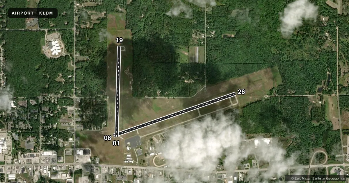
Runways & pattern
Full pagePattern entry · RWY 08
LEFT TRAFFIC| Runway | Heading (°M) | Length | Surface | Traffic |
|---|---|---|---|---|
| 08/26Favored | 68° / 248° | 5,003 ft | ASPH | Standard L |
| 01/19 | 359° / 179° | 3,503 ft | ASPH | Standard L |
Runway end performance
| End | TORA | TODA | ASDA | LDA | VGSI | Approach lights | Obstruction |
|---|---|---|---|---|---|---|---|
| 08 | — | — | — | — | PAPI 2-box left(3°) | — | — |
| 26 | — | — | — | — | PAPI 4-box left(3°) | — | 59', tree, 1375' from thr, 421' R of cntrln, slope 19 |
| 01 | — | — | — | — | PAPI 2-box left(3°) | — | — |
| 19 | — | — | — | — | PAPI 2-box left(3°) | — | 68', tree, 1363' from thr, 265' R of cntrln, slope 17 |
Declared distances in feet. TORA = takeoff run available, TODA = takeoff distance, ASDA = accelerate-stop, LDA = landing distance.
Airport sketch
Runways drawn to scale from FAA survey coordinates, rendered over satellite imagery. Not for navigation.
Approaches & charts
Services on the field
Fuel grades, oxygen, maintenance, ramp storage and lighting — as declared to the FAA by the airport operator.
Fuel & services
- Fuel
- 100LLA+
- Airframe repair
- Not available
- Power plant repair
- Not available
Ramp & ground
- Transient storage
- Tie-down
- Hangar
- Landing fee
- No fee published
- Customs
- Not available
- Lighting schedule
- SEE RMK
- Beacon schedule
- SS-SR
- Beacon
- White / Green (civil land)(WG)
- Wind indicator
- Yes
- Segmented circle
- Yes
Fuel & FBOs
Cheapest 100LL and Jet A on the field and nearby. Always confirm with the FBO before taxi.
Airport notes
Surface conditions, obstructions, local procedures, lighting outages and other notes published with each FAA cycle.
General notes
- DEER, LRG BIRDS, & WILDLIFE ON & INVOF ARPT.
- FOR CD IF UNA TO CTC ON FSS FREQ, CTC MINNEAPOLIS ARTCC AT 651-463-5588.
Lighting notes
- ACTVT REIL RWY 26; PAPI RWY 08, 26, 01, & 19; MIRL RWY 08/26 & 01/19 - CTAF.
VFR map & nearby airports
VFR sectional. Tap any ICAO chip to open that airport.
Key facts · KLDM
Answer card- ICAO
- KLDM
- Name
- MASON COUNTY
- Location
- LUDINGTON, MICHIGAN
- Elevation
- 646.6 ft MSL
- Traffic pattern altitude
- 1,646.6 ft MSL (1,000 AGL)
- Control tower
- Non-towered (use CTAF)
- Total runways
- 2
- Longest runway
- 08/26 · 5,003 ft
- Published ILS approaches
- 0
- Published frequencies
- 2
- Magnetic variation
- 3°
- Current flight rules
- VFR
- Current wind
- 090° at 5 kt
- Favored runway now
- RWY 08
Mason County Airport is in Ludington, Michigan. The field elevation is 646.6 ft MSL. It has two asphalt runways. The longest is 5,003 ft on runway 08/26. There is no control tower, so plan on CTAF and UNICOM self-announce work on 123.0.
No ILS approaches are published here. Pattern altitude is not published, so use the standard 1,000 ft AGL for light piston traffic unless the current FAA Chart Supplement says otherwise. The on-field FBO is Mason County Airport. It carries 100LL and Jet A Prist. Call (231) 843-2049 for current service details before you go.
The published remarks matter here. Runway end identifier lights are on runway 26. PAPI is installed on runways 08, 26, 01 and 19. Medium intensity runway lights are on both runways. Deer. Large birds. Other wildlife are reported on and near the airport, so keep a sharp scan on taxi, takeoff and landing. If you need clearance delivery and cannot reach flight service, Minneapolis ARTCC is listed as the backup contact. For a first-time arrival, verify the current Chart Supplement for any local procedures before you depart.