METAR & TAF 4Y9
4Y9 does not publish a METAR.
Showing the nearest reporting station: KCAD (WEXFORD COUNTY) · 15.3 NM away. Conditions at 4Y9 may differ.
METAR · KCAD
Observed 07:15Z
KCAD 240715Z AUTO 35001KT 10SM CLR 10/09 A3012 RMK AO2
- Wind
- 350° @ 1 kt
- Visibility
- 10 SM
- Temp / Dew
- 10°C / 9°C
- Altimeter
- 30.12 inHg
- Clouds
- CLR
- Density alt
- 383 ft
- Ceiling
- Unlimited
- Rules
- VFR
Airport info & contacts
Manager on record, flight service, ARTCC, attendance schedule and pattern altitude — published by the FAA and refreshed every 28 days.
Location
- From city
- 3 NM W
- VFR sectional
- GREEN BAY
- ARTCC
- ZMP · MINNEAPOLIS
- NOTAM facility
- LAN (NOTAM-D)
Airport manager
- Name
- MIKE WOODLEY
- Phone
- 586-944-7101
- Address
- 9491 W 30 RD, HARRIETTA MI 49638-9408
Flight service · Hours
- FSS LAN
- LANSING1-800-WX-BRIEF
- Attendance
- Unattended
Frequencies
Tap any row to copy the frequency to your clipboard.
Runways & pattern
Full pagePattern entry · RWY 08
LEFT TRAFFICRunway end performance
| End | TORA | TODA | ASDA | LDA | VGSI | Approach lights | Obstruction |
|---|---|---|---|---|---|---|---|
| 08 | — | — | — | — | — | — | 77', trees, 0' from thr, 115' R of cntrln, slope 0 |
| 26 | — | — | — | — | — | — | 47', trees, 0' from thr, 114' R of cntrln, slope 0 |
Declared distances in feet. TORA = takeoff run available, TODA = takeoff distance, ASDA = accelerate-stop, LDA = landing distance.
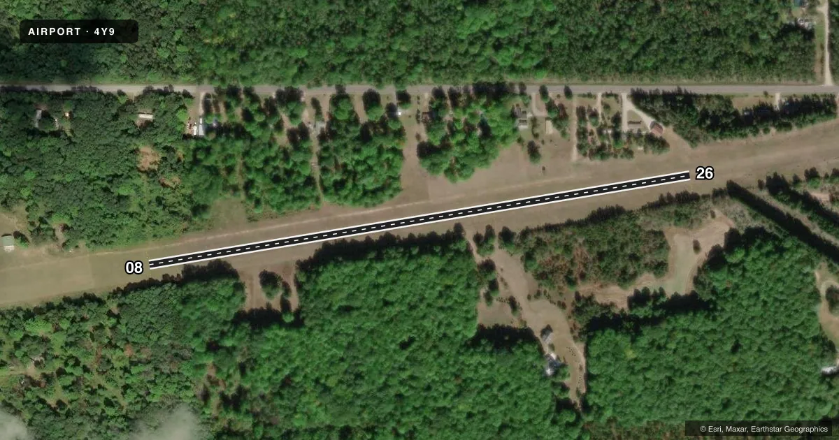
Airport sketch
Runways drawn to scale from FAA survey coordinates, rendered over satellite imagery. Not for navigation.
Approaches & charts
Services on the field
Fuel grades, oxygen, maintenance, ramp storage and lighting — as declared to the FAA by the airport operator.
Fuel & services
- Fuel
- Not available
- Oxygen (bottled)
- Not available
- Oxygen (bulk)
- Not available
- Airframe repair
- Not available
- Power plant repair
- Not available
Ramp & ground
- Transient storage
- Not published
- Landing fee
- No fee published
- Wind indicator
- Yes
- Segmented circle
- No
Fuel & FBOs
Cheapest 100LL and Jet A on the field and nearby. Always confirm with the FBO before taxi.
Airport notes
Surface conditions, obstructions, local procedures, lighting outages and other notes published with each FAA cycle.
General notes
- 60 FT TREES BOTH SIDES OF RWY, 100 FT FM RWY CNTRLN.
- LRG DEPRESSION EAST OF RWY 26.
- NO SNOW REMOVAL.
- FOR CD CTC MINNEAPOLIS ARTCC AT 651-463-5588.
Approach & departure obstructions
- 083 FT YELLOW CONES.
- 263 FT YELLOW CONES.
- 08CTLG OBSTN EXCEEDS A 45 DEG SLP.
- 26CTLG OBSTN EXCEEDS A 45 DEG SLP.
VFR map & nearby airports
VFR sectional. Tap any ICAO chip to open that airport.
Key facts · 4Y9
Answer card- ICAO
- 4Y9
- Name
- EAGLES LANDING
- Location
- HARRIETTA, MICHIGAN
- Elevation
- 993 ft MSL
- Traffic pattern altitude
- 1,993 ft MSL (1,000 AGL)
- Control tower
- Non-towered (use CTAF)
- Total runways
- 1
- Longest runway
- 08/26 · 2,200 ft
- Published ILS approaches
- 0
- Published frequencies
- 1
- Magnetic variation
- –
- Current flight rules
- VFR
- Current wind
- 350° at 1 kt
- Favored runway now
- RWY 08
Eagles Landing (4Y9) is in Harrietta, Michigan. The field elevation is 993 ft MSL. It has one runway. Runway 08/26 is 2,200 ft of turf, which makes this a short-field, soft-surface stop for light aircraft. The airport is non-towered. CTAF is 122.9.
No ILS approaches are published here. Pattern altitude is not published, so use the standard 1,000 ft AGL for light piston operations unless the current FAA Chart Supplement says otherwise. The runway is marked with three-foot yellow cones at both ends. Published remarks also note a large depression east of runway 26. Sixty-foot trees sit on both sides of the runway about 100 ft from the centerline. Obstacles are listed on both runway ends, so a stabilized approach matters here.
No on-field FBOs are listed. That means fuel and other services need to be confirmed with the airport operator or by calling ahead before you go. No snow removal is provided, so winter use needs extra caution. For clearance delivery, contact Minneapolis ARTCC at 651-463-5588. If you are planning a first visit, check the current FAA Chart Supplement for any additional local notes before departure.