METAR & TAF 7Y2
7Y2 does not publish a METAR.
Showing the nearest reporting station: KFKS (FRANKFORT DOW MEML FLD) · 11.8 NM away. Conditions at 7Y2 may differ.
METAR · KFKS
Observed 17:15Z
KFKS 271715Z AUTO 18007KT 6SM -RA BR OVC110 20/19 A2972 RMK AO2 PRESFR
- Wind
- 180° @ 7 kt
- Visibility
- 6 SM
- Temp / Dew
- 20°C / 19°C
- Altimeter
- 29.72 inHg
- Clouds
- OVC
- Density alt
- 1,831 ft
- Ceiling
- 11,000 ft AGL
- Rules
- VFR
Airport info & contacts
Manager on record, flight service, ARTCC, attendance schedule and pattern altitude — published by the FAA and refreshed every 28 days.
Location
- From city
- 2 NM W
- VFR sectional
- GREEN BAY
- ARTCC
- ZMP · MINNEAPOLIS
- NOTAM facility
- LAN (NOTAM-D)
Airport manager
- Name
- DAVE TERHAAR
- Phone
- 616-403-3469
- Address
- 13998 HONOR HWY, BEULAH MI 49617-9762
Flight service · Hours
- FSS LAN
- LANSING1-800-WX-BRIEF
- Attendance
- Unattended
Frequencies
Tap any row to copy the frequency to your clipboard.
Runways & pattern
Full pagePattern entry · RWY 17
LEFT TRAFFIC| Runway | Heading (°M) | Length | Surface | Traffic |
|---|---|---|---|---|
| 09/27 | 82° / 262° | 2,900 ft | ASPH | 09 R |
| 17/35Favored | 166° / 346° | 2,475 ft | TURF | 35 R |
Runway end performance
| End | TORA | TODA | ASDA | LDA | VGSI | Approach lights | Obstruction |
|---|---|---|---|---|---|---|---|
| 09 | — | — | — | — | — | — | 14', road, 240' from thr, 0' R of cntrln, slope 2 |
| 27 | — | — | — | — | PAPI 2-box left(4°) | — | — |
| 17 | — | — | — | — | — | — | 69', trees, 43' from thr, 110' R of cntrln, slope 0 |
| 35 | — | — | — | — | — | — | 63', trees, 18' from thr, 0' R of cntrln, slope 0 |
Declared distances in feet. TORA = takeoff run available, TODA = takeoff distance, ASDA = accelerate-stop, LDA = landing distance.
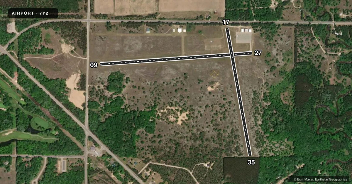
Airport sketch
Runways drawn to scale from FAA survey coordinates, rendered over satellite imagery. Not for navigation.
Approaches & charts
Services on the field
Fuel grades, oxygen, maintenance, ramp storage and lighting — as declared to the FAA by the airport operator.
Fuel & services
- Fuel
- Not available
Ramp & ground
- Transient storage
- Tie-down
- Landing fee
- No fee published
- Lighting schedule
- SEE RMK
- Beacon schedule
- SS-SR
- Beacon
- White / Green (civil land)(WG)
- Wind indicator
- Lighted
- Segmented circle
- Yes
Fuel & FBOs
Cheapest 100LL and Jet A on the field and nearby. Always confirm with the FBO before taxi.
Airport notes
Surface conditions, obstructions, local procedures, lighting outages and other notes published with each FAA cycle.
General notes
- +450 FT UNLGTD SKI HILL, 0.5 NM WEST OF ARPT.
- ADMIN BLDG & RESTROOM ACES: 5-3-2-1.
- FOR CD CTC MINNEAPOLIS ARTCC AT 651-463-5588.
Lighting notes
- ARPT ROTG BCN ON SKI HILL, 450 FT ABV ARPT ELEV, 1.0 MI NW.
- ACTVT PAPI RWY 27; LIRL RWY 09/27 - 5 CLICKS CTAF (3 CLICKS OFF).
Runway surface & condition
- 17/35CLSD TO TSNT ACFT CTC AMGR FOR DTLS; CLSD NOV-MAR & WHEN SNOW COVD. NO SNOW REMOVAL.
Approach & departure obstructions
- 09+4 FT FENCE, 185 FT DIST, L/R.
- 17RWY & DTHR MKD WITH 3 FT YELLOW CONES.
- 35RWY & DTHR MKD WITH 3 FT YELLOW CONES.
- 09APCH SLP 17:1 TO DTHR OVR 96 FT TREE, 1678 FT DIST.
- 17CTLG OBSTN EXCEEDS A 45 DEG SLP. APCH SLP 18:1 TO DTHR OVR 76 FT TREES, 1440 FT DIST.
- 35CTLG OBSTN EXCEEDS A 45 DEG SLP. APCH SLP 17:1 TO DTHR OVR 63 FT TREES, 1103 FT DIST.
Other notes
- ESTABD BFR 1959.
- MANAGERCELL. RES 231-378-2435.
VFR map & nearby airports
VFR sectional. Tap any ICAO chip to open that airport.
Key facts · 7Y2
Answer card- ICAO
- 7Y2
- Name
- THOMPSONVILLE
- Location
- THOMPSONVILLE, MICHIGAN
- Elevation
- 793 ft MSL
- Traffic pattern altitude
- 1,793 ft MSL (1,000 AGL)
- Control tower
- Non-towered (use CTAF)
- Total runways
- 2
- Longest runway
- 09/27 · 2,900 ft
- Published ILS approaches
- 0
- Published frequencies
- 1
- Magnetic variation
- 4°
- Current flight rules
- VFR
- Current wind
- 180° at 7 kt
- Favored runway now
- RWY 17
Thompsonville Airport (7Y2) sits in Thompsonville, Michigan. Field elevation is 793 ft MSL. The airport has two runways. The longest is 09/27 at 2,900 ft asphalt. Runway 17/35 is 2,475 ft turf. There is no control tower. CTAF is 122.9.
No ILS approaches are published here. Pattern altitude is not published, so use standard traffic pattern planning at 1,000 ft AGL for light piston operations unless the current Chart Supplement says otherwise. Runway 27 has a PAPI. Runways 09 and 27 have low intensity edge lights. They are controlled by five clicks on CTAF. Three clicks turns them off. Runway 17 and runway 35 are marked with 3-foot yellow cones at the runway and displaced thresholds.
There are no on-field FBOs listed. Check with the airport operator or the FBO directly by phone before you go if you need services. Published remarks also note a fence near runway 09, trees on the approach to 09 and 35 and a 450-foot unlighted ski hill about 0.5 NM west of the field. Runway 17/35 is closed to transient aircraft. It is closed from November through March and when snow covered. No snow removal is provided. For clearance delivery, contact Minneapolis ARTCC at 651-463-5588.