METAR & TAF KFKS
Current METAR
Observed 15:15Z
KFKS 271515Z AUTO 28005KT 10SM CLR 28/19 A2977 RMK AO2 PRESRR
- Wind
- 280° @ 5 kt
- Visibility
- 10 SM
- Temp / Dew
- 28°C / 19°C
- Altimeter
- 29.77 inHg
- Clouds
- CLR
- Density alt
- 2,531 ft
- Ceiling
- Unlimited
- Rules
- VFR
Airport info & contacts
Manager on record, flight service, ARTCC, attendance schedule and pattern altitude — published by the FAA and refreshed every 28 days.
Location
- From city
- 2 NM SE
- VFR sectional
- GREEN BAY
- ARTCC
- ZMP · MINNEAPOLIS
- NOTAM facility
- FKS (NOTAM-D)
Airport manager
- Name
- BROOKE TRENTHAM POPP
- Phone
- 231-352-9118
- Address
- 650 AIRPORT RD, FRANKFORT MI 49635-9785
Flight service · Hours
- FSS LAN
- LANSING1-800-WX-BRIEF
- Attendance
- IREG
Frequencies
Tap any row to copy the frequency to your clipboard.
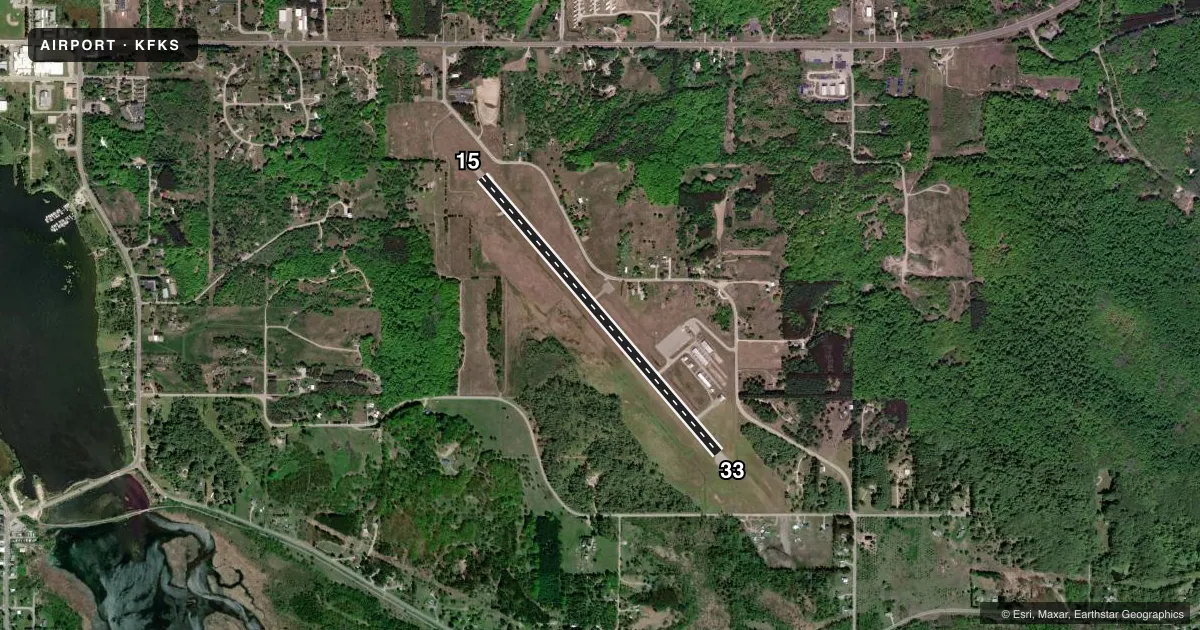
Runways & pattern
Full pagePattern entry · RWY 33
LEFT TRAFFICRunway end performance
| End | TORA | TODA | ASDA | LDA | VGSI | Approach lights | Obstruction |
|---|---|---|---|---|---|---|---|
| 15 | — | — | — | — | — | — | 20', road, 201' from thr, 230' R of cntrln, slope 0 |
| 33 | — | — | — | — | PAPI 2-box right(3°) | — | 54', tree, 896' from thr, 285' R of cntrln, slope 12 |
Declared distances in feet. TORA = takeoff run available, TODA = takeoff distance, ASDA = accelerate-stop, LDA = landing distance.
Airport sketch
Runways drawn to scale from FAA survey coordinates, rendered over satellite imagery. Not for navigation.
Approaches & charts
Services on the field
Fuel grades, oxygen, maintenance, ramp storage and lighting — as declared to the FAA by the airport operator.
Fuel & services
- Fuel
- 100LL
- Oxygen (bottled)
- Not available
- Oxygen (bulk)
- Not available
Ramp & ground
- Transient storage
- Tie-down
- Landing fee
- Yes
- Customs
- Not available
- Lighting schedule
- SEE RMK
- Beacon schedule
- SS-SR
- Beacon
- White / Green (civil land)(WG)
- Wind indicator
- Lighted
- Segmented circle
- Yes
Fuel & FBOs
Cheapest 100LL and Jet A on the field and nearby. Always confirm with the FBO before taxi.
Airport notes
Surface conditions, obstructions, local procedures, lighting outages and other notes published with each FAA cycle.
General notes
- DEER & BIRDS ON & INVOF ARPT.
- ADMIN BLDG ACES: PRESS 5-3-2-1.
- HANG GLIDER ACTIVITY ALONG LAKE MICHIGAN LAKESHORE.
- FOR CD CTC MINNEAPOLIS ARTCC AT 651-463-5588.
Lighting notes
- ARPT BCN LOCATED ON HILL 1.25 MILES NW OF ARPT.
- ACTVT REIL RWY 33; PAPI RWY 33; MIRL RWY 15/33 - CTAF (3 MIKE CLICKS TURNS OFF).
Fuel notes
- 100LLAVBL SELF SVC VIA CREDIT CARD.
Approach & departure obstructions
- 15+20 FT ROAD.
- 15APCH RATIO 17:1 TO DTHR.
- 33APCH RATIO 18:1 TO DTHR.
Other notes
- RAMP FEE DTRMD BY WT.
- 4FOR ON CALL ATTENDANT CALL AMGR.
- MANAGERCELL 231-383-2126.
VFR map & nearby airports
VFR sectional. Tap any ICAO chip to open that airport.
Key facts · KFKS
Answer card- ICAO
- KFKS
- Name
- FRANKFORT DOW MEML FLD
- Location
- FRANKFORT, MICHIGAN
- Elevation
- 633.2 ft MSL
- Traffic pattern altitude
- 1,633.2 ft MSL (1,000 AGL)
- Control tower
- Non-towered (use CTAF)
- Total runways
- 1
- Longest runway
- 15/33 · 4,050 ft
- Published ILS approaches
- 0
- Published frequencies
- 2
- Magnetic variation
- 4°
- Current flight rules
- VFR
- Current wind
- 280° at 5 kt
- Favored runway now
- RWY 33
Frankfort Dow Meml Fld sits in Frankfort, Michigan. The field elevation is 633.2 ft MSL. It has one runway. Runway 15/33 is 4,050 ft long with an asphalt surface. There is no control tower. CTAF and UNICOM are both 123.05. No ILS approaches are published here.
Pattern altitude is not published. Use the current FAA Chart Supplement before flight. If you are operating a light piston airplane, the standard 1,000 ft AGL pattern is the normal starting point unless published otherwise. The field is on the Lake Michigan side of the state, so watch the shoreline weather and be ready for changing winds. Deer and birds are reported on and near the airport. Hang glider activity also occurs along the lakeshore, so keep a sharp lookout in the traffic area.
Frankfort Dow Memorial Field is the on-field FBO. It carries 100LL. Self-serve fuel is available by credit card. The runway lighting setup includes runway end identifier lights and a precision approach path indicator on runway 33. Runways 15 and 33 have medium intensity runway lights. The CTAF uses three microphone clicks to turn the lights off. The airport beacon is on a hill 1.25 miles northwest of the airport. For clearance delivery, contact Minneapolis ARTCC. If you need the ramp or admin building, check the airport manager or the published access code.