METAR & TAF Y87
Y87 does not publish a METAR.
Showing the nearest reporting station: KFKS (FRANKFORT DOW MEML FLD) · 13.0 NM away. Conditions at Y87 may differ.
METAR · KFKS
Observed 16:15Z
KFKS 271615Z AUTO 29006KT 10SM -RA FEW055 FEW080 BKN110 21/19 A2980 RMK AO2 PRESFR
- Wind
- 290° @ 6 kt
- Visibility
- 10 SM
- Temp / Dew
- 21°C / 19°C
- Altimeter
- 29.80 inHg
- Clouds
- BKN
- Density alt
- 2,039 ft
- Ceiling
- 11,000 ft AGL
- Rules
- VFR
Airport info & contacts
Manager on record, flight service, ARTCC, attendance schedule and pattern altitude — published by the FAA and refreshed every 28 days.
Location
- From city
- 3 NM SE
- VFR sectional
- GREEN BAY
- ARTCC
- ZMP · MINNEAPOLIS
- NOTAM facility
- LAN (NOTAM-D)
Airport manager
- Name
- LANCE ROMAN
- Phone
- 231-326-5194
- Address
- PO BOX 204, EMPIRE MI 49630-0204
Flight service · Hours
- FSS LAN
- LANSING1-800-WX-BRIEF
- Attendance
- Unattended
Frequencies
Tap any row to copy the frequency to your clipboard.
Runways & pattern
Full pagePattern entry · RWY 27
LEFT TRAFFIC| Runway | Heading (°M) | Length | Surface | Traffic |
|---|---|---|---|---|
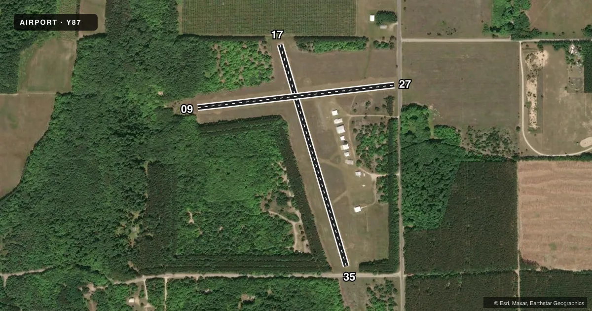
| 17/35 | 159° / 339° | 2,600 ft | ASPH | Standard L |
| 09/27Favored | 79° / 259° | 2,235 ft | TURF | Standard L |
Runway end performance
| End | TORA | TODA | ASDA | LDA | VGSI | Approach lights | Obstruction |
|---|---|---|---|---|---|---|---|
| 17 | — | — | — | 2,400' | — | — | 10', trees, 200' from thr, 125' R of cntrln, slope 0 |
| 35 | — | — | — | 2,400' | — | — | 16', brush, 380' from thr, 21' R of cntrln, slope 11 |
| 09 | — | — | — | — | — | — | 17', brush, 50' from thr, 33' R of cntrln, slope 2 |
| 27 | — | — | — | — | — | — | 15', road, 33' from thr, 125' R of cntrln, slope 2 |
Declared distances in feet. TORA = takeoff run available, TODA = takeoff distance, ASDA = accelerate-stop, LDA = landing distance.
Airport sketch
Runways drawn to scale from FAA survey coordinates, rendered over satellite imagery. Not for navigation.
Approaches & charts
Services on the field
Fuel grades, oxygen, maintenance, ramp storage and lighting — as declared to the FAA by the airport operator.
Fuel & services
- Fuel
- Not available
- Oxygen (bottled)
- Not available
- Oxygen (bulk)
- Not available
- Airframe repair
- Not available
- Power plant repair
- Not available
Ramp & ground
- Transient storage
- Tie-down
- Hangar
- Landing fee
- No fee published
- Customs
- Not available
- Lighting schedule
- SEE RMK
- Wind indicator
- Yes
- Segmented circle
- Yes
Fuel & FBOs
Cheapest 100LL and Jet A on the field and nearby. Always confirm with the FBO before taxi.
Airport notes
Surface conditions, obstructions, local procedures, lighting outages and other notes published with each FAA cycle.
General notes
- CAMPGROUND ADJACENT TO ARPT; CALL 231-326-5285.
- RWY 35 WIND SOCK 110 FT EAST OF RWY CNTRLN.
- FOR CD CTC MINNEAPOLIS ARTCC AT 651-463-5588.
- DEER, BIRDS & WILDLIFE ON & INVOF ARPT.
Lighting notes
- ACTVT LIRL RWY 17/35 - CTAF. LIRL RWY 17/35 OTS NOV-APR.
Runway surface & condition
- 09/27CLSD DEC-MAR & WHEN SN COVD EXC FOR SKI EQUIPPED ACFT, NO SN REMOVAL.
Approach & departure obstructions
- 17+9 FT FENCE, 90 FT DIST, 125 FT L/R.
- 35+15 FT ROAD, 105 FT DIST, 125 FT L/R.
- 09RWY & DTHR MKD WITH 3 FT YELLOW CONES.
- 27RWY & DTHR MKD WITH 3 FT YELLOW CONES.
- 17CTLG OBSTN EXCEEDS A 45 DEG SLP.
- 27APCH RATIO 20:1 TO DTHR.
- 35APCH RATIO 20:1 TO DTHR OVR 88 FT TREES, 1760 FT DIST, 100 FT R.
Other notes
- ESTABD BFR 1959.
- OWNEREMPIRE VILLAGE OFC 231-326-5466, EMPIRE TWP OFC 231-326-5182.
- 09/27UNEVEN ROLLING TRRN.
VFR map & nearby airports
VFR sectional. Tap any ICAO chip to open that airport.
Key facts · Y87
Answer card- ICAO
- Y87
- Name
- WILLIAM B BOLTON
- Location
- EMPIRE, MICHIGAN
- Elevation
- 944 ft MSL
- Traffic pattern altitude
- 1,944 ft MSL (1,000 AGL)
- Control tower
- Non-towered (use CTAF)
- Total runways
- 2
- Longest runway
- 17/35 · 2,600 ft
- Published ILS approaches
- 0
- Published frequencies
- 1
- Magnetic variation
- 4°
- Current flight rules
- VFR
- Current wind
- 290° at 6 kt
- Favored runway now
- RWY 27
William B Bolton is in Empire, Michigan. The field elevation is 944 ft MSL. It has two runways. The longest is runway 17/35 at 2,600 ft on asphalt. Runway 09/27 is 2,235 ft on turf. There is no control tower. CTAF is 122.9.
No ILS approaches are published here. The pattern altitude is not published. Use the standard 1,000 ft AGL for light piston traffic unless local guidance says otherwise. The airport sits in a coastal northern Michigan setting with no tower, so plan your arrival with a good lookout and expect self-announce traffic.
Published remarks matter here. Runway 09/27 is closed from December through March and when snow covered except for ski-equipped aircraft. No snow removal is performed. The turf runway has uneven rolling terrain. The 09 and 27 displaced thresholds are marked with 3-foot yellow cones. On runway 17, there is a cataloged obstruction that exceeds a 45 degree slope. Runway 35 has a road close to the end, plus trees on the approach path. There is no on-field FBO listed, so verify services with the airport operator or call the field directly before arrival.