METAR & TAF 5D5
5D5 does not publish a METAR.
Showing the nearest reporting station: KCVX (CHARLEVOIX MUNI) · 15.2 NM away. Conditions at 5D5 may differ.
METAR · KCVX
Observed 19:35Z
KCVX 271935Z AUTO 35007KT 10SM CLR 26/21 A2968 RMK AO2
- Wind
- 350° @ 7 kt
- Visibility
- 10 SM
- Temp / Dew
- 26°C / 21°C
- Altimeter
- 29.68 inHg
- Clouds
- CLR
- Density alt
- 2,396 ft
- Ceiling
- Unlimited
- Rules
- VFR
Airport info & contacts
Manager on record, flight service, ARTCC, attendance schedule and pattern altitude — published by the FAA and refreshed every 28 days.
Location
- From city
- 3 NM NE
- VFR sectional
- GREEN BAY
- ARTCC
- ZMP · MINNEAPOLIS
- NOTAM facility
- LAN (NOTAM-D)
Airport manager
- Name
- THOMAS M WETHERBEE
- Phone
- 231-386-9841
- Address
- PO BOX 338, NORTHPORT MI 49670-0338
Flight service · Hours
- FSS LAN
- LANSING1-800-WX-BRIEF
- Attendance
- Unattended
Frequencies
Tap any row to copy the frequency to your clipboard.
Runways & pattern
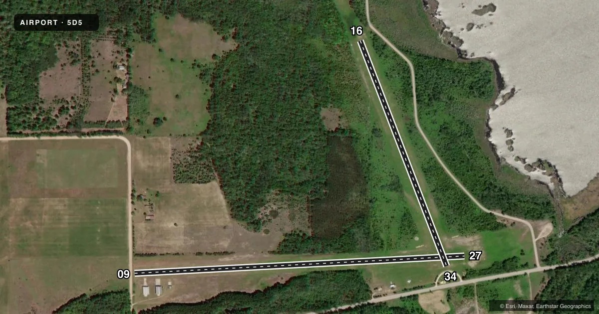
Full pagePattern entry · RWY 34
LEFT TRAFFIC| Runway | Heading (°M) | Length | Surface | Traffic |
|---|---|---|---|---|
| 09/27 | 82° / 262° | 3,663 ft | TURF | Standard L |
| 16/34Favored | 154° / 334° | 2,670 ft | TURF | Standard L |
Runway end performance
| End | TORA | TODA | ASDA | LDA | VGSI | Approach lights | Obstruction |
|---|---|---|---|---|---|---|---|
| 09 | — | — | — | — | — | — | 14', road, 35' from thr, 0' R of cntrln, slope 2 |
| 27 | — | — | — | — | — | — | 60', trees, 1330' from thr, 100' R of cntrln, slope 22 |
| 16 | — | — | — | — | — | — | 27', trees, 0' from thr, 122' R of cntrln, slope 0 |
| 34 | — | — | — | — | — | — | 10', road, 50' from thr, 0' R of cntrln, slope 5 |
Declared distances in feet. TORA = takeoff run available, TODA = takeoff distance, ASDA = accelerate-stop, LDA = landing distance.
Airport sketch
Runways drawn to scale from FAA survey coordinates, rendered over satellite imagery. Not for navigation.
Approaches & charts
Services on the field
Fuel grades, oxygen, maintenance, ramp storage and lighting — as declared to the FAA by the airport operator.
Fuel & services
- Fuel
- Not available
Ramp & ground
- Transient storage
- Tie-down
- Landing fee
- No fee published
- Lighting schedule
- SEE RMK
- Wind indicator
- Lighted
- Segmented circle
- Yes
Fuel & FBOs
Cheapest 100LL and Jet A on the field and nearby. Always confirm with the FBO before taxi.
Airport notes
Surface conditions, obstructions, local procedures, lighting outages and other notes published with each FAA cycle.
General notes
- ARPT CLSD NOV-MAR & WHEN SNOW COVD EXC FOR SKI EQUIPPED ACFT.
- DEER, BIRDS, & WILDLIFE ON & INVOF ARPT.
- FOR CD CTC MINNEAPOLIS ARTCC AT 651-463-5588.
Lighting notes
- ACTVT LIRL RWY 09/27 - CTAF.
Approach & departure obstructions
- 09RWY & DTHR MKD WITH 3 FT YELLOW CONES.
- 16RWY & DTHR MKD WITH 3 FT YELLOW CONES.
- 273 FT YELLOW CONES.
- 34RWY & DTHR MKD WITH 3 FT YELLOW CONES.
- 09APCH RATIO 20:1 TO DTHR.
- 16APCH RATIO 20:1 TO DTHR OVR +48 FT TREE, 960 FT DIST, 125 FT R.
- 34CTLG OBSTN EXCEEDS A 45 DEG SLP. APCH RATIO 18:1 TO DTHR OVR 34 FT TREE, 620 FT DIST; 25:1 OVR 17 FT BLDG, 425 FT DIST, L OF CNTRLN.
Other notes
- ESTABD BFR 1959.
- 09/27UPSLP FM WEST TO EAST.
- 16/34UPSLP FM NORTH TO SOUTH.
VFR map & nearby airports
VFR sectional. Tap any ICAO chip to open that airport.
Key facts · 5D5
Answer card- ICAO
- 5D5
- Name
- WOOLSEY MEML
- Location
- NORTHPORT, MICHIGAN
- Elevation
- 628 ft MSL
- Traffic pattern altitude
- 1,628 ft MSL (1,000 AGL)
- Control tower
- Non-towered (use CTAF)
- Total runways
- 2
- Longest runway
- 09/27 · 3,663 ft
- Published ILS approaches
- 0
- Published frequencies
- 1
- Magnetic variation
- 5°
- Current flight rules
- VFR
- Current wind
- 350° at 7 kt
- Favored runway now
- RWY 34
Woolsey Meml (5D5) sits in Northport, Michigan. Field elevation is 628 ft MSL. The airport has two turf runways. The longest is 09/27 at 3,663 ft. There is no control tower. CTAF is 122.9.
No ILS approaches are published here. Pattern altitude is not published, so use the standard 1,000 ft AGL for light piston traffic unless the current FAA Chart Supplement says otherwise. The field has low intensity runway lights on 09/27. Those lights are activated by CTAF. Published remarks also note that the airport is closed November through March. It is also closed when snow covered except for ski equipped aircraft.
Runway 09/27 slopes upward from west to east. Runway 16/34 slopes upward from north to south. Published remarks also call out deer, birds and other wildlife in the area. That matters here. Plan a careful arrival and departure, especially at low light. Runway 09, 16, 27 and 34 all have yellow cone markings at the runway ends or displaced thresholds. There are no on-field FBOs listed, so verify services with the airport operator before you go.