METAR & TAF 6Y3
6Y3 does not publish a METAR.
Showing the nearest reporting station: KSJX (BEAVER ISLAND) · 15.5 NM away. Conditions at 6Y3 may differ.
METAR · KSJX
Observed 06:15Z
KSJX 270615Z AUTO VRB06KT 10SM FEW008 21/21 A2977 RMK AO2
- Wind
- VAR @ 6 kt
- Visibility
- 10 SM
- Temp / Dew
- 21°C / 21°C
- Altimeter
- 29.77 inHg
- Clouds
- FEW
- Density alt
- 1,698 ft
- Ceiling
- Unlimited
- Rules
- VFR
Airport info & contacts
Manager on record, flight service, ARTCC, attendance schedule and pattern altitude — published by the FAA and refreshed every 28 days.
Location
- From city
- 1 NM NE
- VFR sectional
- GREEN BAY
- ARTCC
- ZMP · MINNEAPOLIS
- NOTAM facility
- LAN (NOTAM-D)
Airport manager
- Name
- GENERAL GRANT
- Phone
- 313-912-6161
- Address
- 1711 W COLLEGE ST, BOZEMAN MT 59715-4913
Flight service · Hours
- FSS LAN
- LANSING1-800-WX-BRIEF
- Attendance
- Unattended
Frequencies
Tap any row to copy the frequency to your clipboard.
Runways & pattern
Full pagePattern entry · RWY 07
LEFT TRAFFICRunway end performance
| End | TORA | TODA | ASDA | LDA | VGSI | Approach lights | Obstruction |
|---|---|---|---|---|---|---|---|
| 07 | — | — | — | — | — | — | 36', trees, 10' from thr, 65' R of cntrln, slope 0 |
| 25 | — | — | — | — | — | — | 63', trees, 0' from thr, 80' R of cntrln, slope 0 |
Declared distances in feet. TORA = takeoff run available, TODA = takeoff distance, ASDA = accelerate-stop, LDA = landing distance.
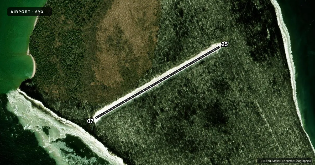
Airport sketch
Runways drawn to scale from FAA survey coordinates, rendered over satellite imagery. Not for navigation.
Approaches & charts
Services on the field
Fuel grades, oxygen, maintenance, ramp storage and lighting — as declared to the FAA by the airport operator.
Fuel & services
- Fuel
- Not available
Ramp & ground
- Transient storage
- Tie-down
- Wind indicator
- Yes
Fuel & FBOs
Cheapest 100LL and Jet A on the field and nearby. Always confirm with the FBO before taxi.
Airport notes
Surface conditions, obstructions, local procedures, lighting outages and other notes published with each FAA cycle.
General notes
- REMOTE ISLAND, NO SVCS & NO SHELTER & NO CELL PHONE COVERAGE.
- BIRDS, WILDLIFE, & SNAKES ON & INVOF ARPT.
- ARPT CLSD NOV-APR & WHEN SNOW COVD; RWYS NOT PLOWED & SOFT IN SPRING & AFT RAIN.
- TALL TREES ALQUADS.
- SEE DNR RULES POSTED NEAR PRKG.
- FOR CD CTC MINNEAPOLIS ARTCC AT 651-463-5588.
- OVERFLY THE FLD BFR ENTERING TFC PAT.
- WATCH FOR ACFT TAXIING & TAKING OFF BFR LDG.
- SAFETY BRIEFING & PILOT INFO AVBL AT HTTPS://THERAF.ORG/
Approach & departure obstructions
- 07RWY & DTHR MKD WITH 3 FT YELLOW CONES.
- 25RWY & DTHR MKD WITH 3 FT YELLOW CONES.
Other notes
- PER ASN 2015-AGL-7385-NRA.
- TIEDOWNS NOT PRVDD.
- UNREL DUE TO TREES.
- OWNEREXTN 6030 OR 231-732-3541 EXTN 5430.
VFR map & nearby airports
VFR sectional. Tap any ICAO chip to open that airport.
Key facts · 6Y3
Answer card- ICAO
- 6Y3
- Name
- NORTH FOX ISLAND
- Location
- NORTH FOX ISLAND, MICHIGAN
- Elevation
- 639 ft MSL
- Traffic pattern altitude
- 1,639 ft MSL (1,000 AGL)
- Control tower
- Non-towered (use CTAF)
- Total runways
- 1
- Longest runway
- 07/25 · 3,001 ft
- Published ILS approaches
- 0
- Published frequencies
- 1
- Magnetic variation
- –
- Current flight rules
- VFR
- Current wind
- 000° at 6 kt
- Favored runway now
- RWY 07
North Fox Island Airport (6Y3) sits on North Fox Island in Michigan. Field elevation is 639 ft MSL. The airport has one runway. Runway 07/25 is 3,001 ft of turf, so plan for soft-field performance and a careful look at runway condition before you go. No tower is listed. CTAF is the main self-announce frequency at 122.9.
No ILS approaches are published here. Pattern altitude is not published in the facts, so use the standard 1,000 ft AGL pattern unless the current FAA Chart Supplement says otherwise. This is a remote island field with no services, no shelter and no cell coverage. The airport is closed November through April and when snow covered. The runway is not plowed. It can be soft in spring and after rain. Tall trees are in all quadrants. Birds, wildlife and snakes are reported near the airport. The wind indicator is unreliable because of the trees.
There are no on-field FBOs listed. Tiedowns are not provided. For clearance delivery, contact Minneapolis ARTCC at 651-463-5588. A first-time pilot should treat this as a remote, limited-support strip and verify current conditions with the airport operator before departure.