METAR & TAF 6Y8
6Y8 does not publish a METAR.
Showing the nearest reporting station: KSJX (BEAVER ISLAND) · 2.6 NM away. Conditions at 6Y8 may differ.
METAR · KSJX
Observed 16:15Z
KSJX 271615Z AUTO 24004KT 10SM -RA FEW036 FEW049 SCT100 22/21 A2970 RMK AO2
- Wind
- 240° @ 4 kt
- Visibility
- 10 SM
- Temp / Dew
- 22°C / 21°C
- Altimeter
- 29.70 inHg
- Clouds
- SCT
- Density alt
- 1,936 ft
- Ceiling
- Unlimited
- Rules
- VFR
Airport info & contacts
Manager on record, flight service, ARTCC, attendance schedule and pattern altitude — published by the FAA and refreshed every 28 days.
Location
- From city
- 2 NM S
- VFR sectional
- GREEN BAY
- ARTCC
- ZMP · MINNEAPOLIS
- NOTAM facility
- LAN (NOTAM-D)
Airport manager
- Name
- PAUL WELKE
- Phone
- 231-675-5297
- Address
- 36155 EAST SIDE DR, BEAVER ISLAND MI 49782
Flight service · Hours
- FSS LAN
- LANSING1-800-WX-BRIEF
- Attendance
- ALL
Frequencies
Tap any row to copy the frequency to your clipboard.
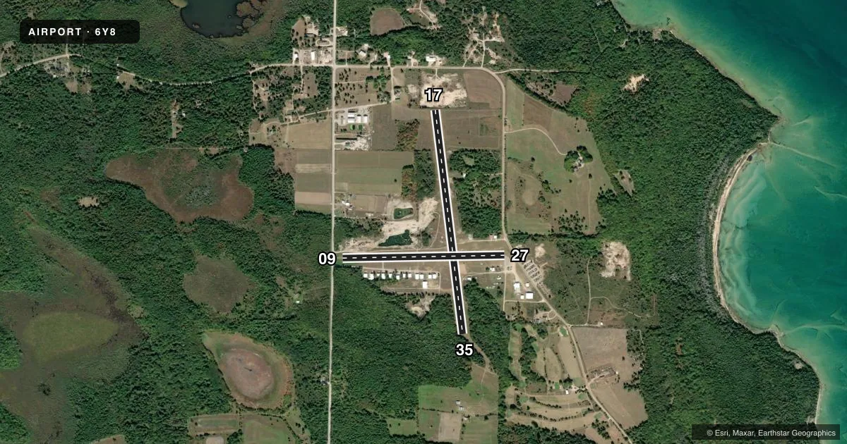
Runways & pattern
Full pagePattern entry · RWY 27
LEFT TRAFFIC| Runway | Heading (°M) | Length | Surface | Traffic |
|---|---|---|---|---|
| 17/35 | 168° / 348° | 3,500 ft | TURF | Standard L |
| 09/27Favored | 84° / 264° | 2,512 ft | ASPH | Standard L |
Runway end performance
| End | TORA | TODA | ASDA | LDA | VGSI | Approach lights | Obstruction |
|---|---|---|---|---|---|---|---|
| 17 | — | — | — | — | — | — | 15', brush, 30' from thr, 70' R of cntrln, slope 2 |
| 35 | — | — | — | — | — | — | 70', trees, 0' from thr, 70' R of cntrln, slope 0 |
| 09 | — | — | — | — | — | — | 40', trees, 200' from thr, 125' R of cntrln, slope 0 |
| 27 | — | — | — | — | — | — | 15', road, 200' from thr, 20' R of cntrln, slope 0 |
Declared distances in feet. TORA = takeoff run available, TODA = takeoff distance, ASDA = accelerate-stop, LDA = landing distance.
Airport sketch
Runways drawn to scale from FAA survey coordinates, rendered over satellite imagery. Not for navigation.
Approaches & charts
Services on the field
Fuel grades, oxygen, maintenance, ramp storage and lighting — as declared to the FAA by the airport operator.
Fuel & services
- Fuel
- Not available
- Oxygen (bottled)
- Not available
- Oxygen (bulk)
- Not available
- Airframe repair
- Major
- Power plant repair
- Major
- Other services
- CHTR
Ramp & ground
- Transient storage
- Tie-down
- Hangar
- Landing fee
- No fee published
- Lighting schedule
- SEE RMK
- Beacon schedule
- SS-SR
- Beacon
- White / Green (civil land)(WG)
- Wind indicator
- Yes
- Segmented circle
- Yes
Fuel & FBOs
Cheapest 100LL and Jet A on the field and nearby. Always confirm with the FBO before taxi.
Airport notes
Surface conditions, obstructions, local procedures, lighting outages and other notes published with each FAA cycle.
General notes
- DEER & BIRDS ON & INVOF ARPT.
- QUARRY, DIRT PILES, & EQPT 165 FT NORTH OF AER 09 & 0-500 FT NORTH OF AER 17.
- 10-15 FT DROP OFF NORTH OF AER 17.
- FOR CD CTC MINNEAPOLIS ARTCC AT 651-463-5588.
Lighting notes
- NSTD LIRL RWY 09/27 NOT FOR PUB USE EXC WITH PRIOR APVL - CALL AMGR.
Runway surface & condition
- 09/27NSTD LIRL DUE TO LCTN 87 FT L & R OF CNTRLN.
Approach & departure obstructions
- 0915 FT ROAD, 160 FT DIST, 125 FT L/R.
- 2715 FT ROAD, 90 FT DIST, 125 FT R.
- 17RWY & DTHR MKD WITH 3 FT YELLOW CONES.
- 35RWY & DTHR MKD WITH 3 FT YELLOW CONES.
- 09APCH RATIO 7:1 TO DTHR.
- 17APCH RATIO 15:1 TO DTHR.
- 27APCH RATIO 20:1 TO DTHR.
- 35APCH RATIO 8:1 TO DTHR.
Other notes
- PRVDD THRS APROPLY MKD & WBRBN.
- MANAGERRESIDES ON ARPT PREMISES.
- MANAGERHOME 231-448-2374.
- 17/35ROUGH ROLLING TRRN WITH BARE SPOTS & LOOSE STONES.
VFR map & nearby airports
VFR sectional. Tap any ICAO chip to open that airport.
Key facts · 6Y8
Answer card- ICAO
- 6Y8
- Name
- WELKE
- Location
- BEAVER ISLAND, MICHIGAN
- Elevation
- 664 ft MSL
- Traffic pattern altitude
- 1,664 ft MSL (1,000 AGL)
- Control tower
- Non-towered (use CTAF)
- Total runways
- 2
- Longest runway
- 17/35 · 3,500 ft
- Published ILS approaches
- 0
- Published frequencies
- 2
- Magnetic variation
- 5°
- Current flight rules
- VFR
- Current wind
- 240° at 4 kt
- Favored runway now
- RWY 27
WELKE is on Beaver Island in Michigan. Field elevation is 664 ft MSL. The airport has two runways. The longest is runway 17/35 at 3,500 ft. Runway 09/27 is 2,512 ft asphalt. There is no control tower. CTAF and UNICOM are both 122.8. No ILS approaches are published.
Pattern altitude is not published. Use 1,000 ft AGL for light piston operations unless the current FAA Chart Supplement says otherwise. That puts the standard pattern at 1,664 ft MSL based on the field elevation here. The airport sits in a low-traffic island setting. The runway environment is not simple. Runway 17/35 is rough rolling turf with bare spots and loose stones. Runway 09/27 has nonstandard low intensity lights that are not for public use without prior approval from the airport manager.
There are no on-field FBOs listed. Plan to verify services with the airport operator before you go. The published remarks also note roads near both ends of runway 09 and runway 27. There is quarry activity, dirt piles and equipment near the approach end of runway 09. There are also obstructions near the approach end of runway 17. If you are new to the field, brief the displaced thresholds, the uneven turf and the lighting restrictions before arrival.