METAR & TAF KSJX
Current METAR
Observed 18:35Z
KSJX 271835Z AUTO 23011G15KT 10SM BKN019 25/21 A2970 RMK AO2
- Wind
- 230° @ 11G15 kt
- Visibility
- 10 SM
- Temp / Dew
- 25°C / 21°C
- Altimeter
- 29.70 inHg
- Clouds
- BKN
- Density alt
- 2,303 ft
- Ceiling
- 1,900 ft AGL
- Rules
- MVFR
Airport info & contacts
Manager on record, flight service, ARTCC, attendance schedule and pattern altitude — published by the FAA and refreshed every 28 days.
Location
- From city
- 4 NM SW
- VFR sectional
- GREEN BAY
- ARTCC
- ZMP · MINNEAPOLIS
- NOTAM facility
- SJX (NOTAM-D)
Airport manager
- Name
- RACHEL TEAGUE
- Phone
- 231-237-9482
- Address
- PO BOX 134, BEAVER ISLAND MI 49782-0134
Flight service · Hours
- FSS LAN
- LANSING1-800-WX-BRIEF
- Attendance
- 0800-1700
Frequencies
Tap any row to copy the frequency to your clipboard.
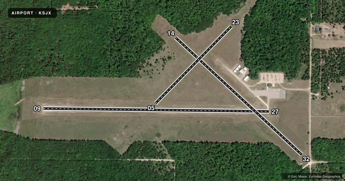
Runways & pattern
Full pagePattern entry · RWY 23
LEFT TRAFFIC| Runway | Heading (°M) | Length | Surface | Traffic |
|---|---|---|---|---|
| 09/27 | 86° / 266° | 4,299 ft | ASPH | Standard L |
| 14/32 | 128° / 308° | 3,278 ft | TURF | Standard L |
| 05/23Favored | 40° / 220° | 2,054 ft | TURF | Standard L |
Runway end performance
| End | TORA | TODA | ASDA | LDA | VGSI | Approach lights | Obstruction |
|---|---|---|---|---|---|---|---|
| 09 | — | — | — | — | PAPI 4-box left(3°) | — | — |
| 27 | — | — | — | — | PAPI 4-box left(4°) | — | 67', tree, 1010' from thr, 330' R of cntrln, slope 12 |
| 14 | — | — | — | — | — | — | 70', trees, 0' from thr, 125' R of cntrln, slope 0 |
| 32 | — | — | — | — | — | — | 15', road, 75' from thr, 133' R of cntrln, slope 5 |
| 05 | — | — | — | — | — | — | 82', trees, 1238' from thr, 0' R of cntrln, slope 15 |
| 23 | — | — | — | — | — | — | 49', trees, 230' from thr, 130' R of cntrln, slope 4 |
Declared distances in feet. TORA = takeoff run available, TODA = takeoff distance, ASDA = accelerate-stop, LDA = landing distance.
Airport sketch
Runways drawn to scale from FAA survey coordinates, rendered over satellite imagery. Not for navigation.
Approaches & charts
Services on the field
Fuel grades, oxygen, maintenance, ramp storage and lighting — as declared to the FAA by the airport operator.
Fuel & services
- Fuel
- 100LL
- Oxygen (bottled)
- Not available
- Oxygen (bulk)
- Not available
- Airframe repair
- Not available
- Power plant repair
- Not available
- Other services
- CHTR
Ramp & ground
- Transient storage
- Tie-down
- Landing fee
- No fee published
- Customs
- Not available
- Lighting schedule
- SEE RMK
- Beacon schedule
- SS-SR
- Beacon
- White / Green (civil land)(WG)
- Wind indicator
- Lighted
- Segmented circle
- Yes
Fuel & FBOs
Cheapest 100LL and Jet A on the field and nearby. Always confirm with the FBO before taxi.
Airport notes
Surface conditions, obstructions, local procedures, lighting outages and other notes published with each FAA cycle.
General notes
- DEER & BIRDS ON & INVOF ARPT.
- FOR CD CTC MINNEAPOLIS ARTCC AT 651-463-5588.
Lighting notes
- ACTVT REIL RWY 09 & 27; PAPI RWY 09 & 27; MIRL RWY 09/27 - CTAF.
Runway surface & condition
- 05/23CLSD NOV-APR & WHEN SNOW COVD.
- 14/32CLSD NOV-APR & WHEN SNOW COVD.
Approach & departure obstructions
- 053 FT YELLOW CONES.
- 143 FT YELLOW CONES; DTHR MKD WITH 3 CONES EACH SIDE.
- 233 FT YELLOW CONES; DTHR MKD WITH 3 CONES EACH SIDE.
- 323 FT YELLOW CONES; DTHR MKD WITH 3 CONES EACH SIDE.
- 14APCH RATIO 6:1 TO DTHR.
- 23APCH RATIO 17:1 TO DTHR.
- 32APCH RATIO 13:1 TO DTHR.
Other notes
- NON-COMPLIANCE WITH FAR 157.
- 2UNATNDD THANKSGIVING & CHRISTMAS.
- MANAGERCELL 231-675-5391.
VFR map & nearby airports
VFR sectional. Tap any ICAO chip to open that airport.
Key facts · KSJX
Answer card- ICAO
- KSJX
- Name
- BEAVER ISLAND
- Location
- BEAVER ISLAND, MICHIGAN
- Elevation
- 669.8 ft MSL
- Traffic pattern altitude
- 1,669.8 ft MSL (1,000 AGL)
- Control tower
- Non-towered (use CTAF)
- Total runways
- 3
- Longest runway
- 09/27 · 4,299 ft
- Published ILS approaches
- 0
- Published frequencies
- 2
- Magnetic variation
- 5°
- Current flight rules
- MVFR
- Current wind
- 230° at 11 kt
- Favored runway now
- RWY 23
Beaver Island Airport sits on Beaver Island in Michigan. Field elevation is 669.8 ft MSL. The airport has three runways. The longest is 09/27 at 4,299 ft asphalt. The field is unattended, so plan to self-announce on CTAF 122.8. UNICOM is also 122.8. No ILS approaches are published here.
Pattern altitude is not published. Use 1,000 ft AGL for light piston operations unless the current Chart Supplement or local procedures say otherwise. That puts the traffic pattern about 1,670 ft MSL based on the published field elevation. Runway 09/27 has medium intensity lighting controlled by CTAF. It also has runway end identifier lights and PAPI. Runway 23 has displaced threshold markings. Deer and birds are reported on and near the airport, so keep a sharp scan on arrival and departure.
Beaver Island Airport has one on-field FBO. Beaver Island Airport carries AVGAS 100LL. Call the field directly at (231) 448-2750 before you go. Runway 14/32 is closed from November through April and when snow covered. Runway 05/23 is also closed from November through April and when snow covered. For clearance delivery, contact Minneapolis ARTCC at 651-463-5588. The airport manager can be reached at 231-675-5391. Check the current Chart Supplement for any other operational notes before flying in.