METAR & TAF 83D
83D does not publish a METAR.
Showing the nearest reporting station: KMCD (MACKINAC ISLAND) · 4.5 NM away. Conditions at 83D may differ.
METAR · KMCD
Observed 19:55Z
KMCD 271955Z AUTO 10004KT 5SM HZ BKN010 24/22 A2969 RMK AO2
- Wind
- 100° @ 4 kt
- Visibility
- 5 SM
- Temp / Dew
- 24°C / 22°C
- Altimeter
- 29.69 inHg
- Clouds
- BKN
- Density alt
- 2,138 ft
- Ceiling
- 1,000 ft AGL
- Rules
- MVFR
Airport info & contacts
Manager on record, flight service, ARTCC, attendance schedule and pattern altitude — published by the FAA and refreshed every 28 days.
Location
- From city
- 1 NM NNW
- VFR sectional
- LAKE HURON
- ARTCC
- ZMP · MINNEAPOLIS
- NOTAM facility
- GRB (NOTAM-D)
Airport manager
- Name
- PAUL S FULLERTON
- Phone
- 906-643-7327
- Address
- 1220 N STATE ST, SAINT IGNACE MI 49781-1014
Flight service · Hours
- FSS GRB
- GREEN BAY1-800-WX-BRIEF
- Attendance
- DAWN-DUSK
Frequencies
Tap any row to copy the frequency to your clipboard.
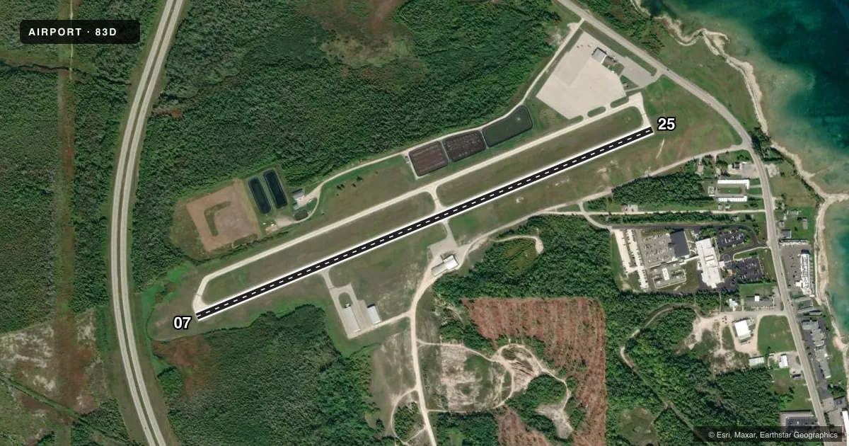
Runways & pattern
Full pagePattern entry · RWY 07
LEFT TRAFFICRunway end performance
| End | TORA | TODA | ASDA | LDA | VGSI | Approach lights | Obstruction |
|---|---|---|---|---|---|---|---|
| 07 | — | — | — | — | PAPI 4-box left(4°) | — | 14', brush, 387' from thr, 209' R of cntrln, slope 13 |
| 25 | — | — | — | — | PAPI 4-box left(3.04°) | — | — |
Declared distances in feet. TORA = takeoff run available, TODA = takeoff distance, ASDA = accelerate-stop, LDA = landing distance.
Airport sketch
Runways drawn to scale from FAA survey coordinates, rendered over satellite imagery. Not for navigation.
Approaches & charts
Services on the field
Fuel grades, oxygen, maintenance, ramp storage and lighting — as declared to the FAA by the airport operator.
Fuel & services
- Fuel
- 100LLA+
- Oxygen (bottled)
- Not available
- Oxygen (bulk)
- Not available
- Airframe repair
- Major
- Power plant repair
- Major
- Other services
- CHTR
Ramp & ground
- Transient storage
- Tie-down
- Hangar
- Landing fee
- No fee published
- Customs
- Not available
- Lighting schedule
- SEE RMK
- Beacon schedule
- SS-SR
- Beacon
- White / Green (civil land)(WG)
- Wind indicator
- Yes
Fuel & FBOs
Cheapest 100LL and Jet A on the field and nearby. Always confirm with the FBO before taxi.
Airport notes
Surface conditions, obstructions, local procedures, lighting outages and other notes published with each FAA cycle.
General notes
- DEER, BIRDS, & WILDLIFE ON & INVOF ARPT.
- MCD AWOS FREQ CAN BE RCVD ON THE GND.
- RADIO CALL "SAINT IGNACE."
- FOR CD CTC MINNEAPOLIS ARTCC AT 651-463-5588.
Lighting notes
- ACTVT REIL RWY 07 & 25; PAPI RWY 07 & 25; MIRL RWY 07/25; RAMP LGTS - CTAF.
Approach & departure obstructions
- 075-10 FT BRUSH, 150-199 FT DIST, 240 FT L.
Other notes
- ESTABD BFR 1959.
- 1FOR SVC AFT HRS CALL AMGR RES AT 906-643-7161.
VFR map & nearby airports
VFR sectional. Tap any ICAO chip to open that airport.
Key facts · 83D
Answer card- ICAO
- 83D
- Name
- MACKINAC COUNTY
- Location
- ST IGNACE, MICHIGAN
- Elevation
- 623.5 ft MSL
- Traffic pattern altitude
- 1,623.5 ft MSL (1,000 AGL)
- Control tower
- Non-towered (use CTAF)
- Total runways
- 1
- Longest runway
- 07/25 · 3,800 ft
- Published ILS approaches
- 0
- Published frequencies
- 2
- Magnetic variation
- 6°
- Current flight rules
- MVFR
- Current wind
- 100° at 4 kt
- Favored runway now
- RWY 07
Mackinac County Airport sits in St Ignace, Michigan. The field elevation is 623.5 ft MSL. It has one runway. Runway 07/25 is 3,800 ft long with a concrete surface. The airport is non-towered. Radio calls use Saint Ignace. CTAF and UNICOM are both 122.7.
No ILS approaches are published here. Pattern altitude is not published in the facts. Use the standard 1,000 ft AGL for light piston operations unless the current Chart Supplement shows otherwise. The on-field FBO is Mackinac County Airport. It carries 100LL and Jet A Prist. Call (906) 643-7327 for current service details.
A few operational items matter here. Runway end identifier lights are active on 07 and 25. PAPI and medium intensity runway lights are installed on the runway. Ramp lights are controlled by the CTAF. Wildlife is a real factor here. Deer, birds and other wildlife are reported on and near the airport. There is also brush near runway 07, about 150 to 199 ft from the runway and 240 ft left of centerline. For after-hours service, call the airport manager’s residence at 906-643-7161. If you need clearance delivery, contact Minneapolis ARTCC at 651-463-5588.