METAR & TAF KMCD
Current METAR
Observed 03:15Z
KMCD 140315Z AUTO 31004KT 10SM OVC085 14/08 A2979 RMK AO2
- Wind
- 310° @ 4 kt
- Visibility
- 10 SM
- Temp / Dew
- 14°C / 8°C
- Altimeter
- 29.79 inHg
- Clouds
- OVC
- Density alt
- 960 ft
- Ceiling
- 8,500 ft AGL
- Rules
- VFR
Airport info & contacts
Manager on record, flight service, ARTCC, attendance schedule and pattern altitude — published by the FAA and refreshed every 28 days.
Location
- From city
- 1 NM NW
- VFR sectional
- LAKE HURON
- Pattern altitude
- 1,159 ft AGL · 1,900 ft MSL
- ARTCC
- ZMP · MINNEAPOLIS
- NOTAM facility
- MCD (NOTAM-D)
Airport manager
- Name
- MYRON JOHNSON
- Phone
- 906-847-3231
- Address
- PO BOX 370, MACKINAC ISLAND MI 49757-0370
Flight service · Hours
- FSS GRB
- GREEN BAY1-800-WX-BRIEF
- Attendance
- 0800-1700
Frequencies
Tap any row to copy the frequency to your clipboard.
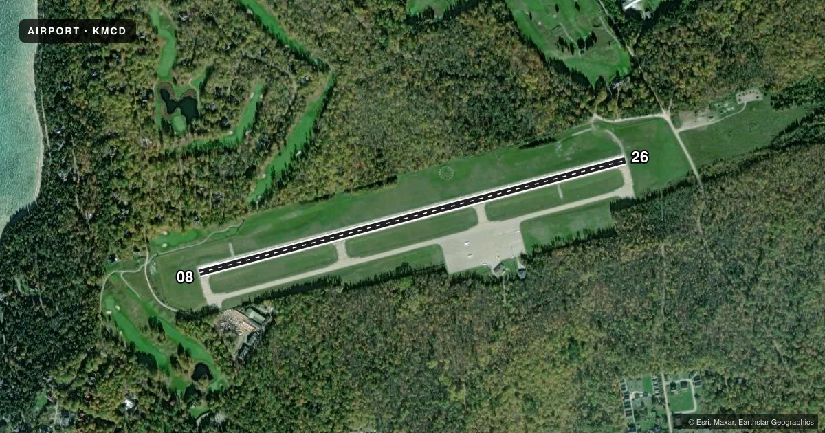
Runways & pattern
Full pagePattern entry · RWY 26
LEFT TRAFFICRunway end performance
| End | TORA | TODA | ASDA | LDA | VGSI | Approach lights | Obstruction |
|---|---|---|---|---|---|---|---|
| 08 | — | — | — | — | PAPI 4-box left(3.5°) | — | 29', tree, 374' from thr, 290' R of cntrln, slope 6 |
| 26 | — | — | — | — | PAPI 4-box left(3.8°) | — | 34', tree, 491' from thr, 275' R of cntrln, slope 8 |
Declared distances in feet. TORA = takeoff run available, TODA = takeoff distance, ASDA = accelerate-stop, LDA = landing distance.
Airport sketch
Runways drawn to scale from FAA survey coordinates, rendered over satellite imagery. Not for navigation.
Approaches & charts
Services on the field
Fuel grades, oxygen, maintenance, ramp storage and lighting — as declared to the FAA by the airport operator.
Fuel & services
- Fuel
- Not available
- Oxygen (bottled)
- Not available
- Oxygen (bulk)
- Not available
- Airframe repair
- Not available
- Power plant repair
- Not available
Ramp & ground
- Transient storage
- Tie-down
- Landing fee
- Yes
- Customs
- Not available
- Lighting schedule
- SEE RMK
- Beacon schedule
- SS-SR
- Beacon
- White / Green (civil land)(WG)
- Wind indicator
- Lighted
- Segmented circle
- Yes
Fuel & FBOs
Cheapest 100LL and Jet A on the field and nearby. Always confirm with the FBO before taxi.
Airport notes
Surface conditions, obstructions, local procedures, lighting outages and other notes published with each FAA cycle.
General notes
- LRG BIRDS ON & INVOF ARPT; FLOCKS OF SEAGULLS INVOF LANDFILL 0.3 NM NE.
- NOISE ABATEMENT PROCS: CLIMB TO TPA BFR TURNING; AVD FLT OVR SHORE & TOWN; TGL NA.
- OBSTN LGTS ARE IN THE APCH TO RWY 26.
- PITOT COVS RCMDD WHILE PARKED; CK TUBES BFR DEP DUE TO MUD DAUBERS.
- FOR CD CTC MINNEAPOLIS ARTCC AT 651-463-5588.
Lighting notes
- ACTVT REIL RWY 08 & 26; PAPI RWY 08 & 26; MIRL RWY 08/26 - 122.8.
Approach & departure obstructions
- 08+4 FT FENCE, 0 FT DIST, 210 FT L/R.
- 08PAPI UNUSBL BYD 5 DEGS LEFT OF CNTRLN.
- 26PAPI UNUSBL BYD 5 DEGS LEFT OF CNTRLN.
VFR map & nearby airports
VFR sectional. Tap any ICAO chip to open that airport.
Key facts · KMCD
Answer card- ICAO
- KMCD
- Name
- MACKINAC ISLAND
- Location
- MACKINAC ISLAND, MICHIGAN
- Elevation
- 741 ft MSL
- Traffic pattern altitude
- 1,900 ft MSL (1,159 AGL)
- Control tower
- Non-towered (use CTAF)
- Total runways
- 1
- Longest runway
- 08/26 · 3,501 ft
- Published ILS approaches
- 0
- Published frequencies
- 2
- Magnetic variation
- 7°
- Current flight rules
- VFR
- Current wind
- 310° at 4 kt
- Favored runway now
- RWY 26
Mackinac Island Airport (KMCD) sits on Mackinac Island, Michigan. Field elevation is 741 ft MSL. The airport has one runway, 08/26, which is 3,501 ft long and asphalt. There is no control tower. CTAF and UNICOM are both 122.7. No ILS approaches are published here.
Pattern altitude is 1,159 ft AGL. That is 1,900 ft MSL. Use the published pattern and stay sharp on the noise abatement. Climb to pattern altitude before turning. Avoid flight over the shore and town. Touch-and-go landings are not authorized.
The published remarks also call out bird activity. Large birds are on and near the airport. Seagulls are also near the landfill 0.3 NM northeast. Expect that to matter on arrival and departure. There is also a fence near runway 08. Obstacle lights are reported in the approach to runway 26. The PAPI is unusable beyond 5 degrees left of centerline on both runway 08 and runway 26.
No on-field FBOs are listed in the facts. Contact the airport operator or the FBO directly by phone before arrival for current service details. For clearance delivery, contact Minneapolis ARTCC at 651-463-5588.