METAR & TAF KCIU
Current METAR
Observed 19:31Z
KCIU 271931Z AUTO 19008KT 10SM BKN017 26/22 A2970 RMK AO2 $
- Wind
- 190° @ 8 kt
- Visibility
- 10 SM
- Temp / Dew
- 26°C / 22°C
- Altimeter
- 29.70 inHg
- Clouds
- BKN
- Density alt
- 2,584 ft
- Ceiling
- 1,700 ft AGL
- Rules
- MVFR
Airport info & contacts
Manager on record, flight service, ARTCC, attendance schedule and pattern altitude — published by the FAA and refreshed every 28 days.
Location
- From city
- 15 NM S
- VFR sectional
- LAKE HURON
- Pattern altitude
- 800 ft AGL · 1,599 ft MSL
- ARTCC
- ZYZ · TORONTO
- NOTAM facility
- CIU (NOTAM-D)
Airport manager
- Name
- TAMI L BESEAU
- Phone
- 906-495-5631
- Address
- 5019 W AIRPORT DR, KINCHELOE MI 49788-1643
Flight service · Hours
- FSS GRB
- GREEN BAY1-800-WX-BRIEF
- Attendance
- 0600-1800
Frequencies
Tap any row to copy the frequency to your clipboard.
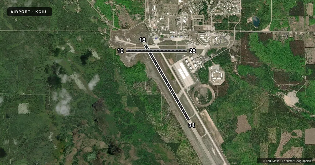
Runways & pattern
Full pagePattern entry · RWY 16
RIGHT TRAFFIC| Runway | Heading (°M) | Length | Surface | Traffic |
|---|---|---|---|---|
| 16/34Favored | 143° / 323° | 7,203 ft | ASPH-CONC | 16 R |
| 10/28 | 83° / 263° | 5,001 ft | ASPH | Standard L |
Runway end performance
| End | TORA | TODA | ASDA | LDA | VGSI | Approach lights | Obstruction |
|---|---|---|---|---|---|---|---|
| 16 | 7,203' | 7,203' | 7,203' | 7,203' | PAPI 4-box left(3°) | MALSR | — |
| 34 | 7,203' | 7,203' | 7,203' | 7,203' | PAPI 4-box left(3°) | — | — |
| 10 | 5,000' | 5,000' | 5,000' | 5,000' | PAPI 4-box left(3°) | — | 57', trees, 1900' from thr, 50' R of cntrln, slope 29 |
| 28 | 5,000' | 5,000' | 5,000' | 5,000' | PAPI 4-box left(3°) | — | 51', trees, 1800' from thr, 200' R of cntrln, slope 31 |
Declared distances in feet. TORA = takeoff run available, TODA = takeoff distance, ASDA = accelerate-stop, LDA = landing distance.
Airport sketch
Runways drawn to scale from FAA survey coordinates, rendered over satellite imagery. Not for navigation.
Approaches & charts
ILS · 1
Services on the field
Fuel grades, oxygen, maintenance, ramp storage and lighting — as declared to the FAA by the airport operator.
Fuel & services
- Fuel
- 100LLA
- Oxygen (bottled)
- Not available
- Oxygen (bulk)
- Not available
Ramp & ground
- Transient storage
- Tie-down
- Hangar
- Landing fee
- No fee published
- Customs
- Not available
- Lighting schedule
- SEE RMK
- Beacon schedule
- SS-SR
- Beacon
- White / Green (civil land)(WG)
- Wind indicator
- Lighted
- Segmented circle
- Yes
Fuel & FBOs
Cheapest 100LL and Jet A on the field and nearby. Always confirm with the FBO before taxi.
Airport notes
Surface conditions, obstructions, local procedures, lighting outages and other notes published with each FAA cycle.
General notes
- BIRDS ON & INVOF ARPT.
- EXP SNOW REMOVAL ACT DLY DEC-MAR.
- VEHICLE TESTING INPR DRG WINTER MONTHS ON SECTIONS OF CLSD/ABNDD PARL TWY, SE OF APCH END RWY 34. AREA MAY BE PLOWED TO BARE SFC BUT UNAVBL FOR ARR OR DEP.
- FICONS UNMON 2100-0700.
- FOR CD IF UNA TO CTC ON FSS FREQ, CTC MINNEAPOLIS ARTCC AT 651-463-5588.
Lighting notes
- ACTVT MALSR RWY 16; REIL RWY 34, 10, & 28; PAPI RWY 16, 34, 10, & 28; HIRL RWY 16/34; MIRL RWY 10/28 - CTAF. REIL & PAPI RWY 34 OPR CONSLY DEC-MAR; PAPI RWY 10 & 28 OPR CONSLY DRG DALGT HRS.
Runway surface & condition
- 10/28PCR VALUE: 200/F/B/X/T
- 16/34PCR VALUE: 680/R/B/W/T
Approach & departure obstructions
- 28PAPI UNUSBL BYD 8 DEGS LEFT OF CNTRLN.
Other notes
- 24 HR PPR FOR UNSKED ACR OPS GTR THAN 9 PAX SEATS - CALL AMGR.
- MANAGERAFT HRS CELL 906-322-3651.
- 16/34CNTR 150 FT IS ASPH, RMNG OUTSIDE EDGES ARE CONC.
VFR map & nearby airports
VFR sectional. Tap any ICAO chip to open that airport.
Key facts · KCIU
Answer card- ICAO
- KCIU
- Name
- CHIPPEWA COUNTY INTL
- Location
- SAULT STE MARIE, MICHIGAN
- Elevation
- 799.3 ft MSL
- Traffic pattern altitude
- 1,599.3 ft MSL (800 AGL)
- Control tower
- Non-towered (use CTAF)
- Total runways
- 2
- Longest runway
- 16/34 · 7,203 ft
- Published ILS approaches
- 1
- Published frequencies
- 2
- Magnetic variation
- 7°
- Current flight rules
- MVFR
- Current wind
- 190° at 8 kt
- Favored runway now
- RWY 16
Chippewa County Intl sits in Sault Ste Marie, Michigan. Field elevation is 799.3 ft MSL. The airport has two runways. The longest is 7,203 ft. There is no control tower, so expect CTAF and UNICOM self-announce traffic. Pattern altitude is 800 ft AGL, which is 1,599.3 ft MSL.
Runway 16 has the ILS. That is the main precision option here. The field also has runway 10/28 at 5,001 ft. The airport is in a winter climate. Snow removal is active from December through March. Birds are also reported on and near the airport. Keep an eye out on taxi, takeoff and final.
Chippewa County International Airport is the on-field FBO. It carries 100LL and Jet A with Prist. Call (906) 495-3835 for current service details. After hours manager contact is 906-322-3651. The published remarks also note that runway 34 lighting and PAPI operate continuously from December through March. If you are flying a larger unscheduled aircraft with more than nine passenger seats, 24-hour prior permission is required. Check the current FAA Chart Supplement for any current operational notes before you go.