METAR & TAF 6Y1
6Y1 does not publish a METAR.
Showing the nearest reporting station: KSLH (CHEBOYGAN COUNTY) · 6.8 NM away. Conditions at 6Y1 may differ.
METAR · KSLH
Observed 13:35Z
KSLH 271335Z AUTO 26007KT 10SM OVC012 25/22 A2970 RMK AO2
- Wind
- 260° @ 7 kt
- Visibility
- 10 SM
- Temp / Dew
- 25°C / 22°C
- Altimeter
- 29.70 inHg
- Clouds
- OVC
- Density alt
- 2,296 ft
- Ceiling
- 1,200 ft AGL
- Rules
- MVFR
Airport info & contacts
Manager on record, flight service, ARTCC, attendance schedule and pattern altitude — published by the FAA and refreshed every 28 days.
Location
- From city
- 3 NM NW
- VFR sectional
- LAKE HURON
- ARTCC
- ZMP · MINNEAPOLIS
- NOTAM facility
- LAN (NOTAM-D)
Airport manager
- Name
- CHRISTOPHER VIERS
- Phone
- 812-320-0792
- Address
- 2431 BRIDGE VIEW DR, BOIS BLANC ISLAND MI 49775-0898
Flight service · Hours
- FSS LAN
- LANSING1-800-WX-BRIEF
- Attendance
- Unattended
Frequencies
Tap any row to copy the frequency to your clipboard.
Runways & pattern
Full pagePattern entry · RWY 28
LEFT TRAFFICRunway end performance
| End | TORA | TODA | ASDA | LDA | VGSI | Approach lights | Obstruction |
|---|---|---|---|---|---|---|---|
| 28 | — | — | — | — | PAPI 4-box left(4°) | — | — |
Declared distances in feet. TORA = takeoff run available, TODA = takeoff distance, ASDA = accelerate-stop, LDA = landing distance.
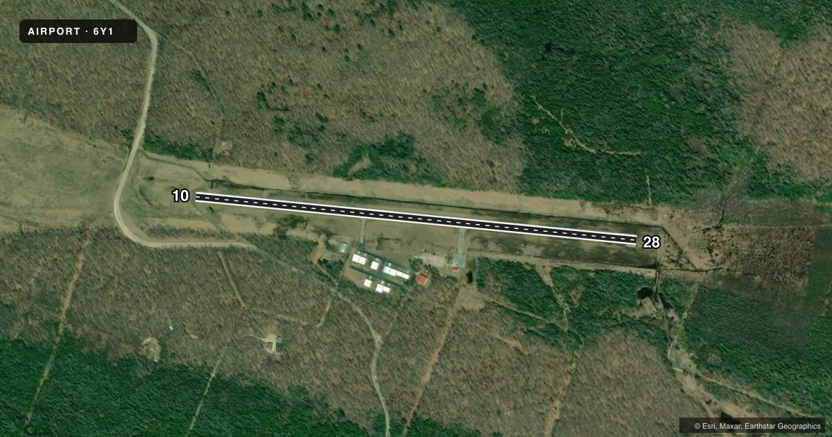
Airport sketch
Runways drawn to scale from FAA survey coordinates, rendered over satellite imagery. Not for navigation.
Approaches & charts
Services on the field
Fuel grades, oxygen, maintenance, ramp storage and lighting — as declared to the FAA by the airport operator.
Fuel & services
- Fuel
- Not available
Ramp & ground
- Transient storage
- Tie-down
- Landing fee
- No fee published
- Customs
- Not available
- Lighting schedule
- SEE RMK
- Beacon schedule
- SS-SR
- Beacon
- White / Green (civil land)(WG)
- Wind indicator
- Lighted
- Segmented circle
- No
Fuel & FBOs
Cheapest 100LL and Jet A on the field and nearby. Always confirm with the FBO before taxi.
Airport notes
Surface conditions, obstructions, local procedures, lighting outages and other notes published with each FAA cycle.
General notes
- DEER, BIRDS, & WILDLIFE ON & INVOF ARPT.
- TO VFY FICON CALL AMGR.
- FOR CD CTC MINNEAPOLIS ARTCC AT 651-463-5588.
Lighting notes
- ACTVT REIL RWY 28; PAPI RWY 28; MIRL RWY 10/28 - CTAF.
Other notes
- 1FOR SVC CALL AMGR.
- MANAGEROR 231-634-7052.
VFR map & nearby airports
VFR sectional. Tap any ICAO chip to open that airport.
Key facts · 6Y1
Answer card- ICAO
- 6Y1
- Name
- BOIS BLANC ISLAND
- Location
- BOIS BLANC ISLAND, MICHIGAN
- Elevation
- 664 ft MSL
- Traffic pattern altitude
- 1,664 ft MSL (1,000 AGL)
- Control tower
- Non-towered (use CTAF)
- Total runways
- 1
- Longest runway
- 10/28 · 3,498 ft
- Published ILS approaches
- 0
- Published frequencies
- 1
- Magnetic variation
- 6°
- Current flight rules
- MVFR
- Current wind
- 260° at 7 kt
- Favored runway now
- RWY 28
Bois Blanc Island Airport sits on Bois Blanc Island in Michigan. Field elevation is 664 ft MSL. The airport has one runway, 10/28, which is 3,498 ft long and asphalt. There is no control tower. CTAF is 122.9.
No ILS approaches are published here. Pattern altitude is not published, so use the standard 1,000 ft AGL for light piston aircraft unless the current Chart Supplement says otherwise. Runway lighting is tied to CTAF. Runway 28 has runway end identifier lights and a precision approach path indicator. Runways 10 and 28 have medium intensity runway lights.
There are no on-field FBOs listed. For service, call the airport manager. The published remarks also say to verify field condition with the airport manager before you go. Deer, birds and other wildlife are reported on and near the airport, so plan your arrival and departure with that in mind. For clearance delivery, contact Minneapolis ARTCC. If you need current operational details, use the current FAA Chart Supplement or call the airport manager directly.