METAR & TAF KSLH
Current METAR
Observed 19:15Z
KSLH 271915Z AUTO VRB04KT 10SM SCT011 OVC120 25/21 A2969 RMK AO2
- Wind
- VAR @ 4 kt
- Visibility
- 10 SM
- Temp / Dew
- 25°C / 21°C
- Altimeter
- 29.69 inHg
- Clouds
- OVC
- Density alt
- 2,278 ft
- Ceiling
- 12,000 ft AGL
- Rules
- VFR
Airport info & contacts
Manager on record, flight service, ARTCC, attendance schedule and pattern altitude — published by the FAA and refreshed every 28 days.
Location
- From city
- 2 NM W
- VFR sectional
- LAKE HURON
- ARTCC
- ZMP · MINNEAPOLIS
- NOTAM facility
- SLH (NOTAM-D)
Airport manager
- Name
- MICHAEL JERMEAY
- Phone
- 231-627-5571
- Address
- 1520 LEVERING RD, CHEBOYGAN MI 49721-9381
Flight service · Hours
- FSS LAN
- LANSING1-800-WX-BRIEF
- Attendance
- MON-FRI · 0800-1600
- SAT-SUN · ON-CALL
Frequencies
Tap any row to copy the frequency to your clipboard.
Runways & pattern
Full pagePattern entry · RWY 35
LEFT TRAFFIC| Runway | Heading (°M) | Length | Surface | Traffic |
|---|---|---|---|---|
| 10/28 | 83° / 263° | 4,004 ft | ASPH | Standard L |
| 17/35Favored | 158° / 338° | 1,874 ft | ASPH | Standard L |
Runway end performance
| End | TORA | TODA | ASDA | LDA | VGSI | Approach lights | Obstruction |
|---|---|---|---|---|---|---|---|
| 10 | — | — | — | — | PAPI 2-box left(4°) | — | 19', road, 380' from thr, 276' R of cntrln, slope 9 |
| 28 | — | — | — | — | PAPI 2-box left(4°) | — | 7', trees, 268' from thr, 266' R of cntrln, slope 9 |
| 35 | — | — | — | — | — | — | 83', trees, 1427' from thr, 248' R of cntrln, slope 14 |
Declared distances in feet. TORA = takeoff run available, TODA = takeoff distance, ASDA = accelerate-stop, LDA = landing distance.
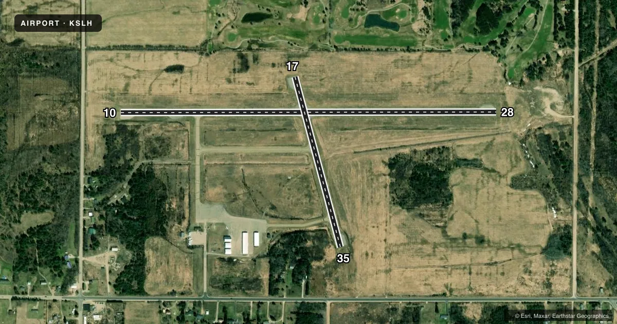
Airport sketch
Runways drawn to scale from FAA survey coordinates, rendered over satellite imagery. Not for navigation.
Approaches & charts
Services on the field
Fuel grades, oxygen, maintenance, ramp storage and lighting — as declared to the FAA by the airport operator.
Fuel & services
- Fuel
- 100LLA+
- Airframe repair
- Major
- Power plant repair
- Major
- Other services
- INSTR,RNTL
Ramp & ground
- Transient storage
- Not published
- Landing fee
- No fee published
- Customs
- Not available
- Lighting schedule
- SEE RMK
- Beacon schedule
- SS-SR
- Beacon
- White / Green (civil land)(WG)
- Wind indicator
- Lighted
- Segmented circle
- Yes
Fuel & FBOs
Cheapest 100LL and Jet A on the field and nearby. Always confirm with the FBO before taxi.
Airport notes
Surface conditions, obstructions, local procedures, lighting outages and other notes published with each FAA cycle.
General notes
- DEER, BIRDS, & WILDLIFE ON & INVOF ARPT.
- AFT HRS TRML BLDG ACES: PRESS 5, THEN 3 & 2 SIMUL, THEN 1.
- FOR CD CTC MINNEAPOLIS ARTCC AT 651-463-5588.
Lighting notes
- ACTVT REIL RWY 10 & 28; PAPI RWY 10 & 28; MIRL RWY 10/28 & 17/35 - CTAF.
Fuel notes
- 100LL100LL AVBL H24 SELF SVC. FOR JET A AFT HRS CALL 989-464-6887 SUBJ CALL-IN FEE.
Other notes
- 2UNATNDD CHRISTMAS, EASTER, & THANKSGIVING OR BY ARNGMT.
- 4SVCS PRVDD WKENDS BY PRIOR ARNGMT.
- MANAGERCELL 989-464-6887.
VFR map & nearby airports
VFR sectional. Tap any ICAO chip to open that airport.
Key facts · KSLH
Answer card- ICAO
- KSLH
- Name
- CHEBOYGAN COUNTY
- Location
- CHEBOYGAN, MICHIGAN
- Elevation
- 639.7 ft MSL
- Traffic pattern altitude
- 1,639.7 ft MSL (1,000 AGL)
- Control tower
- Non-towered (use CTAF)
- Total runways
- 2
- Longest runway
- 10/28 · 4,004 ft
- Published ILS approaches
- 0
- Published frequencies
- 2
- Magnetic variation
- 7°
- Current flight rules
- VFR
- Current wind
- 000° at 4 kt
- Favored runway now
- RWY 35
Cheboygan County Airport (KSLH) sits in Cheboygan, Michigan at 639.7 ft MSL. It has two asphalt runways. The longest is 10/28 at 4,004 ft. The other runway is 17/35 at 1,874 ft. There is no control tower, so plan to self-announce on CTAF 122.8. UNICOM is also 122.8. No ILS approaches are published here.
Pattern altitude is not published. For light piston operations, use the standard 1,000 ft AGL unless the current Chart Supplement says otherwise. That puts the pattern at about 1,640 ft MSL based on the field elevation. Verify before you fly. The field is in northern Michigan near the shoreline. Wildlife is a real factor here. The published remarks call out deer, birds and other wildlife on and near the airport.
Cheboygan County Airport is the on-field FBO. It carries AVGAS 100LL. 100LL is available 24 hours by self-serve. After hours terminal access is available by a published keypad sequence. Weekend service is by prior arrangement. For clearance delivery, the published contact is Minneapolis ARTCC. Runway end identifier lights and PAPI are on runway 10/28. Medium intensity runway lights are on both runways and are CTAF controlled.