METAR & TAF Y65
Y65 does not publish a METAR.
Showing the nearest reporting station: KPLN (PELLSTON RGNL/EMMET COUNTY) · 12.9 NM away. Conditions at Y65 may differ.
METAR · KPLN
Observed 23:54Z
KPLN 242354Z AUTO 18004KT 10SM CLR 18/12 A2998 RMK AO2 SLP154 60030 T01780117 10222 20161 56010
- Wind
- 180° @ 4 kt
- Visibility
- 10 SM
- Temp / Dew
- 18°C / 12°C
- Altimeter
- 29.98 inHg
- Clouds
- CLR
- Density alt
- 1,047 ft
- Ceiling
- Unlimited
- Rules
- VFR
Airport info & contacts
Manager on record, flight service, ARTCC, attendance schedule and pattern altitude — published by the FAA and refreshed every 28 days.
Location
- From city
- 1 NM E
- VFR sectional
- LAKE HURON
- ARTCC
- ZMP · MINNEAPOLIS
- NOTAM facility
- LAN (NOTAM-D)
Airport manager
- Name
- MARK MACHOWICZ
- Phone
- 586-899-8115
- Address
- 24844 MARINE AVE, EAST POINTE MI 48021-1455
Flight service · Hours
- FSS LAN
- LANSING1-800-WX-BRIEF
- Attendance
- IREG
Frequencies
Tap any row to copy the frequency to your clipboard.
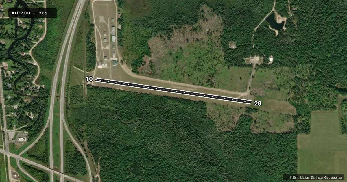
Runways & pattern
Full pagePattern entry · RWY 10
LEFT TRAFFICRunway end performance
| End | TORA | TODA | ASDA | LDA | VGSI | Approach lights | Obstruction |
|---|---|---|---|---|---|---|---|
| 10 | — | — | — | — | — | — | 71', trees, 1350' from thr, 204' R of cntrln, slope 16 |
| 28 | — | — | — | — | — | — | 5', gnd, 200' from thr, 0' R of cntrln, slope 0 |
Declared distances in feet. TORA = takeoff run available, TODA = takeoff distance, ASDA = accelerate-stop, LDA = landing distance.
Airport sketch
Runways drawn to scale from FAA survey coordinates, rendered over satellite imagery. Not for navigation.
Approaches & charts
Services on the field
Fuel grades, oxygen, maintenance, ramp storage and lighting — as declared to the FAA by the airport operator.
Fuel & services
- Fuel
- Not available
Ramp & ground
- Transient storage
- Tie-down
- Landing fee
- No fee published
- Lighting schedule
- SEE RMK
- Wind indicator
- Lighted
- Segmented circle
- Yes
Fuel & FBOs
Cheapest 100LL and Jet A on the field and nearby. Always confirm with the FBO before taxi.
Airport notes
Surface conditions, obstructions, local procedures, lighting outages and other notes published with each FAA cycle.
General notes
- DEER, BIRDS, & WILDLIFE ON & INVOF ARPT.
- SNOW REMOVAL INTMT, FOR FICONS CTC ASST AMGR 517-242 -8236.
- FOR CD CTC MINNEAPOLIS ARTCC AT 651-463-5588.
Lighting notes
- ACTVT LIRL RWY 10/28 - CTAF.
Approach & departure obstructions
- 28CTLG OBSTN EXCEEDS A 45 DEG SLP.
Other notes
- ESTABD BFR 1959.
- 1FOR SVC CTC ASST AMGR 517-242-8236.
VFR map & nearby airports
VFR sectional. Tap any ICAO chip to open that airport.
Key facts · Y65
Answer card- ICAO
- Y65
- Name
- CAMPBELL-PRATT
- Location
- INDIAN RIVER, MICHIGAN
- Elevation
- 614 ft MSL
- Traffic pattern altitude
- 1,614 ft MSL (1,000 AGL)
- Control tower
- Non-towered (use CTAF)
- Total runways
- 1
- Longest runway
- 10/28 · 3,005 ft
- Published ILS approaches
- 0
- Published frequencies
- 1
- Magnetic variation
- –
- Current flight rules
- VFR
- Current wind
- 180° at 4 kt
- Favored runway now
- RWY 10
Campbell-Pratt Airport is in Indian River, Michigan. Field elevation is 614 ft MSL. The airport has one runway. Runway 10/28 is 3,005 ft long with asphalt pavement. There is no control tower, so use CTAF 122.9 for traffic calls.
No ILS approaches are published here. Pattern altitude is not published, so use the current Chart Supplement before you fly. Low intensity runway lights on 10/28 are activated by CTAF. That helps for night operations. You still need to verify the lighting setup before arrival.
There are no on-field FBOs listed in the facts. Contact the airport operator or the field directly for current service options before you go. Published remarks also note deer, birds and other wildlife in the area. Snow removal is intermittent. For FICONs, call the assistant manager. Clearance delivery is handled through Minneapolis ARTCC at 651-463-5588. Runway 28 also has a cataloged obstruction that exceeds a 45 degree slope. Give yourself a careful look at the departure and arrival path on that end.