METAR & TAF N98
N98 does not publish a METAR.
Showing the nearest reporting station: KBFA (BOYNE MOUNTAIN) · 3.8 NM away. Conditions at N98 may differ.
METAR · KBFA
Observed 16:55Z
KBFA 271655Z AUTO 00000KT 10SM SCT014 25/22 A2971 RMK AO2
- Wind
- 000° @ 0 kt
- Visibility
- 10 SM
- Temp / Dew
- 25°C / 22°C
- Altimeter
- 29.71 inHg
- Clouds
- SCT
- Density alt
- 2,278 ft
- Ceiling
- Unlimited
- Rules
- VFR
Airport info & contacts
Manager on record, flight service, ARTCC, attendance schedule and pattern altitude — published by the FAA and refreshed every 28 days.
Location
- From city
- 1 NM E
- VFR sectional
- GREEN BAY
- ARTCC
- ZMP · MINNEAPOLIS
- NOTAM facility
- LAN (NOTAM-D)
Airport manager
- Name
- MICHAEL CAIN
- Phone
- 231-675-0636
- Address
- 319 N LAKE ST, BOYNE CITY MI 49712-2111
Flight service · Hours
- FSS LAN
- LANSING1-800-WX-BRIEF
- Attendance
- Unattended
Frequencies
Tap any row to copy the frequency to your clipboard.
Runways & pattern
Full pagePattern entry · RWY 09
LEFT TRAFFICRunway end performance
| End | TORA | TODA | ASDA | LDA | VGSI | Approach lights | Obstruction |
|---|---|---|---|---|---|---|---|
| 09 | — | — | — | — | PAPI 2-box left(4°) | — | 19', road, 201' from thr, 0' R of cntrln, slope 0 |
| 27 | — | — | — | — | — | — | 17', road, 200' from thr, 146' R of cntrln, slope 0 |
Declared distances in feet. TORA = takeoff run available, TODA = takeoff distance, ASDA = accelerate-stop, LDA = landing distance.
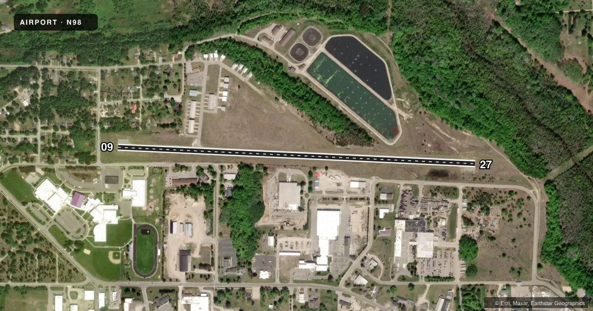
Airport sketch
Runways drawn to scale from FAA survey coordinates, rendered over satellite imagery. Not for navigation.
Approaches & charts
Services on the field
Fuel grades, oxygen, maintenance, ramp storage and lighting — as declared to the FAA by the airport operator.
Fuel & services
- Fuel
- 100LL
- Oxygen (bottled)
- Not available
- Oxygen (bulk)
- Not available
- Other services
- INSTR
Ramp & ground
- Transient storage
- Tie-down
- Landing fee
- No fee published
- Customs
- Not available
- Lighting schedule
- SEE RMK
- Wind indicator
- Lighted
- Segmented circle
- Yes
Fuel & FBOs
Cheapest 100LL and Jet A on the field and nearby. Always confirm with the FBO before taxi.
Airport notes
Surface conditions, obstructions, local procedures, lighting outages and other notes published with each FAA cycle.
General notes
- RWY 27 +250 FT HILL, 2 NM EAST, 16:1; +20 FT TREES, 480 FT DIST, 145 FT R, 14:1.
- DEER & BIRDS ON & INVOF ARPT.
- ADMIN BLDG ACES: PRESS 5, THEN 3 & 2 SIMUL, THEN 1.
- FOR CD CTC MINNEAPOLIS ARTCC AT 651-463-5588.
- FIRING RANGE NE OF FLD OPRS AT UNSKED TIMES, FOR ADZY CTC BOYNE CITY POLICE DEPT AT 231-582-6611.
- OVNGT PRKG FEE.
Lighting notes
- ACTVT REIL RWY 27; PAPI RWY 09; MIRL RWY 09/27 - 122.9.
Fuel notes
- 100LLSELF SVC.
Approach & departure obstructions
- 09+6 FT FENCE, 175 FT DIST; 19 FT ROAD, 197 FT DIST.
- 275 FT TREE, 190 FT DIST, 115 & 125 FT R.
- 0966 FT TREES, 624 FT DIST FM DTHR, 125-186 FT L, APCH RATIO 9:1 TO DTHR.
- 27CTLG OBSTN EXCEEDS A 45 DEG SLP.
Other notes
- ESTABD BFR 1959.
- ROPES NOT PRVDD.
VFR map & nearby airports
VFR sectional. Tap any ICAO chip to open that airport.
Key facts · N98
Answer card- ICAO
- N98
- Name
- BOYNE CITY MUNI
- Location
- BOYNE CITY, MICHIGAN
- Elevation
- 659.6 ft MSL
- Traffic pattern altitude
- 1,659.6 ft MSL (1,000 AGL)
- Control tower
- Non-towered (use CTAF)
- Total runways
- 1
- Longest runway
- 09/27 · 4,001 ft
- Published ILS approaches
- 0
- Published frequencies
- 2
- Magnetic variation
- 5°
- Current flight rules
- VFR
- Current wind
- 000° at 0 kt
- Favored runway now
- –
Boyne City Muni (N98) sits in Boyne City, Michigan. The field elevation is 659.6 ft MSL. It has one runway, 09/27, which is 4,001 ft long and asphalt. There is no control tower. The pattern altitude is not published, so use the standard 1,000 ft AGL for light piston operations unless current local guidance says otherwise.
No ILS approaches are published here. CTAF and UNICOM are both 122.8. The published remarks matter here. A firing range northeast of the field operates at unscheduled times. Deer and birds are also reported on and near the airport. Runway 09 has PAPI. Runway 27 has REIL lighting. Both runway ends have medium intensity runway lighting.
The on-field FBO is Boyne City Municipal Airport. It carries self-serve AVGAS 100LL. For a first-time arrival, pay close attention to the published obstructions near runway 09 and the hill east of runway 27. The field also has a cataloged obstruction on runway 27 that exceeds a 45 degree slope. If you need clearance delivery, contact Minneapolis ARTCC. If you want advisory on the firing range, call Boyne City Police Department before you go.