METAR & TAF KBFA
Current METAR
Observed 17:15Z
KBFA 271715Z AUTO 20005KT 10SM CLR 26/23 A2970 RMK AO2
- Wind
- 200° @ 5 kt
- Visibility
- 10 SM
- Temp / Dew
- 26°C / 23°C
- Altimeter
- 29.70 inHg
- Clouds
- CLR
- Density alt
- 2,484 ft
- Ceiling
- Unlimited
- Rules
- VFR
Airport info & contacts
Manager on record, flight service, ARTCC, attendance schedule and pattern altitude — published by the FAA and refreshed every 28 days.
Location
- From city
- 1 NM W
- VFR sectional
- LAKE HURON
- ARTCC
- ZMP · MINNEAPOLIS
- NOTAM facility
- BFA (NOTAM-D)
Airport manager
- Name
- CHRIS ADAMS
- Phone
- 231-549-6852
- Address
- BOYNE MOUNTAIN RESORT, PO BOX 19, BOYNE FALLS MI 49713-0019
Flight service · Hours
- FSS LAN
- LANSING1-800-WX-BRIEF
- Attendance
- Unattended
Frequencies
Tap any row to copy the frequency to your clipboard.
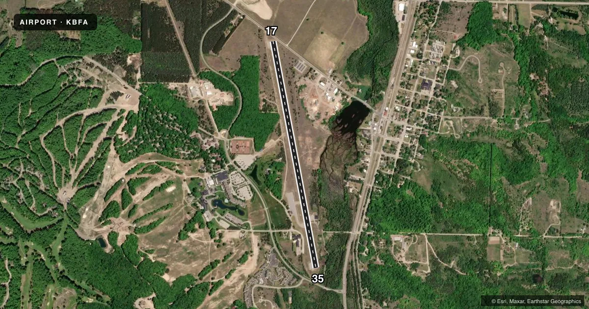
Runways & pattern
Full pagePattern entry · RWY 17
LEFT TRAFFICRunway end performance
| End | TORA | TODA | ASDA | LDA | VGSI | Approach lights | Obstruction |
|---|---|---|---|---|---|---|---|
| 17 | — | — | — | — | — | — | 15', road, 200' from thr, 55' R of cntrln, slope 0 |
| 35 | — | — | — | — | PAPI 2-box left(3°) | — | 22', trees, 200' from thr, 44' R of cntrln, slope 0 |
Declared distances in feet. TORA = takeoff run available, TODA = takeoff distance, ASDA = accelerate-stop, LDA = landing distance.
Airport sketch
Runways drawn to scale from FAA survey coordinates, rendered over satellite imagery. Not for navigation.
Approaches & charts
Services on the field
Fuel grades, oxygen, maintenance, ramp storage and lighting — as declared to the FAA by the airport operator.
Fuel & services
- Fuel
- 100LL
Ramp & ground
- Transient storage
- Tie-down
- Landing fee
- Yes
- Lighting schedule
- SEE RMK
- Wind indicator
- Lighted
- Segmented circle
- Yes
Fuel & FBOs
Cheapest 100LL and Jet A on the field and nearby. Always confirm with the FBO before taxi.
Airport notes
Surface conditions, obstructions, local procedures, lighting outages and other notes published with each FAA cycle.
General notes
- DEER, BIRDS, & WILDLIFE ON & INVOF ARPT.
- FOR CD CTC MINNEAPOLIS ARTCC AT 651-463-5588.
- RWY 17/35 TREES, BLDGS, & ROADS IN PRI SFC.
- PEDESTRIANS INVOF RWY ENVIRONMENT - LODGING 200 FT WEST OF RWY 35 DESIGNATOR.
Lighting notes
- ACTVT REIL RWY 17 & 35; PAPI RWY 35; MIRL RWY 17/35 - CTAF.
Fuel notes
- 100LLAVBL H24 SELF SVC VIA CREDIT CARD.
Approach & departure obstructions
- 17+15 FT ROAD, 0-199 FT DIST, 100 FT L TO 90 FT R.
- 35+25 FT TREES, 200-500 FT DIST, 165 FT R.
- 17APCH RATIO 20:1 TO DTHR OVR 15 FT ROAD, 300 FT DIST, 100 FT L.
- 35APCH RATIO 11:1 TO DTHR OVR 44 FT TREES, 510 FT DIST, 166 FT R.
Other notes
- ESTABD BFR 1959.
- FOR LDG FEES CTC AMGR FOR DTLS.
- ROPES NOT PRVDD.
VFR map & nearby airports
VFR sectional. Tap any ICAO chip to open that airport.
Key facts · KBFA
Answer card- ICAO
- KBFA
- Name
- BOYNE MOUNTAIN
- Location
- BOYNE FALLS, MICHIGAN
- Elevation
- 719 ft MSL
- Traffic pattern altitude
- 1,719 ft MSL (1,000 AGL)
- Control tower
- Non-towered (use CTAF)
- Total runways
- 1
- Longest runway
- 17/35 · 5,187 ft
- Published ILS approaches
- 0
- Published frequencies
- 2
- Magnetic variation
- 6°
- Current flight rules
- VFR
- Current wind
- 200° at 5 kt
- Favored runway now
- RWY 17
Boyne Mountain Airport is in Boyne Falls, Michigan. The field elevation is 719 ft MSL. It has one runway, 17/35, which is 5,187 ft long. There is no control tower. CTAF and UNICOM are both 122.8. No ILS approaches are published here.
Pattern altitude is not published. Use the standard 1,000 ft AGL pattern unless the current Chart Supplement or local procedures say otherwise. Boyne Mountain Resort is the on-field FBO. It carries 100LL. Self-serve 100LL is available 24 hours a day by credit card. The airport also notes that ropes are not provided.
This is a non-towered field with wildlife reported on and near the airport. The runway environment also has several published obstructions. Runway 17 has a displaced threshold with roads near the approach path. Runway 35 has trees near the approach end. The runway lights are medium intensity and are controlled on CTAF. REILs are installed on both ends. PAPI is available on runway 35. If you are new to the field, review the current Chart Supplement before arrival. That is the best place to confirm any local procedures, landing fee details and current operational notes.