METAR & TAF KACB
Current METAR
Observed 16:35Z
KACB 271635Z AUTO 00000KT 10SM SCT014 SCT120 25/20 A2975 RMK AO2 T02500199
- Wind
- 000° @ 0 kt
- Visibility
- 10 SM
- Temp / Dew
- 25°C / 20°C
- Altimeter
- 29.75 inHg
- Clouds
- SCT
- Density alt
- 2,183 ft
- Ceiling
- Unlimited
- Rules
- VFR
Airport info & contacts
Manager on record, flight service, ARTCC, attendance schedule and pattern altitude — published by the FAA and refreshed every 28 days.
Location
- From city
- 1 NM NE
- VFR sectional
- GREEN BAY
- ARTCC
- ZMP · MINNEAPOLIS
- NOTAM facility
- ACB (NOTAM-D)
Airport manager
- Name
- MATTHEW WYMAN
- Phone
- 231-533-8524
- Address
- 3366A S DERENZY RD, BELLAIRE MI 49615-9499
Flight service · Hours
- FSS LAN
- LANSING1-800-WX-BRIEF
- Attendance
- 0700-1700
Frequencies
Tap any row to copy the frequency to your clipboard.
Runways & pattern
Full pagePattern entry · RWY 02
LEFT TRAFFICRunway end performance
| End | TORA | TODA | ASDA | LDA | VGSI | Approach lights | Obstruction |
|---|---|---|---|---|---|---|---|
| 02 | — | — | — | — | PAPI 4-box left(3°) | — | 62', tree, 1667' from thr, 112' R of cntrln, slope 23 |
| 20 | — | — | — | — | PAPI 2-box left(3.25°) | — | — |
Declared distances in feet. TORA = takeoff run available, TODA = takeoff distance, ASDA = accelerate-stop, LDA = landing distance.
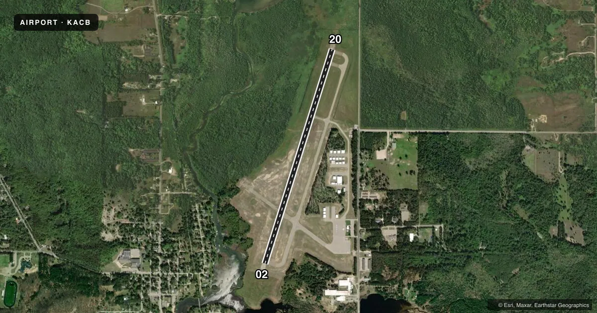
Airport sketch
Runways drawn to scale from FAA survey coordinates, rendered over satellite imagery. Not for navigation.
Approaches & charts
Services on the field
Fuel grades, oxygen, maintenance, ramp storage and lighting — as declared to the FAA by the airport operator.
Fuel & services
- Fuel
- 100LLA+
Ramp & ground
- Transient storage
- Tie-down
- Hangar
- Landing fee
- Yes
- Customs
- Not available
- Lighting schedule
- SEE RMK
- Beacon schedule
- SS-SR
- Beacon
- White / Green (civil land)(WG)
- Wind indicator
- Lighted
- Segmented circle
- Yes
Fuel & FBOs
Cheapest 100LL and Jet A on the field and nearby. Always confirm with the FBO before taxi.
Airport notes
Surface conditions, obstructions, local procedures, lighting outages and other notes published with each FAA cycle.
General notes
- LRG BIRDS ON & INVOF ARPT.
- SNOW REMOVAL EQPT ON RWY & TWYS DURG WINTER MONTHS.
- FOR CD CTC MINNEAPOLIS ARTCC AT 651-463-5588.
Lighting notes
- ACTVT OR INCR INTST REIL RWY 02 & 20; PAPI RWY 02 & 20; MIRL RWY 02/20 - CTAF. MIRL RWY 02/20 PRESET LOW INTST.
Fuel notes
- 100LLFOR FUEL AFT HRS CALL 231-350-8145.
Other notes
- LDG FEE APPLIES TO TURBINE & JET ENG ACFT; WAIVED WITH MNM FUEL PURCHASE.
- LGTD SUPPLL WIND CONES EACH END RWY 02 & 20.
- 1UNATNDD MAJOR HOLS.
- MANAGERCELL 231-622-1926.
VFR map & nearby airports
VFR sectional. Tap any ICAO chip to open that airport.
Key facts · KACB
Answer card- ICAO
- KACB
- Name
- ANTRIM COUNTY
- Location
- BELLAIRE, MICHIGAN
- Elevation
- 623 ft MSL
- Traffic pattern altitude
- 1,623 ft MSL (1,000 AGL)
- Control tower
- Non-towered (use CTAF)
- Total runways
- 1
- Longest runway
- 02/20 · 5,003 ft
- Published ILS approaches
- 0
- Published frequencies
- 2
- Magnetic variation
- 5°
- Current flight rules
- VFR
- Current wind
- 000° at 0 kt
- Favored runway now
- –
Antrim County Airport sits near Bellaire, Michigan. The field elevation is 623 ft MSL. It has one runway. Runway 02/20 is 5,003 ft long with an asphalt surface. There is no control tower. CTAF and UNICOM are both 122.7. No ILS approaches are published here.
The traffic pattern altitude is not published. Use the standard 1,000 ft AGL for light piston traffic unless the current Chart Supplement says otherwise. The airport is unattended on major holidays. Large birds are reported on and near the field. Snow removal equipment can be on the runway and taxiways during winter months. Expect active ground ops in colder weather.
Antrim County Airport is the on-field FBO. It carries 100LL and Jet A. For after-hours fuel, the published remarks give a phone number to call. Runway end identifier lights, PAPI for both ends and the medium intensity runway lights are activated on CTAF. The runway lights are preset to low intensity. If you are coming in with a turbine or jet, check the current fee rules before arrival. For clearance delivery, contact Minneapolis ARTCC. First-time pilots should also plan for the lighting setup. Keep an eye out for birds and winter equipment.