METAR & TAF Y94
Y94 does not publish a METAR.
Showing the nearest reporting station: KBFA (BOYNE MOUNTAIN) · 8.0 NM away. Conditions at Y94 may differ.
METAR · KBFA
Observed 19:35Z
KBFA 271935Z AUTO 28005KT 10SM CLR 30/23 A2968 RMK AO2
- Wind
- 280° @ 5 kt
- Visibility
- 10 SM
- Temp / Dew
- 30°C / 23°C
- Altimeter
- 29.68 inHg
- Clouds
- CLR
- Density alt
- 2,892 ft
- Ceiling
- Unlimited
- Rules
- VFR
Airport info & contacts
Manager on record, flight service, ARTCC, attendance schedule and pattern altitude — published by the FAA and refreshed every 28 days.
Location
- From city
- 2 NM SE
- VFR sectional
- GREEN BAY
- ARTCC
- ZMP · MINNEAPOLIS
- NOTAM facility
- LAN (NOTAM-D)
Airport manager
- Name
- TOM CANNON, CITY MGR
- Phone
- 231-536-3381
- Address
- 201 MAIN ST, EAST JORDAN MI 49727
Flight service · Hours
- FSS LAN
- LANSING1-800-WX-BRIEF
- Attendance
- Unattended
Frequencies
Tap any row to copy the frequency to your clipboard.
Runways & pattern
Full pagePattern entry · RWY 27
LEFT TRAFFIC| Runway | Heading (°M) | Length | Surface | Traffic |
|---|---|---|---|---|
| 09/27Favored | 86° / 266° | 3,250 ft | ASPH | Standard L |
| 18/36 | 175° / 355° | 1,800 ft | TURF | Standard L |
Runway end performance
| End | TORA | TODA | ASDA | LDA | VGSI | Approach lights | Obstruction |
|---|---|---|---|---|---|---|---|
| 27 | — | — | — | — | VASI 2-box left(4°) | — | 15', road, 232' from thr, 0' R of cntrln, slope 2 |
| 18 | — | — | — | — | — | — | 55', trees, 545' from thr, 198' R of cntrln, slope 9 |
| 36 | — | — | — | — | — | — | 37', trees, 0' from thr, 125' R of cntrln, slope 1 |
Declared distances in feet. TORA = takeoff run available, TODA = takeoff distance, ASDA = accelerate-stop, LDA = landing distance.
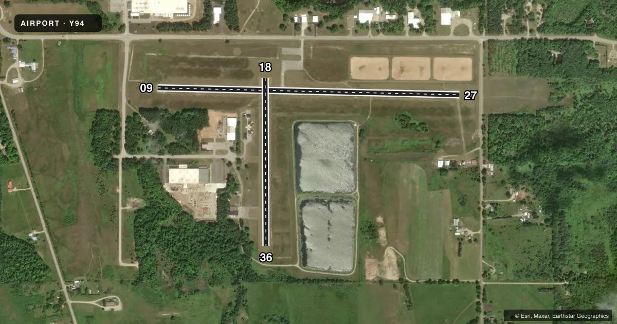
Airport sketch
Runways drawn to scale from FAA survey coordinates, rendered over satellite imagery. Not for navigation.
Approaches & charts
Services on the field
Fuel grades, oxygen, maintenance, ramp storage and lighting — as declared to the FAA by the airport operator.
Fuel & services
- Fuel
- Not available
- Airframe repair
- Not available
Ramp & ground
- Transient storage
- Tie-down
- Landing fee
- No fee published
- Customs
- Not available
- Lighting schedule
- SEE RMK
- Wind indicator
- Lighted
- Segmented circle
- Yes
Fuel & FBOs
Cheapest 100LL and Jet A on the field and nearby. Always confirm with the FBO before taxi.
Airport notes
Surface conditions, obstructions, local procedures, lighting outages and other notes published with each FAA cycle.
General notes
- DEER, BIRDS, & WILDLIFE ON & INVOF ARPT.
- 1670 FT MSL TWR 3 MI NE.
- FOR CD CTC MINNEAPOLIS ARTCC AT 651-463-5588.
Lighting notes
- ACTVT MIRL RWY 09/27 - CTAF. VASI RWY 27 OTS INDEFLY.
Runway surface & condition
- 18/36CLSD NOV-APR & WHEN SNOW COVD EXC FOR SKI EQUIPPED ACFT. NO SNOW REMOVAL.
Approach & departure obstructions
- 183 FT YELLOW CONES.
- 363 FT YELLOW CONES.
- 18APCH RATIO 16:1 BASED ON STRAIGHT OUT OVR 62 FT TREE, 1036 FT DIST, 0 FT B.
- 27APCH RATIO 18:1 TO DTHR OVR +80 FT TREES, 1470 FT DIST, 165 FT R.
Other notes
- ESTABD BFR 1959.
- TIEDOWNS NOT PRVDD.
- MANAGERCELL 231-357-0646.
VFR map & nearby airports
VFR sectional. Tap any ICAO chip to open that airport.
Key facts · Y94
Answer card- ICAO
- Y94
- Name
- EAST JORDAN CITY
- Location
- EAST JORDAN, MICHIGAN
- Elevation
- 641 ft MSL
- Traffic pattern altitude
- 1,641 ft MSL (1,000 AGL)
- Control tower
- Non-towered (use CTAF)
- Total runways
- 2
- Longest runway
- 09/27 · 3,250 ft
- Published ILS approaches
- 0
- Published frequencies
- 1
- Magnetic variation
- 5°
- Current flight rules
- VFR
- Current wind
- 280° at 5 kt
- Favored runway now
- RWY 27
East Jordan City Airport sits in East Jordan, Michigan. The field elevation is 641 ft MSL. It has two runways. The longest is 09/27 at 3,250 ft asphalt. Runway 18/36 is 1,800 ft turf. This is an unattended field with no control tower. CTAF is 122.9. No ILS approaches are published here.
Pattern altitude is not published. Use 1,000 ft AGL for light piston operations unless local guidance says otherwise. That puts the traffic pattern at about 1,641 ft MSL based on field elevation. Runway 09/27 has medium intensity lights that are activated by CTAF. The VASI for runway 27 is out of service indefinitely. Runway 18/36 is closed from November through April and whenever snow covered, except for ski equipped aircraft. No snow removal is provided.
There are no on-field FBOs listed. Tiedowns are not provided. Expect wildlife on and near the airport. The published remarks also call out trees on the approach to runway 18 and trees near the displaced threshold for runway 27. The airport is in a non-towered environment, so standard self-announce traffic discipline matters. If you need current operational details, check the current FAA Chart Supplement or call the airport operator directly. For clearance delivery, Minneapolis ARTCC is listed in the remarks.