METAR & TAF KGLR
Current METAR
Observed 14:53Z
KGLR 271453Z AUTO 25009KT 10SM FEW014 26/21 A2973 RMK AO2 SLP061 T02560211 58007
- Wind
- 250° @ 9 kt
- Visibility
- 10 SM
- Temp / Dew
- 26°C / 21°C
- Altimeter
- 29.73 inHg
- Clouds
- FEW
- Density alt
- 3,202 ft
- Ceiling
- Unlimited
- Rules
- VFR
Airport info & contacts
Manager on record, flight service, ARTCC, attendance schedule and pattern altitude — published by the FAA and refreshed every 28 days.
Location
- From city
- 1 NM SW
- VFR sectional
- LAKE HURON
- ARTCC
- ZMP · MINNEAPOLIS
- NOTAM facility
- GLR (NOTAM-D)
Airport manager
- Name
- SHARI RIVEST
- Phone
- 989-732-4218
- Address
- PO BOX 1396, GAYLORD MI 49734-5396
Flight service · Hours
- FSS LAN
- LANSING1-800-WX-BRIEF
- Attendance
- MAY-OCT · 0730-1800
- NOV-APR · 0630-1700
Frequencies
Tap any row to copy the frequency to your clipboard.
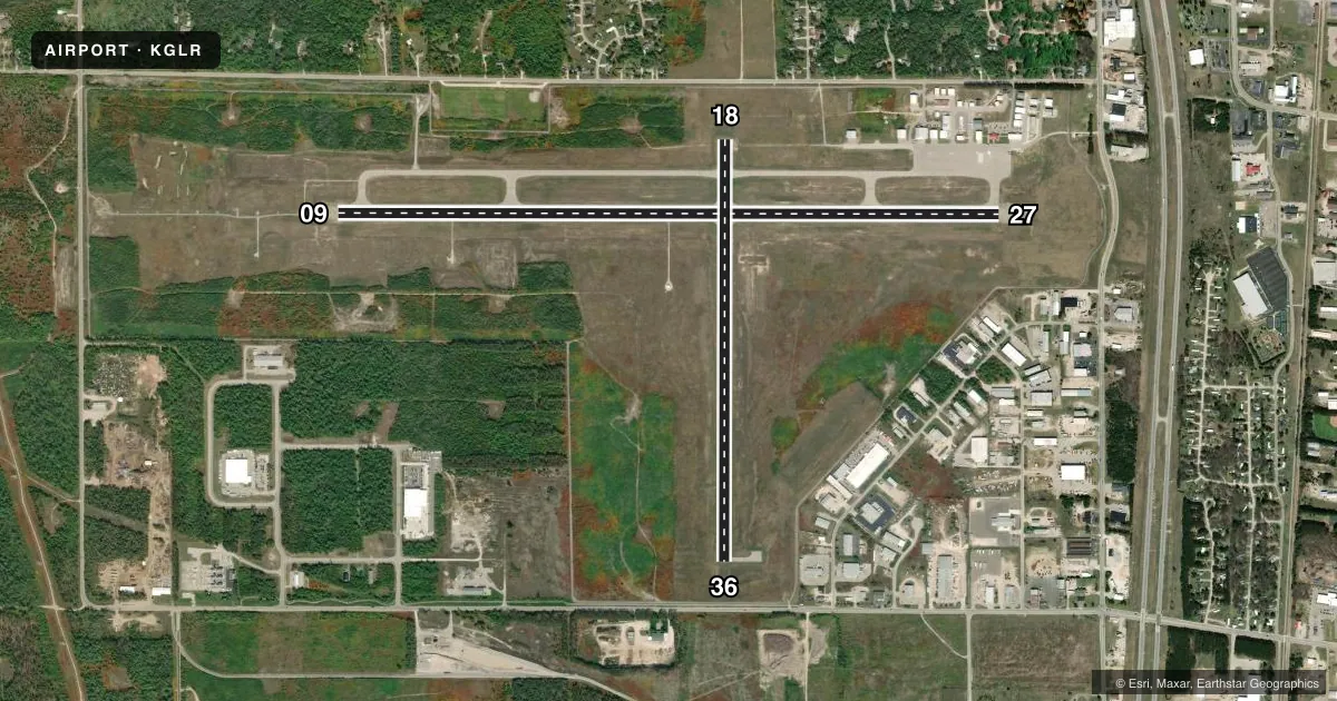
Runways & pattern
Full pagePattern entry · RWY 27
LEFT TRAFFIC| Runway | Heading (°M) | Length | Surface | Traffic |
|---|---|---|---|---|
| 09/27Favored | 84° / 264° | 6,579 ft | ASPH | Standard L |
| 18/36 | 174° / 354° | 4,200 ft | ASPH | Standard L |
Runway end performance
| End | TORA | TODA | ASDA | LDA | VGSI | Approach lights | Obstruction |
|---|---|---|---|---|---|---|---|
| 09 | — | — | — | — | PAPI 4-box left(3°) | MALSR | 58', tree, 2040' from thr, 213' R of cntrln, slope 31 |
| 27 | — | — | — | — | PAPI 4-box left(3°) | — | 38', pole, 1117' from thr, 278' R of cntrln, slope 24 |
| 18 | — | — | — | — | PAPI 4-box left(3°) | — | — |
| 36 | — | — | — | — | PAPI 4-box left(3°) | — | — |
Declared distances in feet. TORA = takeoff run available, TODA = takeoff distance, ASDA = accelerate-stop, LDA = landing distance.
Airport sketch
Runways drawn to scale from FAA survey coordinates, rendered over satellite imagery. Not for navigation.
Approaches & charts
ILS · 1
Services on the field
Fuel grades, oxygen, maintenance, ramp storage and lighting — as declared to the FAA by the airport operator.
Fuel & services
- Fuel
- 100LLA+
- Oxygen (bottled)
- HIGH/LOW
- Airframe repair
- Major
- Power plant repair
- Major
- Other services
- AMB,CARGO,CHTR
Ramp & ground
- Transient storage
- Tie-down
- Hangar
- Landing fee
- No fee published
- Customs
- Not available
- Lighting schedule
- SEE RMK
- Beacon schedule
- SS-SR
- Beacon
- White / Green (civil land)(WG)
- Wind indicator
- Lighted
- Segmented circle
- Yes
Fuel & FBOs
Cheapest 100LL and Jet A on the field and nearby. Always confirm with the FBO before taxi.
Airport notes
Surface conditions, obstructions, local procedures, lighting outages and other notes published with each FAA cycle.
General notes
- DEER & BIRDS ON & INVOF ARPT.
- MIL TRG ACT INVOF ARPT ASSOCD WITH R-4201A/B.
- ADMIN BLDG ACES 5-3-2-1.
- FOR CD IF UNA TO CTC ON FSS FREQ, CTC MINNEAPOLIS ARTCC AT 651-463-5588.
Lighting notes
- ACTVT MALSR RWY 09; REIL RWY 27, 18, & 36; PAPI RWY 09, 27, 18, & 36; HIRL RWY 09/27; MIRL RWY 18/36 - CTAF.
Fuel notes
- 100LLSUBJ AFT HRS CALL-IN FEE.
Approach & departure obstructions
- 36PAPI UNUSBL BYD 8 DEGS LEFT & 7 DEGS RIGHT OF CNTRLN.
Other notes
- LDG FEE FOR TURBINE, JET, & TWIN-ENG ACFT WAIVED WITH MNM FUEL PURCHASE. OVNGT PRKG FEE.
- OVNGT PRKG FEE.
- 3FOR ATTENDANT AFT HRS CALL AMGR. UNATNDD THANKSGIVING, CHRISTMAS, & NEW YEARS DAY.
- MANAGERCELL 989-390-5980.
VFR map & nearby airports
VFR sectional. Tap any ICAO chip to open that airport.
Key facts · KGLR
Answer card- ICAO
- KGLR
- Name
- GAYLORD RGNL
- Location
- GAYLORD, MICHIGAN
- Elevation
- 1,328.1 ft MSL
- Traffic pattern altitude
- 2,328.1 ft MSL (1,000 AGL)
- Control tower
- Non-towered (use CTAF)
- Total runways
- 2
- Longest runway
- 09/27 · 6,579 ft
- Published ILS approaches
- 1
- Published frequencies
- 2
- Magnetic variation
- 6°
- Current flight rules
- VFR
- Current wind
- 250° at 9 kt
- Favored runway now
- RWY 27
Gaylord Regional Airport sits in Gaylord, Michigan. The field elevation is 1,328.1 ft MSL. It has two asphalt runways. The longest is runway 09/27 at 6,579 ft. Runway 18/36 is 4,200 ft. The airport is not towered. CTAF and UNICOM are both 122.8. The published pattern altitude is not listed. Use the standard 1,000 ft AGL pattern unless local procedures say otherwise. That puts the light piston pattern at about 2,328 ft MSL.
An ILS is published for runway 09. The lighting setup is useful after dark. MALSR is on runway 09. REIL is available on 27, 18 and 36. PAPI is available on all four runway ends. High intensity lighting serves 09 and 27. Medium intensity lighting serves 18 and 36. The on-field FBO is Gaylord Regional Airport. It carries 100LL and Jet A Prist. Call the field at (989) 732-4218 for current service details.
Plan for wildlife on the field. Deer and birds are reported on and near the airport. Military training activity also occurs nearby in restricted areas R-4201A and R-4201B. For clearance delivery, if Flight Service is not available, contact Minneapolis ARTCC at 651-463-5588. The airport manager can also be reached at 989-390-5980. Check current procedures before arrival if you are operating at night or in low visibility.