METAR & TAF KGOV
Current METAR
Observed 15:55Z
KGOV 241555Z AUTO 22008KT 10SM FEW043 23/13 A3016 RMK AO2 SLP218 T02330129 $
- Wind
- 220° @ 8 kt
- Visibility
- 10 SM
- Temp / Dew
- 23°C / 13°C
- Altimeter
- 30.16 inHg
- Clouds
- FEW
- Density alt
- 2,098 ft
- Ceiling
- Unlimited
- Rules
- VFR
Airport info & contacts
Manager on record, flight service, ARTCC, attendance schedule and pattern altitude — published by the FAA and refreshed every 28 days.
Location
- From city
- 1 NM NW
- VFR sectional
- LAKE HURON
- ARTCC
- ZMP · MINNEAPOLIS
- NOTAM facility
- GOV (NOTAM-D)
Airport manager
- Name
- SCOTT KARNER
- Phone
- 989-344-4301
- Address
- JMTC GAAF BLDG 1160, CAMP GRAYLING, GRAYLING MI 49738
Flight service · Hours
- FSS LAN
- LANSING1-800-WX-BRIEF
- Attendance
- TUE-FRI · 1200-2200Z
Frequencies
Tap any row to copy the frequency to your clipboard.
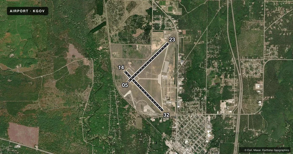
Runways & pattern
Full pagePattern entry · RWY 23
RIGHT TRAFFIC| Runway | Heading (°M) | Length | Surface | Traffic |
|---|---|---|---|---|
| 14/32 | 130° / 310° | 5,005 ft | ASPH | 14 R |
| 05/23Favored | 40° / 220° | 5,000 ft | CONC | 23 R |
Runway end performance
| End | TORA | TODA | ASDA | LDA | VGSI | Approach lights | Obstruction |
|---|---|---|---|---|---|---|---|
| 14 | — | — | — | — | PAPI 4-box left(3°) | — | 60', tree, 1438' from thr, 435' R of cntrln, slope 20 |
| 32 | — | — | — | — | PAPI 4-box left(3.5°) | — | 61', trees, 939' from thr, 200' R of cntrln, slope 12 |
| 05 | — | — | — | — | PAPI 4-box left(4°) | — | 75', trees, 1362' from thr, 25' R of cntrln, slope 15 |
| 23 | — | — | — | — | PAPI 4-box left(3°) | — | 58', trees, 1277' from thr, 125' R of cntrln, slope 18 |
Declared distances in feet. TORA = takeoff run available, TODA = takeoff distance, ASDA = accelerate-stop, LDA = landing distance.
Airport sketch
Runways drawn to scale from FAA survey coordinates, rendered over satellite imagery. Not for navigation.
Approaches & charts
Services on the field
Fuel grades, oxygen, maintenance, ramp storage and lighting — as declared to the FAA by the airport operator.
Fuel & services
- Fuel
- 100LLA+
- Oxygen (bottled)
- Not available
- Oxygen (bulk)
- Not available
Ramp & ground
- Transient storage
- Tie-down
- Landing fee
- No fee published
- Customs
- Not available
- Lighting schedule
- SEE RMK
- Beacon schedule
- SS-SR
- Beacon
- Split White / Green (military)(SWG)
- Wind indicator
- Lighted
- Segmented circle
- Yes
Fuel & FBOs
Cheapest 100LL and Jet A on the field and nearby. Always confirm with the FBO before taxi.
Airport notes
Surface conditions, obstructions, local procedures, lighting outages and other notes published with each FAA cycle.
General notes
- BIRD & WILDLIFE HAZ. NATIVE RAVENS & CROWS IN & ARND AFLD YEAR-ROUND.
- EXTSV MIL HEL TFC JUN THRU AUG.
- PARTS OF THE AIRFIELD CLSD DRG WINTER MONTHS - CK NOTAMS.
- CIV TRML BLDG ACES: 5-4-3-2-1.
- FOR FICON C989-344-4301, UNMON OUTSIDE OPRG HRS.
- MILITARY: SVC: UNAVBL EXC 24 HR PPR 989-344-4301, ACFT MUST MEET PPR TIME WI 30 MINS.
- MILITARY: ALL HAZUS CARGO MUST BE APVD BY AIRFIELD MGR.
- ALL AFLD SIGNS UNLGTD. ALL TWYS UNLGTD.
- EXP CLOSURE OR RDCD SVC PER NOTAM.
- PAVEMENT EVAL NOT CURRENT. ALL AMC ACFT CTC MGMT FOR WAIVERS & RSTRNS.
- NO RWY SHOULDERS. NO RWY OVRNS. NO TWY SHOULDERS. ALL TWY SFC MRKGS NSTD & FADED. ALL MIL RAMP SFCS NSTD & FADED. GA RAMP SFC MRKGS NSTD & FADED. GA FUEL FARM RAMP SFC MRKGS NSTD & FADED.
Lighting notes
- ACTVT REIL RWY 14, 32, 05, & 23; PAPI RWY 14, 32, 05, & 23; MIRL RWY 14/32 & 05/23 - CTAF.
Fuel notes
- 100LL100LL & JET A+ AVBL H24 SELF SVC VIA CREDIT CARD. FOR FUEL SUPPORT CTC BASOPS AT 989-344-4301, 24 HR PN FOR FUEL SUPPORT OUTSIDE OPRG HRS.
Runway surface & condition
- 05/23PCN 18 DRG FROST CONDS.
- 14/32PCN 59 DRG FROST CONDS.
Approach & departure obstructions
- 05OPEN TO VFR LDGS SR-SS.
- 32APCH RATIO 20:1 TO DTHR OVR 68 FT TREES, 1423 FT DIST, 125 FT R.
- 32+26 FT PLINE, 488 FT DIST, 11:1; +15 FT ROAD, 250 FT DIST, 250 FT L, 3:1.
Other notes
- ARFF CAPABILITIES LTD OCT-MAY.
- ROTOR WING 1700 FT MSL; FIXED WING 2200 FT MSL; OVHD 2700 FT MSL.
- FOR HNGR STORAGE CALL 989-344-3202.
- 3EXC FEDERAL HOLS OR BY NOTAM.
- MANAGERC989-344-4301 (FLT OPS) OR C517-897-8266 (FLT OPS SUPVR CELL); C989-344-4310 (AMGR CELL).
- 05/23IREG SFC; FOD LCTD THRUT RWY.
VFR map & nearby airports
VFR sectional. Tap any ICAO chip to open that airport.
Key facts · KGOV
Answer card- ICAO
- KGOV
- Name
- GRAYLING AAF
- Location
- GRAYLING, MICHIGAN
- Elevation
- 1,158.1 ft MSL
- Traffic pattern altitude
- 2,158.1 ft MSL (1,000 AGL)
- Control tower
- Towered · OPR 1200-2200Z TUE-FRI OR BY NOTAM
- Total runways
- 2
- Longest runway
- 14/32 · 5,005 ft
- Published ILS approaches
- 0
- Published frequencies
- 7
- Magnetic variation
- 6°
- Current flight rules
- VFR
- Current wind
- 220° at 8 kt
- Favored runway now
- RWY 23
Grayling AAF sits in Grayling, Michigan. Field elevation is 1,158.1 ft MSL. The airport has two runways. The longest is 5,005 ft on runway 14/32. Runway 05/23 is 5,000 ft. The field is towered. Tower hours are 1300-0500Z Monday through Friday from 1 Apr to 30 Sep. Hours are 1300-0100Z Monday through Friday from 1 Oct to 31 Mar. No ILS approaches are published here.
The published traffic pattern altitude is 1,700 ft MSL for rotor wing aircraft. Fixed wing pattern altitude is 2,200 ft MSL. Overhead is at 2,700 ft MSL. Crawford County Air Terminal is on the field. It carries AVGAS 100LL and Jet A. 100LL and Jet A+ are also available 24 hours a day self-service by credit card. Call base operations at 989-344-4301 for fuel support outside operating hours.
A few remarks matter for planning. Parts of the airfield close during winter months, so check NOTAMs before departure. Runway 05/23 has an irregular surface with foreign object debris throughout the runway. Runway 14/32 has a displaced threshold issue near 68-foot trees off the approach end. The field elevation is high enough that performance planning still matters on warm days. Military service needs prior permission. Call the flight information center at 989-344-4301 before you go.