METAR & TAF D90
D90 does not publish a METAR.
Showing the nearest reporting station: KACB (ANTRIM COUNTY) · 6.8 NM away. Conditions at D90 may differ.
METAR · KACB
Observed 18:15Z
KACB 271815Z AUTO 19004KT 10SM CLR 26/20 A2969 RMK AO2 T02570201
- Wind
- 190° @ 4 kt
- Visibility
- 10 SM
- Temp / Dew
- 26°C / 20°C
- Altimeter
- 29.69 inHg
- Clouds
- CLR
- Density alt
- 3,010 ft
- Ceiling
- Unlimited
- Rules
- VFR
Airport info & contacts
Manager on record, flight service, ARTCC, attendance schedule and pattern altitude — published by the FAA and refreshed every 28 days.
Location
- From city
- 2 NM N
- VFR sectional
- GREEN BAY
- ARTCC
- ZMP · MINNEAPOLIS
- NOTAM facility
- LAN (NOTAM-D)
Airport manager
- Name
- SHAWN D FLEET
- Phone
- 231-645-3208
- Address
- 7507 CEDAR RIVER RD, MANCELONA MI 49659
Flight service · Hours
- FSS LAN
- LANSING1-800-WX-BRIEF
- Attendance
- Unattended
Frequencies
Tap any row to copy the frequency to your clipboard.
Runways & pattern
Full pagePattern entry · RWY 18
LEFT TRAFFIC| Runway | Heading (°M) | Length | Surface | Traffic |
|---|---|---|---|---|
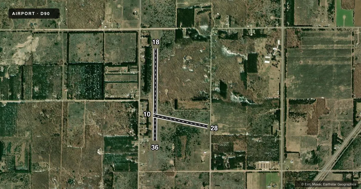
| 18/36Favored | 175° / 355° | 3,400 ft | TURF | Standard L |
| 10/28 | 97° / 277° | 2,050 ft | TURF | Standard L |
Runway end performance
| End | TORA | TODA | ASDA | LDA | VGSI | Approach lights | Obstruction |
|---|---|---|---|---|---|---|---|
| 18 | — | — | — | — | — | — | 62', tree, 996' from thr, 140' R of cntrln, slope 16 |
| 10 | — | — | — | — | — | — | 62', trees, 175' from thr, 98' R of cntrln, slope 2 |
| 28 | — | — | — | — | — | — | 16', road, 90' from thr, 134' R of cntrln, slope 5 |
Declared distances in feet. TORA = takeoff run available, TODA = takeoff distance, ASDA = accelerate-stop, LDA = landing distance.
Airport sketch
Runways drawn to scale from FAA survey coordinates, rendered over satellite imagery. Not for navigation.
Approaches & charts
Services on the field
Fuel grades, oxygen, maintenance, ramp storage and lighting — as declared to the FAA by the airport operator.
Fuel & services
- Fuel
- Not available
Ramp & ground
- Transient storage
- Tie-down
- Landing fee
- No fee published
- Customs
- Not available
- Wind indicator
- Yes
- Segmented circle
- Yes
Fuel & FBOs
Cheapest 100LL and Jet A on the field and nearby. Always confirm with the FBO before taxi.
Airport notes
Surface conditions, obstructions, local procedures, lighting outages and other notes published with each FAA cycle.
General notes
- ARPT CLSD NOV-APR 15 & WHEN SNOW COVD EXC FOR SKI EQUIPPED ACFT; RWYS NOT PLWD.
- FOR CD CTC MINNEAPOLIS ARTCC AT 651-463-5588.
Approach & departure obstructions
- 10RWY & DTHR MKD WITH 3 FT YELLOW CONES.
- 183 FT YELLOW CONES.
- 28RWY & DTHR MKD WITH 3 FT YELLOW CONES.
- 363 FT YELLOW CONES.
- 10APCH RATIO 0:1 TO DTHR OVR 20 FT TREES, 0 FT DIST, 125 FT R.
- 28APCH RATIO 7:1 TO DTHR OVR 62 FT TREE, 450 FT DIST, 125 FT L.
- 28ALSO 62 FT TREE, 250 FT DIST, 125 FT L, APCH RATIO 4:1.
Other notes
- ESTABD BFR 1959.
- PILOTS MUST SUP ROPES.
VFR map & nearby airports
VFR sectional. Tap any ICAO chip to open that airport.
Key facts · D90
Answer card- ICAO
- D90
- Name
- MANCELONA MUNI
- Location
- MANCELONA, MICHIGAN
- Elevation
- 1,133 ft MSL
- Traffic pattern altitude
- 2,133 ft MSL (1,000 AGL)
- Control tower
- Non-towered (use CTAF)
- Total runways
- 2
- Longest runway
- 18/36 · 3,400 ft
- Published ILS approaches
- 0
- Published frequencies
- 1
- Magnetic variation
- 5°
- Current flight rules
- VFR
- Current wind
- 190° at 4 kt
- Favored runway now
- RWY 18
Mancelona Muni sits in Mancelona, Michigan at 1,133 ft MSL. It has two turf runways. The longest is 18/36 at 3,400 ft. The other runway is 10/28 at 2,050 ft. There is no control tower. CTAF is 122.9. No ILS approaches are published. Pattern altitude is not published, so use the standard 1,000 ft AGL for light piston operations unless the current Chart Supplement says otherwise.
This is a small field with a few operational details that matter. The published remarks say the airport is closed from November through April 15. It is also closed when snow covered except for ski equipped aircraft. The runways are not plowed. Pilots must supply ropes. The remarks also note displaced thresholds and tree obstructions near the runway ends, so take a close look at the current Chart Supplement before you go.
There are no on-field FBOs listed in the facts, so call the airport operator or the field directly for current services before arrival. For clearance delivery, contact Minneapolis ARTCC at 651-463-5588. This is a turf strip with no tower and no published ILS, so plan for a simple VFR arrival and verify current field condition before departure.