METAR & TAF 59M
59M does not publish a METAR.
Showing the nearest reporting station: KACB (ANTRIM COUNTY) · 7.8 NM away. Conditions at 59M may differ.
METAR · KACB
Observed 18:55Z
KACB 271855Z AUTO 00000KT 10SM CLR 28/20 A2968 RMK AO2 T02770198
- Wind
- 000° @ 0 kt
- Visibility
- 10 SM
- Temp / Dew
- 28°C / 20°C
- Altimeter
- 29.68 inHg
- Clouds
- CLR
- Density alt
- 2,651 ft
- Ceiling
- Unlimited
- Rules
- VFR
Airport info & contacts
Manager on record, flight service, ARTCC, attendance schedule and pattern altitude — published by the FAA and refreshed every 28 days.
Location
- From city
- 3 NM S
- VFR sectional
- GREEN BAY
- ARTCC
- ZMP · MINNEAPOLIS
- NOTAM facility
- LAN (NOTAM-D)
Airport manager
- Name
- TIMOTHY BAISE
- Phone
- 517-420-3684
- Address
- 118 W GRAND RIVER AVE, WILLIAMSTON MI 48895-1318
Flight service · Hours
- FSS LAN
- LANSING1-800-WX-BRIEF
- Attendance
- Unattended
Frequencies
Tap any row to copy the frequency to your clipboard.
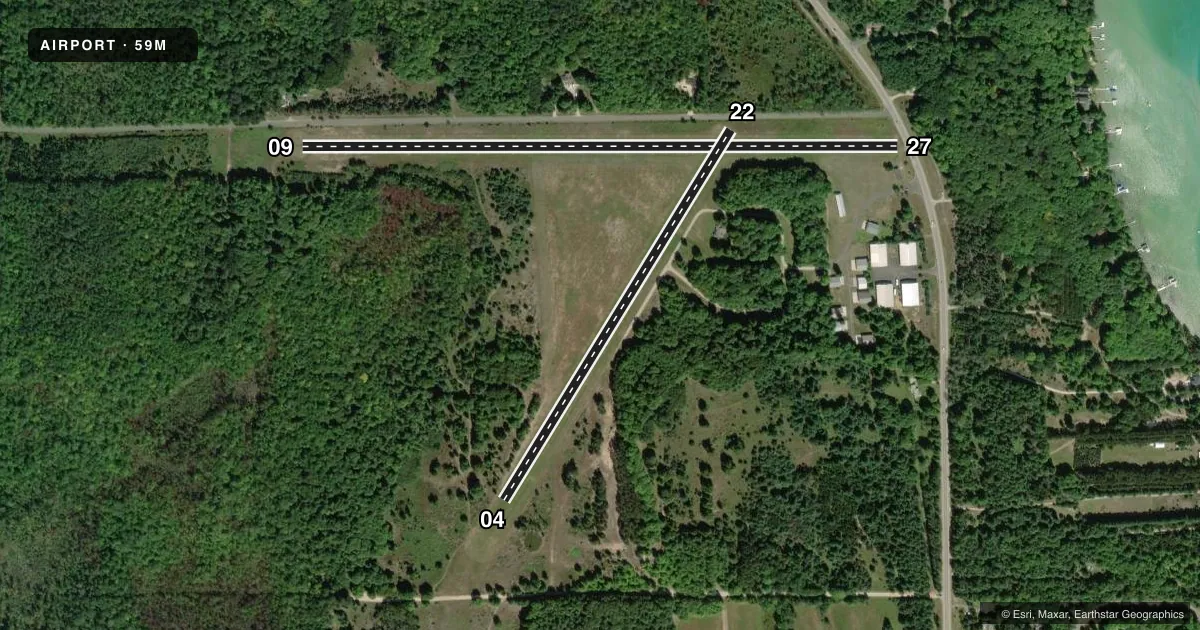
Runways & pattern
Full pagePattern entry · RWY 09
LEFT TRAFFIC| Runway | Heading (°M) | Length | Surface | Traffic |
|---|---|---|---|---|
| 09/27 | 86° / 266° | 3,300 ft | TURF | Standard L |
| 04/22 | 28° / 208° | 2,400 ft | TURF | Standard L |
Runway end performance
| End | TORA | TODA | ASDA | LDA | VGSI | Approach lights | Obstruction |
|---|---|---|---|---|---|---|---|
| 09 | — | — | — | — | — | — | 15', road, 0' from thr, 110' R of cntrln, slope 1 |
| 27 | — | — | — | — | — | — | 15', road, 0' from thr, 125' R of cntrln, slope 1 |
| 04 | — | — | — | — | — | — | 64', tree, 358' from thr, 150' R of cntrln, slope 5 |
| 22 | — | — | — | — | — | — | 15', road, 15' from thr, 125' R of cntrln, slope 1 |
Declared distances in feet. TORA = takeoff run available, TODA = takeoff distance, ASDA = accelerate-stop, LDA = landing distance.
Airport sketch
Runways drawn to scale from FAA survey coordinates, rendered over satellite imagery. Not for navigation.
Approaches & charts
Services on the field
Fuel grades, oxygen, maintenance, ramp storage and lighting — as declared to the FAA by the airport operator.
Fuel & services
- Fuel
- Not available
Ramp & ground
- Transient storage
- Tie-down
- Wind indicator
- Yes
- Segmented circle
- Yes
Fuel & FBOs
Cheapest 100LL and Jet A on the field and nearby. Always confirm with the FBO before taxi.
Airport notes
Surface conditions, obstructions, local procedures, lighting outages and other notes published with each FAA cycle.
General notes
- ARPT CLSD NOV 15-APR 15 & WHEN SNOW COVD EXC FOR SKI EQUIPPED ACFT. NO SNOW REMOVAL.
- TREES OBSC VIEW OF RWY ENDS.
- FOR CD CTC MINNEAPOLIS ARTCC AT 651-463-5588.
- DEER, BIRDS, & WILDLIFE ON & INVOF ARPT.
Approach & departure obstructions
- 04RWY & DTHR MKD WITH 3 FT YELLOW CONES.
- 093 FT YELLOW CONES.
- 22RWY & DTHR MKD WITH 3 FT YELLOW CONES.
- 27RWY & DTHR MKD WITH 3 FT YELLOW CONES.
- 04APCH RATIO 1:1 TO DTHR OVR 28 FT TREE, 17 FT DIST, 90 FT L.
- 22APCH RATIO 3:1 TO DTHR OVR 72 FT TREES, 236 FT DIST, 135 FT L.
- 27APCH RATIO 8:1 TO DTHR OVR 80 FT TREES, 658 FT DIST, 163 FT L.
Other notes
- PRVDD OBST IN RWY APCH SLP SFC REMOVED/LWRD OR THR DSPLCD & MKD TO PRVD MNM 20:1 APCH SFC CLNC OVR OBST; AREA 125 FT EITHER SIDE OF RCL CLEAR OF ANY OBST; ALL ASPECTS OF 89-AGL-671-NRA COMPLIED WITH; APVD FOR RWY 09/27 ONLY.
- OWNERARPT PHYS ADS: 1309 N US-31, KEWADIN, MI 49648.
- 09/27UNEVEN ROLLING TRRN.
VFR map & nearby airports
VFR sectional. Tap any ICAO chip to open that airport.
Key facts · 59M
Answer card- ICAO
- 59M
- Name
- TORCHPORT
- Location
- EASTPORT, MICHIGAN
- Elevation
- 640 ft MSL
- Traffic pattern altitude
- 1,640 ft MSL (1,000 AGL)
- Control tower
- Non-towered (use CTAF)
- Total runways
- 2
- Longest runway
- 09/27 · 3,300 ft
- Published ILS approaches
- 0
- Published frequencies
- 1
- Magnetic variation
- 4°
- Current flight rules
- VFR
- Current wind
- 000° at 0 kt
- Favored runway now
- –
Torchport Airport (59M) is in Eastport, Michigan. The field elevation is 640 ft MSL. It has two turf runways. The longest is runway 09/27 at 3,300 ft. There is no control tower. CTAF is 122.9. No ILS approaches are published.
Pattern altitude is not published, so use the standard 1,000 ft AGL for light piston traffic unless the current Chart Supplement says otherwise. The airport is closed November 15 through April 15. It is also closed when snow covered except for ski equipped aircraft. There is no snow removal. That matters here because this is a turf field with uneven rolling terrain and wildlife in the area. Trees can also block the view of the runway ends.
Runway 09/27 has published approach notes for obstacles near the displaced threshold. Runway 04/22 also has marked displaced threshold cones. The published remarks say clearance delivery is handled through Minneapolis ARTCC at 651-463-5588. No on-field FBOs are listed, so verify services with the airport operator or call ahead before you go.