METAR & TAF KCVX
Current METAR
Observed 20:15Z
KCVX 272015Z AUTO 30010KT 10SM CLR 25/21 A2971 RMK AO2
- Wind
- 300° @ 10 kt
- Visibility
- 10 SM
- Temp / Dew
- 25°C / 21°C
- Altimeter
- 29.71 inHg
- Clouds
- CLR
- Density alt
- 2,290 ft
- Ceiling
- Unlimited
- Rules
- VFR
Airport info & contacts
Manager on record, flight service, ARTCC, attendance schedule and pattern altitude — published by the FAA and refreshed every 28 days.
Location
- From city
- 1 NM SW
- VFR sectional
- GREEN BAY
- ARTCC
- ZMP · MINNEAPOLIS
- NOTAM facility
- CVX (NOTAM-D)
Airport manager
- Name
- ROBERT SCHOLEY
- Phone
- 231-547-3605
- Address
- 111 AIRPORT DR, CHARLEVOIX MI 49720-8904
Flight service · Hours
- FSS LAN
- LANSING1-800-WX-BRIEF
- Attendance
- 0800-1700
Frequencies
Tap any row to copy the frequency to your clipboard.
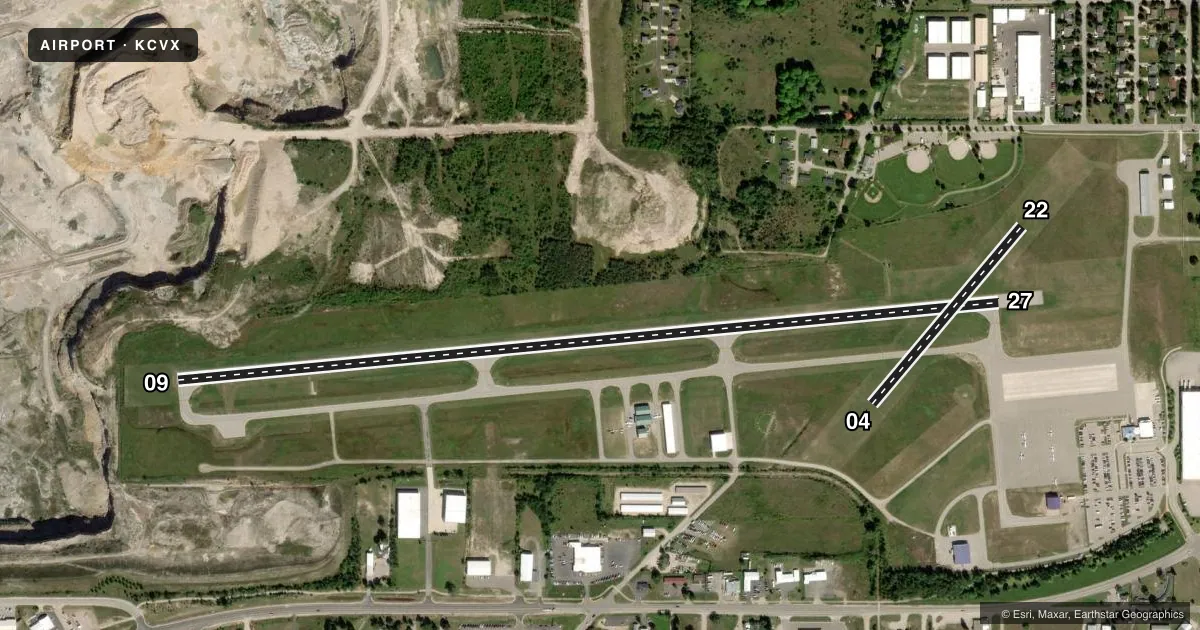
Runways & pattern
Full pagePattern entry · RWY 27
LEFT TRAFFIC| Runway | Heading (°M) | Length | Surface | Traffic |
|---|---|---|---|---|
| 09/27Favored | 80° / 260° | 4,549 ft | ASPH | Standard L |
| 04/22 | 35° / 215° | 1,280 ft | TURF | Standard L |
Runway end performance
| End | TORA | TODA | ASDA | LDA | VGSI | Approach lights | Obstruction |
|---|---|---|---|---|---|---|---|
| 09 | — | — | — | — | PAPI 4-box right(3°) | — | 6', brush, 277' from thr, 258' R of cntrln, slope 12 |
| 27 | — | — | — | — | PAPI 4-box right(3°) | — | 54', tree, 1265' from thr, 398' R of cntrln, slope 19 |
| 04 | — | — | — | — | — | — | 97', tree, 1902' from thr, 100' R of cntrln, slope 19 |
| 22 | — | — | — | — | — | — | 32', tree, 591' from thr, 192' R of cntrln, slope 18 |
Declared distances in feet. TORA = takeoff run available, TODA = takeoff distance, ASDA = accelerate-stop, LDA = landing distance.
Airport sketch
Runways drawn to scale from FAA survey coordinates, rendered over satellite imagery. Not for navigation.
Approaches & charts
Services on the field
Fuel grades, oxygen, maintenance, ramp storage and lighting — as declared to the FAA by the airport operator.
Fuel & services
- Fuel
- 100LLA+
- Airframe repair
- Major
- Power plant repair
- Major
- Other services
- CHTR,PAJA
Ramp & ground
- Transient storage
- Tie-down
- Landing fee
- Yes
- Customs
- Not available
- Lighting schedule
- SEE RMK
- Beacon schedule
- SS-SR
- Beacon
- White / Green (civil land)(WG)
- Wind indicator
- Lighted
- Segmented circle
- Yes
Fuel & FBOs
Cheapest 100LL and Jet A on the field and nearby. Always confirm with the FBO before taxi.
Airport notes
Surface conditions, obstructions, local procedures, lighting outages and other notes published with each FAA cycle.
General notes
- RWY 09/27 UPSLP FM EAST TO WEST, STEEPEST GRAD OCRS WEST THIRD OF RWY.
- DEER, BIRDS, & WILDLIFE ON & INVOF ARPT.
- -100 FT QUARRY/MINE, 300 FT FM RWY 09 THR.
- CHARLEVOIX VOLUNTARY QUIET HRS WEF 2300-0700 DLY.
- FOR CD CTC MINNEAPOLIS ARTCC AT 651-463-5588.
Lighting notes
- ACTVT REIL RWY 09 & 27; PAPI RWY 09 & 27; NSTD MIRL RWY 09/27 - CTAF.
Fuel notes
- 100LLFOR 100LL & JET A+ FUEL AFT HRS CALL AMGR.
Runway surface & condition
- 04/22CLSD NOV-APR.
- 09/27NSTD MIRL DUE TO RWY 27 THR LGTS LCTD OUTBOARD FM RWY EDGES.
Approach & departure obstructions
- 09PREFERRED LDG RWY 2300-0700.
- 27PREFERRED TKOF RWY 2300-0700.
- 043 FT YELLOW CONES.
- 223 FT YELLOW CONES.
Other notes
- ESTABD BFR 1959.
- LDG FEE WAIVED WITH MNM FUEL PURCHASE.
- 2UNATNDD MAJOR HOLS.
- MANAGERASST AMGR: RUSS MCCRANEY.
VFR map & nearby airports
VFR sectional. Tap any ICAO chip to open that airport.
Key facts · KCVX
Answer card- ICAO
- KCVX
- Name
- CHARLEVOIX MUNI
- Location
- CHARLEVOIX, MICHIGAN
- Elevation
- 668.9 ft MSL
- Traffic pattern altitude
- 1,668.9 ft MSL (1,000 AGL)
- Control tower
- Non-towered (use CTAF)
- Total runways
- 2
- Longest runway
- 09/27 · 4,549 ft
- Published ILS approaches
- 0
- Published frequencies
- 2
- Magnetic variation
- 5°
- Current flight rules
- VFR
- Current wind
- 300° at 10 kt
- Favored runway now
- RWY 27
Charlevoix Muni sits in Charlevoix, Michigan. The field elevation is 668.9 ft MSL. It has two runways. The longest is 09/27 at 4,549 ft. Runway 04/22 is 1,280 ft of turf. There is no control tower. CTAF and UNICOM are both 122.8.
No ILS approaches are published here. Pattern altitude is not published, so use the standard 1,000 ft AGL for light piston operations unless the current Chart Supplement says otherwise. The on-field FBO is Charlevoix Municipal Airport. It carries 100LL and Jet A with Prist. Call (231) 547-3605 for current service details. The airport also notes that the landing fee is waived with a minimum fuel purchase.
A few operational items matter here. Runway 09/27 slopes up from east to west. The steepest part is on the west third of the runway. There is a 100-foot quarry or mine about 300 feet from the threshold of runway 09. Deer and birds are reported on and near the airport. Runway 04/22 is closed from November through April. Charlevoix voluntary quiet hours run from 2300 to 0700 daily. For clearance delivery, contact Minneapolis ARTCC at 651-463-5588. The airport is unattended on major holidays. Check the current Chart Supplement before you go.