METAR & TAF KMGN
Current METAR
Observed 18:22Z
KMGN 271822Z AUTO 12004KT 10SM SCT018 28/22 RMK AO2
- Wind
- 120° @ 4 kt
- Visibility
- 10 SM
- Temp / Dew
- 28°C / 22°C
- Altimeter
- —
- Clouds
- SCT
- Density alt
- 2,410 ft
- Ceiling
- Unlimited
- Rules
- VFR
Airport info & contacts
Manager on record, flight service, ARTCC, attendance schedule and pattern altitude — published by the FAA and refreshed every 28 days.
Location
- From city
- 3 NM E
- VFR sectional
- LAKE HURON
- ARTCC
- ZMP · MINNEAPOLIS
- NOTAM facility
- MGN (NOTAM-D)
Airport manager
- Name
- MARK ZABAWA
- Phone
- 231-206-9333
- Address
- 8350 M-119, HARBOR SPRINGS MI 49740-9077
Flight service · Hours
- FSS LAN
- LANSING1-800-WX-BRIEF
- Attendance
- 0800-DUSK
Frequencies
Tap any row to copy the frequency to your clipboard.
Runways & pattern
Full pagePattern entry · RWY 10
LEFT TRAFFICRunway end performance
| End | TORA | TODA | ASDA | LDA | VGSI | Approach lights | Obstruction |
|---|---|---|---|---|---|---|---|
| 10 | — | — | — | — | PAPI 4-box right(3.5°) | — | 36', tree, 200' from thr, 112' R of cntrln, slope 0 |
| 28 | — | — | — | — | PAPI 4-box left(4°) | — | 60', pole, 237' from thr, 165' R of cntrln, slope 0 |
Declared distances in feet. TORA = takeoff run available, TODA = takeoff distance, ASDA = accelerate-stop, LDA = landing distance.
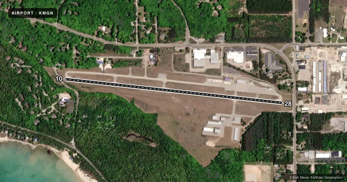
Airport sketch
Runways drawn to scale from FAA survey coordinates, rendered over satellite imagery. Not for navigation.
Approaches & charts
Services on the field
Fuel grades, oxygen, maintenance, ramp storage and lighting — as declared to the FAA by the airport operator.
Fuel & services
- Fuel
- 100LLA+
Ramp & ground
- Transient storage
- Tie-down
- Landing fee
- Yes
- Customs
- Not available
- Lighting schedule
- SEE RMK
- Beacon schedule
- SS-SR
- Beacon
- White / Green (civil land)(WG)
- Wind indicator
- Lighted
- Segmented circle
- No
Fuel & FBOs
Cheapest 100LL and Jet A on the field and nearby. Always confirm with the FBO before taxi.
Airport notes
Surface conditions, obstructions, local procedures, lighting outages and other notes published with each FAA cycle.
General notes
- RWY 10 APCH AREA HAS TWO 70 FT LGTD OBSTN POLES, 170 FT LEFT OF CNTRLN; +75 FT TREES ON NORTH SIDE.
- RWY 28 APCH AREA HAS LGTD OBSTN POLES, 165 FT LEFT & 220 FT RIGHT OF CNTRLN; +80 FT TREES ADJ.
- DEER, BIRDS, & WILDLIFE ON & INVOF ARPT.
- NOISE ABATEMENT PROCS: NO TURBOJET/TURBOFAN ACFT DEPS 2300-0700; NO LOW FLT OVR SRNDG COMMUNITY; ALL ACFT DEPG TO THE WEST TURN SOUTH OVR THE WATER AS SOON AS PRACTICAL.
- FOR CD CTC MINNEAPOLIS ARTCC AT 651-463-5588.
Lighting notes
- ACTVT MIRL RWY 10/28 - CTAF. PAPI RWY 10 & 28 OPR CONSLY.
Approach & departure obstructions
- 104 FT FENCE, 0 FT DIST, 48 FT R; 15 FT ROAD, 0 FT DIST, 75 FT R; 70 FT LGTD POLE, 180 FT DIST, 240 FT R.
- 284 FT FENCE, 199 FT DIST; 70 FT TREES, 0 FT DIST, 168 FT L.
- 28PAPI UNUSBL BYD 2 DEGS LEFT OF CNTRLN.
- 10APCH RATIO 1:1 TO DTHR OVR 80 FT TREES, 80 FT DIST, 261 FT L.
- 28APCH RATIO 0:1 TO DTHR OVR 70 FT POLE, 0 FT DIST, 250 FT L.
Other notes
- LDG FEE WAIVED WITH MNM FUEL PURCHASE.
- MANAGERCELL.
VFR map & nearby airports
VFR sectional. Tap any ICAO chip to open that airport.
Key facts · KMGN
Answer card- ICAO
- KMGN
- Name
- HARBOR SPRINGS
- Location
- HARBOR SPRINGS, MICHIGAN
- Elevation
- 685.8 ft MSL
- Traffic pattern altitude
- 1,685.8 ft MSL (1,000 AGL)
- Control tower
- Non-towered (use CTAF)
- Total runways
- 1
- Longest runway
- 10/28 · 4,149 ft
- Published ILS approaches
- 0
- Published frequencies
- 2
- Magnetic variation
- 5°
- Current flight rules
- VFR
- Current wind
- 120° at 4 kt
- Favored runway now
- RWY 10
Harbor Springs Airport (KMGN) sits in Harbor Springs, Michigan. Field elevation is 685.8 ft MSL. The airport has one runway. Runway 10/28 is 4,149 ft long with an asphalt surface. There is no control tower. CTAF and UNICOM are both 122.8.
No ILS approaches are published here. Pattern altitude is not published, so use the standard 1,000 ft AGL for light piston traffic unless the current FAA Chart Supplement says otherwise. The on-field FBO is Harbor Springs Airport. It carries 100LL and Jet A. Call (231) 347-2812 for current services before you go.
This field has a few things a first-time pilot should plan for. Noise abatement is active. Turbojet and turbofan departures are not allowed between 2300 and 0700. Departing westbound aircraft should turn south over the water as soon as practical. Low flight over the surrounding community is not allowed. Runway 28 has published obstruction and PAPI limitations near the approach end. Birds and deer are also reported on and near the airport. If you need clearance delivery, contact Minneapolis ARTCC at 651-463-5588.