METAR & TAF KPLN
Current METAR
Observed 20:54Z
KPLN 272054Z AUTO 27003KT 10SM BKN028 BKN033 28/22 A2968 RMK AO2 SLP047 T02780222 58002
- Wind
- 270° @ 3 kt
- Visibility
- 10 SM
- Temp / Dew
- 28°C / 22°C
- Altimeter
- 29.68 inHg
- Clouds
- BKN
- Density alt
- 2,751 ft
- Ceiling
- 2,800 ft AGL
- Rules
- MVFR
Airport info & contacts
Manager on record, flight service, ARTCC, attendance schedule and pattern altitude — published by the FAA and refreshed every 28 days.
Location
- From city
- 1 NM NW
- VFR sectional
- LAKE HURON
- ARTCC
- ZMP · MINNEAPOLIS
- NOTAM facility
- PLN (NOTAM-D)
Airport manager
- Name
- JEFF MALLORY
- Phone
- 231-539-8442
- Address
- 1395 N US HIGHWAY 31, PELLSTON MI 49769-9307
Flight service · Hours
- FSS LAN
- LANSING1-800-WX-BRIEF
- Attendance
- 0600-2300
Frequencies
Tap any row to copy the frequency to your clipboard.
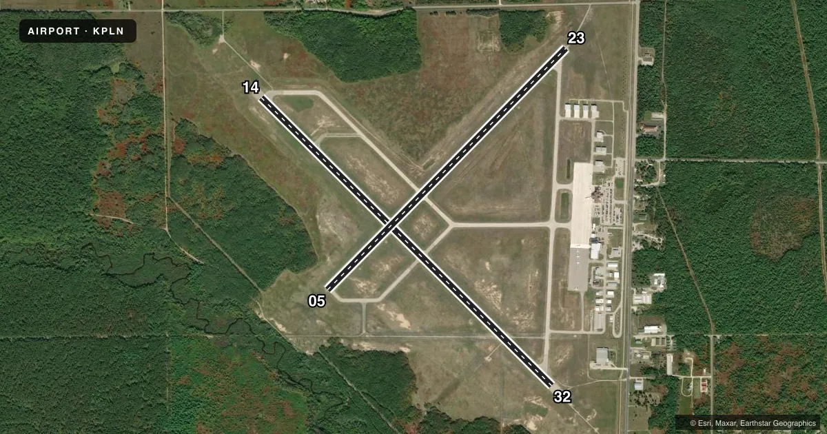
Runways & pattern
Full pagePattern entry · RWY 32
LEFT TRAFFIC| Runway | Heading (°M) | Length | Surface | Traffic |
|---|---|---|---|---|
| 14/32Favored | 129° / 309° | 6,513 ft | ASPH | Standard L |
| 05/23 | 39° / 219° | 5,401 ft | ASPH | Standard L |
Runway end performance
| End | TORA | TODA | ASDA | LDA | VGSI | Approach lights | Obstruction |
|---|---|---|---|---|---|---|---|
| 14 | 6,513' | 6,513' | 6,512' | 6,512' | PAPI 4-box left(3°) | — | 82', trees, 2850' from thr, 0' R of cntrln, slope 32 |
| 32 | 6,513' | 6,513' | 6,513' | 6,513' | — | MALSR | 56', tree, 2739' from thr, 865' R of cntrln, slope 45 |
| 05 | 5,395' | 5,395' | 5,395' | 5,395' | VASI 4-box right(3°) | — | 50', trees, 1500' from thr, 300' R of cntrln, slope 26 |
| 23 | 5,395' | 5,395' | 5,395' | 5,395' | VASI 4-box left(3°) | — | 18', road, 669' from thr, 316' R of cntrln, slope 26 |
Declared distances in feet. TORA = takeoff run available, TODA = takeoff distance, ASDA = accelerate-stop, LDA = landing distance.
Airport sketch
Runways drawn to scale from FAA survey coordinates, rendered over satellite imagery. Not for navigation.
Approaches & charts
ILS · 1
Services on the field
Fuel grades, oxygen, maintenance, ramp storage and lighting — as declared to the FAA by the airport operator.
Fuel & services
- Fuel
- 100LLA+
- Oxygen (bottled)
- Not available
- Oxygen (bulk)
- Not available
- Airframe repair
- Major
- Power plant repair
- Major
- Other services
- CHTR
Ramp & ground
- Transient storage
- Tie-down
- Landing fee
- Yes
- Customs
- Not available
- Lighting schedule
- SEE RMK
- Beacon schedule
- SS-SR
- Beacon
- White / Green (civil land)(WG)
- Wind indicator
- Lighted
- Segmented circle
- Yes
Fuel & FBOs
Cheapest 100LL and Jet A on the field and nearby. Always confirm with the FBO before taxi.
Airport notes
Surface conditions, obstructions, local procedures, lighting outages and other notes published with each FAA cycle.
General notes
- DEER & GULLS OCNLY ON & INVOF ARPT.
- BE ALERT FOR SNOW REMOVAL EQUIP & ACTIVITY ON & INVOF RYS DURG WINTER MONTHS.
- TWY B1 & E1 CLSD 1 NOV THRU 15 APR..
- SFC CONDS UNMON 2300-0530 DLY.
- FOR CD IF UNA TO CTC ON FSS FREQ, CTC MINNEAPOLIS ARTCC AT 651-463-5588.
Lighting notes
- ACTVT MALSR RWY 32; REIL RWY 14, 05, & 23; PAPI RWY 14; HIRL RWY 14/32; MIRL RWY 05/23 - CTAF. VASI RWY 05 & 23 OPR CONSLY.
Runway surface & condition
- 05/23PCR VALUE: 290/F/B/X/T
- 14/32PCR VALUE: 290/F/B/X/T
Approach & departure obstructions
- 14UNUSBL BYD 8 DEGS RIGHT OF CNTRLN.
Other notes
- ARPT CLSD TO UNSKED ACR ACFT WITH MORE THAN 30 PSGR SEATS EXCP 24 HR PPR.
- FAC FEE WAIVED WITH MNM FUEL PURCHASE.
VFR map & nearby airports
VFR sectional. Tap any ICAO chip to open that airport.
Key facts · KPLN
Answer card- ICAO
- KPLN
- Name
- PELLSTON RGNL/EMMET COUNTY
- Location
- PELLSTON, MICHIGAN
- Elevation
- 720.6 ft MSL
- Traffic pattern altitude
- 1,720.6 ft MSL (1,000 AGL)
- Control tower
- Non-towered (use CTAF)
- Total runways
- 2
- Longest runway
- 14/32 · 6,513 ft
- Published ILS approaches
- 1
- Published frequencies
- 2
- Magnetic variation
- 6°
- Current flight rules
- MVFR
- Current wind
- 270° at 3 kt
- Favored runway now
- RWY 32
Pellston Rgnl/Emmet County is in Pellston, Michigan. The field elevation is 720.6 ft MSL. It has two asphalt runways. The longest is runway 14/32 at 6,513 ft. There is no control tower. CTAF and UNICOM are both 123.0.
One ILS approach is published for runway 32. Pattern altitude is not published in the facts, so use the standard 1,000 ft AGL for light piston traffic unless the current FAA Chart Supplement says otherwise. The on-field FBO is Pellston Regional Airport. It carries 100LL and Jet A. Call them at (231) 539-8442 for current services.
A few operational items matter here. Runway 32 has MALSR lighting. Runway 14 has high intensity lighting plus a PAPI. REIL is available on runways 14, 05 and 23. Runways 05 and 23 have medium intensity lighting. All lighting is controlled by CTAF. In winter, watch for snow removal equipment on and near the runways. Taxiways B1 and E1 close from November 1 through April 15. Deer and gulls are also reported at the airport. Runway 14 is unusable beyond 8 degrees right of centerline. If you are bringing a larger aircraft, note the published restriction for unscheduled aircraft with more than 30 passenger seats. Check the current FAA Chart Supplement for any current details before you go.