METAR & TAF 2M7
2M7 does not publish a METAR.
Showing the nearest reporting station: KSLH (CHEBOYGAN COUNTY) · 11.5 NM away. Conditions at 2M7 may differ.
METAR · KSLH
Observed 18:55Z
KSLH 271855Z AUTO VRB05KT 10SM OVC011 25/21 A2969 RMK AO2
- Wind
- VAR @ 5 kt
- Visibility
- 10 SM
- Temp / Dew
- 25°C / 21°C
- Altimeter
- 29.69 inHg
- Clouds
- OVC
- Density alt
- 2,325 ft
- Ceiling
- 1,100 ft AGL
- Rules
- MVFR
Airport info & contacts
Manager on record, flight service, ARTCC, attendance schedule and pattern altitude — published by the FAA and refreshed every 28 days.
Location
- From city
- 11 NM SE
- VFR sectional
- LAKE HURON
- ARTCC
- ZMP · MINNEAPOLIS
- NOTAM facility
- LAN (NOTAM-D)
Airport manager
- Name
- ALLEN D HOFFMAN
- Phone
- 231-625-2418
- Address
- 9341 TWIN LAKES RD, CHEBOYGAN MI 49721-9548
Flight service · Hours
- FSS LAN
- LANSING1-800-WX-BRIEF
- Attendance
- IREG
Frequencies
Tap any row to copy the frequency to your clipboard.
Runways & pattern
Full pagePattern entry · RWY 33
LEFT TRAFFICRunway end performance
| End | TORA | TODA | ASDA | LDA | VGSI | Approach lights | Obstruction |
|---|---|---|---|---|---|---|---|
| 15 | — | — | — | — | — | — | 52', trees, 10' from thr, 80' R of cntrln, slope 0 |
| 33 | — | — | — | — | — | — | 43', trees, 10' from thr, 105' R of cntrln, slope 0 |
Declared distances in feet. TORA = takeoff run available, TODA = takeoff distance, ASDA = accelerate-stop, LDA = landing distance.
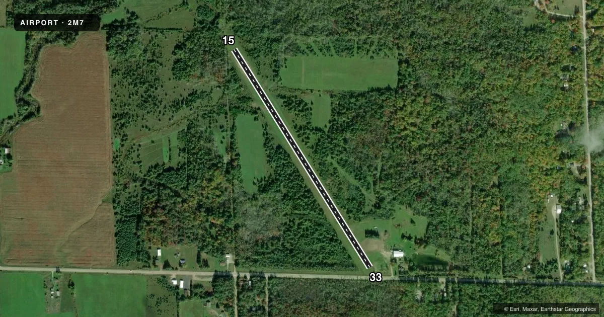
Airport sketch
Runways drawn to scale from FAA survey coordinates, rendered over satellite imagery. Not for navigation.
Approaches & charts
Services on the field
Fuel grades, oxygen, maintenance, ramp storage and lighting — as declared to the FAA by the airport operator.
Fuel & services
- Fuel
- Not available
- Airframe repair
- Major
- Power plant repair
- Major
Ramp & ground
- Transient storage
- Hangar
- Wind indicator
- Yes
- Segmented circle
- No
Fuel & FBOs
Cheapest 100LL and Jet A on the field and nearby. Always confirm with the FBO before taxi.
Airport notes
Surface conditions, obstructions, local procedures, lighting outages and other notes published with each FAA cycle.
General notes
- RWY 15/33: DITCH ON BOTH SIDES OF RWY.
- FOR CD CTC MINNEAPOLIS ARTCC AT 651-463-5588.
Approach & departure obstructions
- 153 FT YELLOW CONES.
- 333 FT YELLOW CONES.
- 15CTLG OBSTN EXCEEDS A 45 DEG SLP.
- 33APCH RATIO 20:1 TO DTHR OVR +88 FT TREES, 1774 FT DIST, 0 FT B.
- 33ALSO +17 FT ROAD, 43 FT DIST, 125 FT R.
Other notes
- PRVDD THE AREA 125 FT EITHER SIDE & 200 FT BYD RWY ENDS IS CLEAR; ANY OBSTNS IN THE APCH ARE LWRD/REMOVED OR THRS DSPLCD TO PRVD A CLEAR 20:1 APCH.
- 15/33ROUGH, UNEVEN, & TIRE RUTS. SOFT WHEN WET - CALL AMGR TO CFM RWY CONDS.
VFR map & nearby airports
VFR sectional. Tap any ICAO chip to open that airport.
Key facts · 2M7
Answer card- ICAO
- 2M7
- Name
- HOFFMAN'S BLACK MOUNTAIN AERODROME
- Location
- CHEBOYGAN, MICHIGAN
- Elevation
- 677 ft MSL
- Traffic pattern altitude
- 1,677 ft MSL (1,000 AGL)
- Control tower
- Non-towered (use CTAF)
- Total runways
- 1
- Longest runway
- 15/33 · 2,800 ft
- Published ILS approaches
- 0
- Published frequencies
- 2
- Magnetic variation
- 6°
- Current flight rules
- MVFR
- Current wind
- 000° at 5 kt
- Favored runway now
- RWY 33
Hoffman's Black Mountain Aerodrome sits near Cheboygan, Michigan. Field elevation is 677 ft MSL. The airport has one runway, 15/33 and the longest runway is 2,800 ft. It is a turf strip. There is no control tower. CTAF and UNICOM are both 122.8. No ILS approaches are published.
Pattern altitude is not published. Use the standard 1,000 ft AGL for light piston operations unless the current FAA Chart Supplement says otherwise. That puts the traffic pattern at 1,677 ft MSL based on the field elevation in the facts block. The runway is marked with 3-foot yellow cones. Published remarks also note a rough and uneven surface with tire ruts. It can be soft when wet. Call the airport manager to confirm runway conditions before you go.
The published remarks show several obstructions near both ends. Runway 33 has a road close to the threshold. Runway 33 also has tall trees on the approach path. Runway 15 has a cataloged obstruction that exceeds a 45-degree slope. The runway also has a ditch on both sides. There are no on-field FBOs listed. If you need current field services, contact the airport operator directly or call the field on CTAF or UNICOM. For clearance delivery, contact Minneapolis ARTCC at 651-463-5588.