METAR & TAF KPZQ
Current METAR
Observed 16:35Z
KPZQ 271635Z AUTO 20003KT 9SM OVC010 23/21 A2973 RMK AO2
- Wind
- 200° @ 3 kt
- Visibility
- 9 SM
- Temp / Dew
- 23°C / 21°C
- Altimeter
- 29.73 inHg
- Clouds
- OVC
- Density alt
- 2,027 ft
- Ceiling
- 1,000 ft AGL
- Rules
- MVFR
Airport info & contacts
Manager on record, flight service, ARTCC, attendance schedule and pattern altitude — published by the FAA and refreshed every 28 days.
Location
- From city
- 1 NM S
- VFR sectional
- LAKE HURON
- ARTCC
- ZMP · MINNEAPOLIS
- NOTAM facility
- PZQ (NOTAM-D)
Airport manager
- Name
- ALAN STILLER
- Phone
- 906-430-7718
- Address
- 151 E HURON AVE, PO BOX 110, ROGERS CITY MI 49779-0110
Flight service · Hours
- FSS LAN
- LANSING1-800-WX-BRIEF
- Attendance
- MON-SAT · 0800-1400
Frequencies
Tap any row to copy the frequency to your clipboard.
Runways & pattern
Full pagePattern entry · RWY 27
LEFT TRAFFICRunway end performance
| End | TORA | TODA | ASDA | LDA | VGSI | Approach lights | Obstruction |
|---|---|---|---|---|---|---|---|
| 09 | — | — | — | — | PAPI 4-box left(3°) | — | 8', fence, 200' from thr, 250' R of cntrln, slope 1 |
| 27 | — | — | — | — | PAPI 4-box left(3°) | — | 12', sign, 299' from thr, 193' R of cntrln, slope 8 |
Declared distances in feet. TORA = takeoff run available, TODA = takeoff distance, ASDA = accelerate-stop, LDA = landing distance.
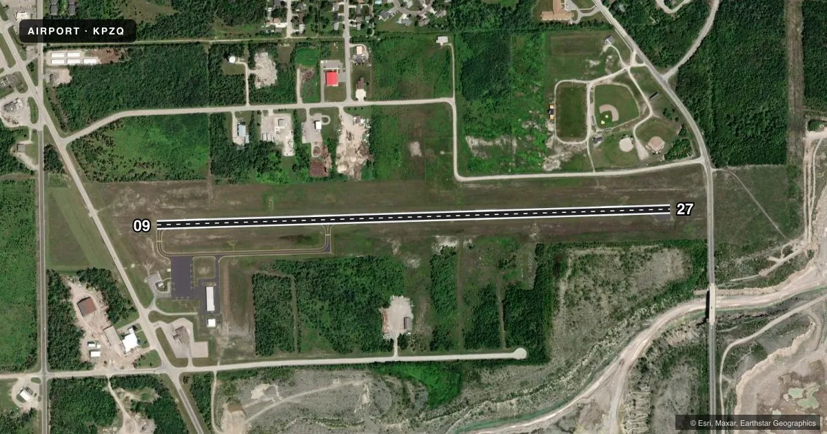
Airport sketch
Runways drawn to scale from FAA survey coordinates, rendered over satellite imagery. Not for navigation.
Approaches & charts
Services on the field
Fuel grades, oxygen, maintenance, ramp storage and lighting — as declared to the FAA by the airport operator.
Fuel & services
- Fuel
- 100LL
- Oxygen (bottled)
- Not available
- Oxygen (bulk)
- Not available
- Airframe repair
- Not available
- Power plant repair
- Not available
Ramp & ground
- Transient storage
- Tie-down
- Hangar
- Landing fee
- No fee published
- Customs
- Not available
- Lighting schedule
- SEE RMK
- Beacon schedule
- SS-SR
- Beacon
- White / Green (civil land)(WG)
- Wind indicator
- Lighted
- Segmented circle
- Yes
Fuel & FBOs
Cheapest 100LL and Jet A on the field and nearby. Always confirm with the FBO before taxi.
Airport notes
Surface conditions, obstructions, local procedures, lighting outages and other notes published with each FAA cycle.
General notes
- DEER, BIRDS, & WILDLIFE ON & INVOF ARPT.
- CALL AMGR TO VFY SNOW REMOVAL & WINTER CONDS.
- TRML BLDG ACES: PRESS 5-3-2-1.
- FOR CD CTC MINNEAPOLIS ARTCC AT 651-463-5588.
Lighting notes
- ACTVT REIL RWY 09 & 27; PAPI RWY 09 & 27; MIRL RWY 09/27 - CTAF.
Fuel notes
- 100LLFUEL AVBL O/R CALL AMGR.
Approach & departure obstructions
- 09PAPI UNUSBL BYD 9 DEGS LEFT OR RIGHT OF CNTRLN.
- 09APCH RATIO 20:1 TO DTHR.
- 27APCH RATIO 20:1 TO DTHR OVR +42 FT MKD/LGTD PLINES, 1040 DIST.
Other notes
- ESTABD BFR 1959.
- MANAGERAFT HRS CELL.
VFR map & nearby airports
VFR sectional. Tap any ICAO chip to open that airport.
Key facts · KPZQ
Answer card- ICAO
- KPZQ
- Name
- PRESQUE ISLE COUNTY
- Location
- ROGERS CITY, MICHIGAN
- Elevation
- 670.3 ft MSL
- Traffic pattern altitude
- 1,670.3 ft MSL (1,000 AGL)
- Control tower
- Non-towered (use CTAF)
- Total runways
- 1
- Longest runway
- 09/27 · 4,106 ft
- Published ILS approaches
- 0
- Published frequencies
- 3
- Magnetic variation
- 7°
- Current flight rules
- MVFR
- Current wind
- 200° at 3 kt
- Favored runway now
- RWY 27
Presque Isle County Airport is in Rogers City, Michigan. The field elevation is 670.3 ft MSL. It has one runway, 09/27, which is 4,106 ft long. There is no control tower. CTAF is 122.9. Approach and departure service is handled by Alpena on 128.425 or 379.3.
No ILS approaches are published here. The pattern altitude is not published in the facts, so use the standard 1,000 ft AGL for light piston traffic unless the current Chart Supplement says otherwise. The runway has medium intensity lights. Runway end identifier lights are installed on 09 and 27. PAPI is installed on both ends. The published remarks also note a marked and lighted power line near the 27 approach. The 09 PAPI is unusable more than 9 degrees left or right of centerline.
There are no on-field FBOs listed. 100LL is available on request by calling the airport manager. After hours, contact the manager on the cell phone. The airport manager should also be called to verify snow removal and winter conditions. Deer, birds and other wildlife are reported on and near the airport. For clearance delivery, contact Minneapolis ARTCC at 651-463-5588. If you are planning a first visit, treat this as an uncontrolled field with local lighting and a few published obstacles. Review the current Chart Supplement before departure.