METAR & TAF Y93
Y93 does not publish a METAR.
Showing the nearest reporting station: KGLR (GAYLORD RGNL) · 24.5 NM away. Conditions at Y93 may differ.
METAR · KGLR
Observed 20:53Z
KGLR 272053Z AUTO 27008KT 10SM SCT033 28/20 A2971 RMK AO2 SLP052 T02830200 55004
- Wind
- 270° @ 8 kt
- Visibility
- 10 SM
- Temp / Dew
- 28°C / 20°C
- Altimeter
- 29.71 inHg
- Clouds
- SCT
- Density alt
- 2,912 ft
- Ceiling
- Unlimited
- Rules
- VFR
Airport info & contacts
Manager on record, flight service, ARTCC, attendance schedule and pattern altitude — published by the FAA and refreshed every 28 days.
Location
- From city
- 1 NM SE
- VFR sectional
- LAKE HURON
- ARTCC
- ZMP · MINNEAPOLIS
- NOTAM facility
- LAN (NOTAM-D)
Airport manager
- Name
- DALE LA CLAIR
- Phone
- 989-306-6408
- Address
- 11746 COUNTY ROAD 487, ATLANTA MI 49709-9204
Flight service · Hours
- FSS LAN
- LANSING1-800-WX-BRIEF
- Attendance
- ON CALL
Frequencies
Tap any row to copy the frequency to your clipboard.
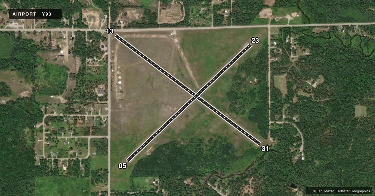
Runways & pattern
Full pagePattern entry · RWY 31
LEFT TRAFFIC| Runway | Heading (°M) | Length | Surface | Traffic |
|---|---|---|---|---|
| 13/31Favored | 121° / 301° | 3,223 ft | TURF | Standard L |
| 05/23 | 41° / 221° | 3,000 ft | ASPH | Standard L |
Runway end performance
| End | TORA | TODA | ASDA | LDA | VGSI | Approach lights | Obstruction |
|---|---|---|---|---|---|---|---|
| 13 | — | — | — | — | — | — | 16', road, 0' from thr, 93' R of cntrln, slope 0 |
| 31 | — | — | — | — | — | — | 26', trees, 0' from thr, 125' R of cntrln, slope 0 |
| 05 | — | — | — | — | — | — | 83', trees, 409' from thr, 160' R of cntrln, slope 2 |
| 23 | — | — | — | — | PAPI 2-box left(4°) | — | 12', road, 316' from thr, 135' R of cntrln, slope 9 |
Declared distances in feet. TORA = takeoff run available, TODA = takeoff distance, ASDA = accelerate-stop, LDA = landing distance.
Airport sketch
Runways drawn to scale from FAA survey coordinates, rendered over satellite imagery. Not for navigation.
Approaches & charts
Services on the field
Fuel grades, oxygen, maintenance, ramp storage and lighting — as declared to the FAA by the airport operator.
Fuel & services
- Fuel
- Not available
Ramp & ground
- Transient storage
- Tie-down
- Landing fee
- No fee published
- Customs
- Not available
- Lighting schedule
- SEE RMK
- Wind indicator
- Lighted
- Segmented circle
- Yes
Fuel & FBOs
Cheapest 100LL and Jet A on the field and nearby. Always confirm with the FBO before taxi.
Airport notes
Surface conditions, obstructions, local procedures, lighting outages and other notes published with each FAA cycle.
General notes
- FOR CD CTC MINNEAPOLIS ARTCC AT 651-463-5588.
- DEER & LRG BIRDS ON & INVOF ARPT.
- RWY 13/31 CLSD NOV-APR & WHEN SN COVD.
Lighting notes
- ACTVT PAPI RWY 23; LIRL RWY 05/23 & 13/31 - CTAF.
Runway surface & condition
- 05/23CFM WINTER CONDS & SNOW REMOVAL PRIOR TO USE - CALL AMGR OR ASST AMGR.
- 13/31CLSD NOV-APR & WHEN SNOW COVD. NO SNOW REMOVAL.
- 13/31LIRL OPRS JUN-SEP.
Approach & departure obstructions
- 05FADED.
- 23FADED.
- 13YELLOW CONES.
- 05APCH RATIO 20:1 TO DTHR.
- 13CTLNG OBSTN EXCEEDS 45 DEG SLP. APCH RATIO 20:1 TO DTHR.
- 23APCH RATIO 16:1 TO DTHR. + 58 FT TREE, 943 FT DIST, 125 FT L.
- 31CTLNG OBSTN EXCEEDS 45 DEG SLP. APCH RATIO 16:1 TO DTHR. + 57 FT TREE, 925 FT DIST, 20 FT R.
Other notes
- NON-COMPLIANCE WITH FAR 157.
- 1FOR SVC CTC AMGR.
- MANAGERASST AMGR 989-306-0926.
- OWNERBRILEY TWP OFC.
VFR map & nearby airports
VFR sectional. Tap any ICAO chip to open that airport.
Key facts · Y93
Answer card- ICAO
- Y93
- Name
- ATLANTA MUNI
- Location
- ATLANTA, MICHIGAN
- Elevation
- 880 ft MSL
- Traffic pattern altitude
- 1,880 ft MSL (1,000 AGL)
- Control tower
- Non-towered (use CTAF)
- Total runways
- 2
- Longest runway
- 13/31 · 3,223 ft
- Published ILS approaches
- 0
- Published frequencies
- 1
- Magnetic variation
- 6°
- Current flight rules
- VFR
- Current wind
- 270° at 8 kt
- Favored runway now
- RWY 31
Atlanta Muni is in Atlanta, Michigan. The field sits at 880 ft MSL. It has two runways. The longest is runway 13/31 at 3,223 ft. There is no control tower. CTAF is 122.9. No ILS approaches are published.
Pattern altitude is not published. Use 1,000 ft AGL for light piston operations unless the current Chart Supplement says otherwise. That puts the standard pattern at 1,880 ft MSL. Runway 05/23 is asphalt at 3,000 ft. Runway 13/31 is turf at 3,223 ft. Published remarks note tree obstructions near the approach paths. Runway 23 has a PAPI. Low-intensity runway lights for both runways are activated by CTAF. Runway 13/31 is closed from November through April. It is also closed when snow covered. No snow removal is provided.
This is a non-towered field with wildlife in the area. Deer and large birds are reported on and near the airport. Runway 05 markings are faded. Check the current Chart Supplement before departure for any changes to runway status, winter conditions, or other local procedures. For service, contact the manager. The assistant manager phone number listed in the remarks is 989-306-0926.