METAR & TAF 51M
51M does not publish a METAR.
Showing the nearest reporting station: KGOV (GRAYLING AAF) · 25.9 NM away. Conditions at 51M may differ.
METAR · KGOV
Observed 15:55Z
KGOV 241555Z AUTO 22008KT 10SM FEW043 23/13 A3016 RMK AO2 SLP218 T02330129 $
- Wind
- 220° @ 8 kt
- Visibility
- 10 SM
- Temp / Dew
- 23°C / 13°C
- Altimeter
- 30.16 inHg
- Clouds
- FEW
- Density alt
- 1,943 ft
- Ceiling
- Unlimited
- Rules
- VFR
Airport info & contacts
Manager on record, flight service, ARTCC, attendance schedule and pattern altitude — published by the FAA and refreshed every 28 days.
Location
- From city
- 2 NM N
- VFR sectional
- LAKE HURON
- ARTCC
- ZMP · MINNEAPOLIS
- NOTAM facility
- LAN (NOTAM-D)
Airport manager
- Name
- BRIAN SMUTEK
- Phone
- 989-619-6484
- Address
- 245 S MOUNT TOM RD, MIO MI 48647-9366
Flight service · Hours
- FSS LAN
- LANSING1-800-WX-BRIEF
- Attendance
- Unattended
Frequencies
Tap any row to copy the frequency to your clipboard.
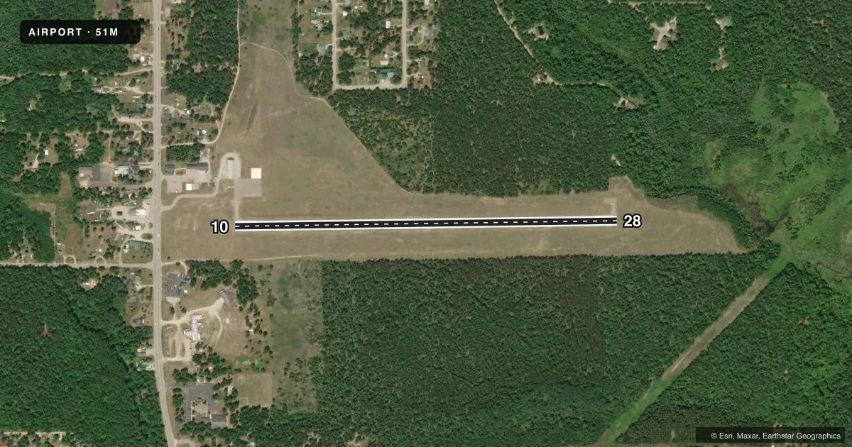
Runways & pattern
Full pagePattern entry · RWY 28
LEFT TRAFFICRunway end performance
| End | TORA | TODA | ASDA | LDA | VGSI | Approach lights | Obstruction |
|---|---|---|---|---|---|---|---|
| 10 | — | — | — | — | PAPI 4-box left(3°) | — | 40', trees, 952' from thr, 26' R of cntrln, slope 18 |
| 28 | — | — | — | — | PAPI 4-box left(4°) | — | 10', brush, 308' from thr, 137' R of cntrln, slope 10 |
Declared distances in feet. TORA = takeoff run available, TODA = takeoff distance, ASDA = accelerate-stop, LDA = landing distance.
Airport sketch
Runways drawn to scale from FAA survey coordinates, rendered over satellite imagery. Not for navigation.
Approaches & charts
Services on the field
Fuel grades, oxygen, maintenance, ramp storage and lighting — as declared to the FAA by the airport operator.
Fuel & services
- Fuel
- 100LL
Ramp & ground
- Transient storage
- Tie-down
- Hangar
- Landing fee
- No fee published
- Lighting schedule
- SEE RMK
- Beacon schedule
- SS-SR
- Beacon
- White / Green (civil land)(WG)
- Wind indicator
- Lighted
- Segmented circle
- Yes
Fuel & FBOs
Cheapest 100LL and Jet A on the field and nearby. Always confirm with the FBO before taxi.
Airport notes
Surface conditions, obstructions, local procedures, lighting outages and other notes published with each FAA cycle.
General notes
- SHELTER ACES: PRESS V, THEN III & II SIMUL, THEN I.
- DEER, BIRDS, & WILDLIFE ON & INVOF ARPT.
- FOR CD CTC MINNEAPOLIS ARTCC AT 651-463-5588.
Lighting notes
- ACTVT PAPI RWY 10 & 28; MIRL RWY 10/28 - CTAF.
Approach & departure obstructions
- 28PAPI UNUSBL BYD 6 DEGS RIGHT OF CNTRLN.
Other notes
- DETERMINATION PENDING.
- 2UNATNDD OFC PH 989-826-6864.
VFR map & nearby airports
VFR sectional. Tap any ICAO chip to open that airport.
Key facts · 51M
Answer card- ICAO
- 51M
- Name
- OSCODA COUNTY/DENNIS KAUFFMAN MEML
- Location
- MIO, MICHIGAN
- Elevation
- 1,032.8 ft MSL
- Traffic pattern altitude
- 2,032.8 ft MSL (1,000 AGL)
- Control tower
- Non-towered (use CTAF)
- Total runways
- 1
- Longest runway
- 10/28 · 3,001 ft
- Published ILS approaches
- 0
- Published frequencies
- 1
- Magnetic variation
- 5°
- Current flight rules
- VFR
- Current wind
- 220° at 8 kt
- Favored runway now
- RWY 28
Oscoda County/Dennis Kauffman Meml is in Mio, Michigan. The field elevation is 1,032.8 ft MSL. It has one runway, 10/28, which is 3,001 ft long and asphalt. There is no control tower. CTAF is 122.9.
No ILS approaches are published here. Pattern altitude is not published, so use the standard 1,000 ft AGL for light piston traffic unless the current Chart Supplement says otherwise. The airport sits in northern Michigan country, so plan for wildlife on and near the runway. Deer and birds are specifically noted in the published remarks.
Runway lighting is available on 10 and 28. PAPI is also active on both ends. The published remarks also say the PAPI on runway 28 is unusable beyond 6 degrees right of centerline. The office is unattended, so call ahead if you need local help. The on-field FBO is Oscoda County Dennis Kauffman Airport. Fuel grades are not reported in the facts, so confirm what is available with the field directly before you go. For clearance delivery, the published remarks list Minneapolis ARTCC. Use the current Chart Supplement for any other local procedures or restrictions before arrival.