METAR & TAF 3RC
3RC does not publish a METAR.
Showing the nearest reporting station: KHTL (ROSCOMMON COUNTY/BLODGETT MEML) · 8.2 NM away. Conditions at 3RC may differ.
METAR · KHTL
Observed 17:53Z
KHTL 271753Z AUTO 27009KT 10SM CLR 26/21 A2976 RMK AO2 SLP073 T02560206 10289 20228 51002
- Wind
- 270° @ 9 kt
- Visibility
- 10 SM
- Temp / Dew
- 26°C / 21°C
- Altimeter
- 29.76 inHg
- Clouds
- CLR
- Density alt
- 2,953 ft
- Ceiling
- Unlimited
- Rules
- VFR
Airport info & contacts
Manager on record, flight service, ARTCC, attendance schedule and pattern altitude — published by the FAA and refreshed every 28 days.
Location
- From city
- 2 NM SE
- VFR sectional
- LAKE HURON
- ARTCC
- ZMP · MINNEAPOLIS
- NOTAM facility
- LAN (NOTAM-D)
Airport manager
- Name
- KEVIN JACOBS
- Phone
- 989-275-1150
- Address
- 8717 N ROSCOMMON RD, ROSCOMMON MI 48653-9207
Flight service · Hours
- FSS LAN
- LANSING1-800-WX-BRIEF
- Attendance
- Unattended
Frequencies
Tap any row to copy the frequency to your clipboard.
Runways & pattern
Full pagePattern entry · RWY 28
LEFT TRAFFIC| Runway | Heading (°M) | Length | Surface | Traffic |
|---|---|---|---|---|
| 10/28Favored | 84° / 264° | 3,552 ft | ASPH | Standard L |
| 01/19 | 355° / 175° | 2,500 ft | TURF | Standard L |
Runway end performance
| End | TORA | TODA | ASDA | LDA | VGSI | Approach lights | Obstruction |
|---|---|---|---|---|---|---|---|
| 10 | — | — | — | — | — | — | 30', trees, 245' from thr, 115' R of cntrln, slope 1 |
| 01 | — | — | — | — | — | — | 61', trees, 469' from thr, 125' R of cntrln, slope 7 |
| 19 | — | — | — | — | — | — | 56', trees, 1029' from thr, 30' R of cntrln, slope 18 |
Declared distances in feet. TORA = takeoff run available, TODA = takeoff distance, ASDA = accelerate-stop, LDA = landing distance.
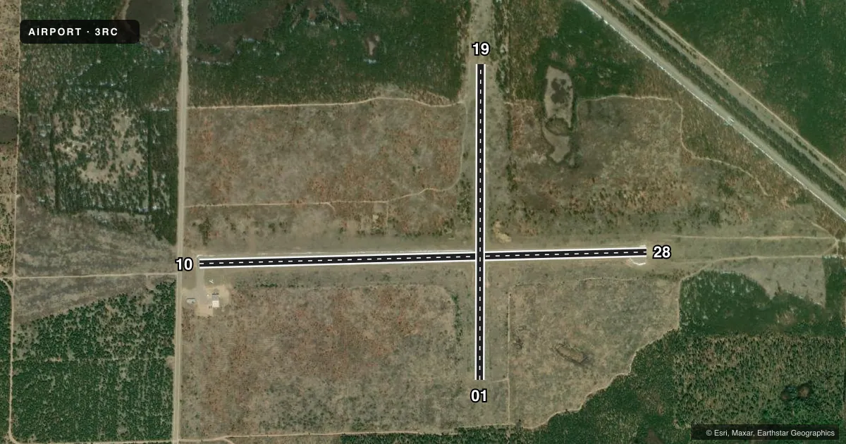
Airport sketch
Runways drawn to scale from FAA survey coordinates, rendered over satellite imagery. Not for navigation.
Approaches & charts
Services on the field
Fuel grades, oxygen, maintenance, ramp storage and lighting — as declared to the FAA by the airport operator.
Fuel & services
- Fuel
- Not available
Ramp & ground
- Transient storage
- Tie-down
- Landing fee
- No fee published
- Lighting schedule
- SEE RMK
- Wind indicator
- Lighted
- Segmented circle
- No
Fuel & FBOs
Cheapest 100LL and Jet A on the field and nearby. Always confirm with the FBO before taxi.
Airport notes
Surface conditions, obstructions, local procedures, lighting outages and other notes published with each FAA cycle.
General notes
- LRG BIRDS & LRG MAMMALS ON & INVOF ARPT.
- FOR CD CTC MINNEAPOLIS ARTCC AT 651-463-5588.
Lighting notes
- ACTVT LIRL RWY 10/28 - CTAF.
Runway surface & condition
- 01/19CLSD NOV-APR & WHEN SNOW COVD.
Approach & departure obstructions
- 1015 FT ROAD, 145 FT DIST; 25 FT TREES, 178 FT DIST; 4 FT FENCE, 85 FT DIST.
- 013 FT YELLOW CONES.
- 193 FT YELLOW CONES.
- 01APCH RATIO 8:1 TO DTHR OVR +10 FT TREE, 86 FT DIST, 80 FT L.
- 10APCH RATIO 20:1 TO DTHR.
- 19APCH RATIO 20:1 TO DTHR.
Other notes
- MANAGEREXTN 2051 FOR OFC.
- OWNEREXTN 2722053.
- 01/19SFC ROUGH WITH PATCHES OF GRVL.
VFR map & nearby airports
VFR sectional. Tap any ICAO chip to open that airport.
Key facts · 3RC
Answer card- ICAO
- 3RC
- Name
- ROSCOMMON CONSERVATION
- Location
- ROSCOMMON, MICHIGAN
- Elevation
- 1,157 ft MSL
- Traffic pattern altitude
- 2,157 ft MSL (1,000 AGL)
- Control tower
- Non-towered (use CTAF)
- Total runways
- 2
- Longest runway
- 10/28 · 3,552 ft
- Published ILS approaches
- 0
- Published frequencies
- 1
- Magnetic variation
- 5°
- Current flight rules
- VFR
- Current wind
- 270° at 9 kt
- Favored runway now
- RWY 28
Roscommon Conservation Airport is in Roscommon, Michigan. Field elevation is 1,157 ft MSL. The airport has two runways. The longest is 10/28 at 3,552 ft. Runway 01/19 is 2,500 ft turf. There is no control tower. CTAF is 122.9. No ILS approaches are published.
Pattern altitude is not published. Use the standard 1,000 ft AGL for light piston operations unless the current Chart Supplement says otherwise. That puts the traffic pattern at 2,157 ft MSL based on the field elevation here. Runway 10/28 has low intensity lights that are activated by CTAF. Runway 01/19 is closed November through April and when snow covered. It is also listed as rough with patches of gravel.
The published remarks matter here. Runway 10 has nearby obstacles near the threshold. Runway 19 has a displaced threshold note with a 20 to 1 approach slope. Large birds and large mammals are reported on and near the airport. There are no on-field FBOs listed, so verify fuel and services with the airport operator or the FBO directly by phone before you go. For clearance delivery, Minneapolis ARTCC is listed in the Chart Supplement. This is a non-towered field, so plan your self-announce calls carefully and expect local traffic on 122.9.