METAR & TAF 5M6
5M6 does not publish a METAR.
Showing the nearest reporting station: KGDW (GLADWIN ZETTEL MEML) · 10.3 NM away. Conditions at 5M6 may differ.
METAR · KGDW
Observed 22:15Z
KGDW 272215Z AUTO 27009KT 10SM FEW036 28/19 A2970 RMK AO2 LTG DSNT S
- Wind
- 270° @ 9 kt
- Visibility
- 10 SM
- Temp / Dew
- 28°C / 19°C
- Altimeter
- 29.70 inHg
- Clouds
- FEW
- Density alt
- 3,015 ft
- Ceiling
- Unlimited
- Rules
- VFR
Airport info & contacts
Manager on record, flight service, ARTCC, attendance schedule and pattern altitude — published by the FAA and refreshed every 28 days.
Location
- From city
- 10 NM N
- VFR sectional
- LAKE HURON
- ARTCC
- ZMP · MINNEAPOLIS
- NOTAM facility
- LAN (NOTAM-D)
Airport manager
- Name
- BRIAN HORTON
- Phone
- 989-359-0632
- Address
- 5477 WORTHINGTON CT, GLADWIN MI 48624-8120
Flight service · Hours
- FSS LAN
- LANSING1-800-WX-BRIEF
- Attendance
- Unattended
Frequencies
Tap any row to copy the frequency to your clipboard.
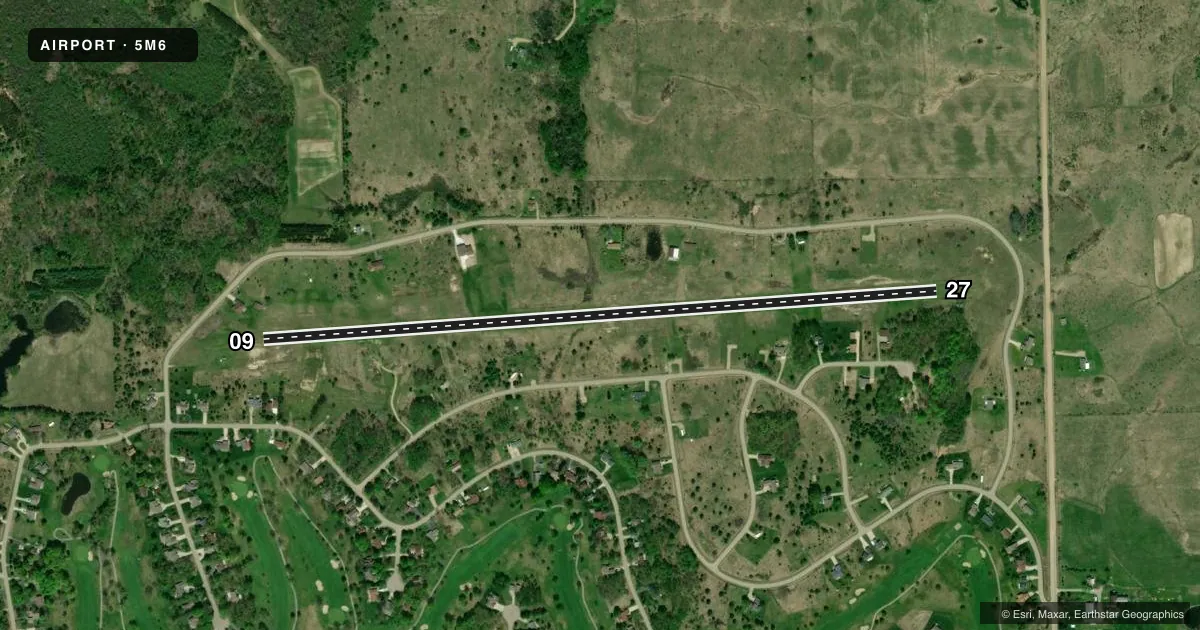
Runways & pattern
Full pagePattern entry · RWY 27
LEFT TRAFFICRunway end performance
| End | TORA | TODA | ASDA | LDA | VGSI | Approach lights | Obstruction |
|---|---|---|---|---|---|---|---|
| 09 | — | — | — | — | — | — | 11', tree, 126' from thr, 112' R of cntrln, slope 11 |
| 27 | — | — | — | — | — | — | 53', tree, 0' from thr, 125' R of cntrln, slope 1 |
Declared distances in feet. TORA = takeoff run available, TODA = takeoff distance, ASDA = accelerate-stop, LDA = landing distance.
Airport sketch
Runways drawn to scale from FAA survey coordinates, rendered over satellite imagery. Not for navigation.
Approaches & charts
Services on the field
Fuel grades, oxygen, maintenance, ramp storage and lighting — as declared to the FAA by the airport operator.
Fuel & services
- Fuel
- Not available
Ramp & ground
- Transient storage
- Not published
- Landing fee
- No fee published
- Wind indicator
- Yes
- Segmented circle
- No
Fuel & FBOs
Cheapest 100LL and Jet A on the field and nearby. Always confirm with the FBO before taxi.
Airport notes
Surface conditions, obstructions, local procedures, lighting outages and other notes published with each FAA cycle.
General notes
- FOR CD CTC MINNEAPOLIS ARTCC AT 651-463-5588.
- DEER & LRG BIRDS ON & INVOF ARPT.
- FQT ULTRALIGHT ACT MORNING/EVE.
Runway surface & condition
- 09/27CLSD WHEN SNOW COVD EXC FOR SKI EQUIPPED ACFT.
Approach & departure obstructions
- 093 FT YELLOW CONES.
- 273 FT YELLOW CONES.
Other notes
- PRVDD ANY ENVIROMENTAL ACTIONS BE RESOLVED BFR CONST & COMPLY WITH NEPA.
VFR map & nearby airports
VFR sectional. Tap any ICAO chip to open that airport.
Key facts · 5M6
Answer card- ICAO
- 5M6
- Name
- SUGAR SPRINGS AIRPARK
- Location
- GLADWIN, MICHIGAN
- Elevation
- 953 ft MSL
- Traffic pattern altitude
- 1,953 ft MSL (1,000 AGL)
- Control tower
- Non-towered (use CTAF)
- Total runways
- 1
- Longest runway
- 09/27 · 3,800 ft
- Published ILS approaches
- 0
- Published frequencies
- 1
- Magnetic variation
- 5°
- Current flight rules
- VFR
- Current wind
- 270° at 9 kt
- Favored runway now
- RWY 27
Sugar Springs Airpark is in Gladwin, Michigan. The field elevation is 953 ft MSL. It has one runway. Runway 09/27 is 3,800 ft of turf, with magnetic headings 86° and 266°. There is no control tower. CTAF is 122.9.
No ILS approaches are published here. Pattern altitude is not published in the facts, so verify the current Chart Supplement before you go. The published remarks also call out frequent ultralight activity in the morning and evening. Deer and large birds are reported on and near the airport, so keep a sharp scan on departure and in the pattern.
Runway 09/27 is closed when snow covered except for ski-equipped aircraft. Runway 09 has 3 ft yellow cones. Runway 27 has 3 ft yellow cones. For clearance delivery, contact Minneapolis ARTCC at 651-463-5588. There are no on-field FBOs listed in the facts, so plan to confirm services with the airport operator or the FBO directly by phone before arrival. This is a non-towered turf strip, so a good radio scan and traffic lookout matter more than usual.