METAR & TAF 48D
48D does not publish a METAR.
Showing the nearest reporting station: KMOP (MOUNT PLEASANT MUNI) · 12.8 NM away. Conditions at 48D may differ.
METAR · KMOP
Observed 15:55Z
KMOP 271555Z AUTO 24008G17KT 10SM CLR 30/19 A2976 RMK AO2 T03030186
- Wind
- 240° @ 8G17 kt
- Visibility
- 10 SM
- Temp / Dew
- 30°C / 19°C
- Altimeter
- 29.76 inHg
- Clouds
- CLR
- Density alt
- 3,060 ft
- Ceiling
- Unlimited
- Rules
- VFR
Airport info & contacts
Manager on record, flight service, ARTCC, attendance schedule and pattern altitude — published by the FAA and refreshed every 28 days.
Location
- From city
- 1 NM NE
- VFR sectional
- DETROIT
- ARTCC
- ZOB · CLEVELAND
- NOTAM facility
- LAN (NOTAM-D)
Airport manager
- Name
- GARY TODD
- Phone
- 989-386-0445
- Address
- 202 W 5TH ST, CLARE MI 48617-1490
Flight service · Hours
- FSS LAN
- LANSING1-800-WX-BRIEF
- Attendance
- IREG
Frequencies
Tap any row to copy the frequency to your clipboard.
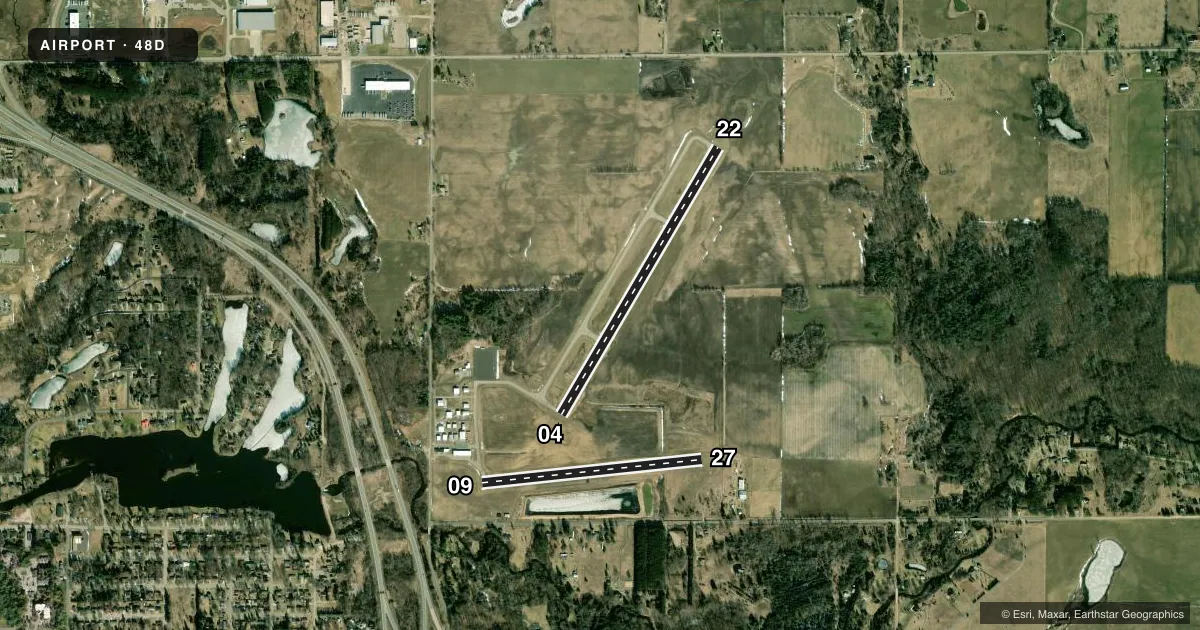
Runways & pattern
Full pagePattern entry · RWY 27
LEFT TRAFFIC| Runway | Heading (°M) | Length | Surface | Traffic |
|---|---|---|---|---|
| 04/22 | 25° / 205° | 3,500 ft | ASPH | Standard L |
| 09/27Favored | 79° / 259° | 2,499 ft | ASPH | Standard L |
Runway end performance
| End | TORA | TODA | ASDA | LDA | VGSI | Approach lights | Obstruction |
|---|---|---|---|---|---|---|---|
| 04 | — | — | — | — | PAPI 4-box left(4°) | — | — |
| 22 | — | — | — | — | PAPI 2-box left(3°) | — | — |
Declared distances in feet. TORA = takeoff run available, TODA = takeoff distance, ASDA = accelerate-stop, LDA = landing distance.
Airport sketch
Runways drawn to scale from FAA survey coordinates, rendered over satellite imagery. Not for navigation.
Approaches & charts
Services on the field
Fuel grades, oxygen, maintenance, ramp storage and lighting — as declared to the FAA by the airport operator.
Fuel & services
- Fuel
- 100LL
- Oxygen (bottled)
- Not available
- Oxygen (bulk)
- Not available
- Airframe repair
- Major
- Power plant repair
- Major
- Other services
- INSTR
Ramp & ground
- Transient storage
- Tie-down
- Hangar
- Landing fee
- No fee published
- Customs
- Not available
- Lighting schedule
- SEE RMK
- Beacon schedule
- SS-SR
- Beacon
- White / Green (civil land)(WG)
- Wind indicator
- Lighted
- Segmented circle
- Yes
Fuel & FBOs
Cheapest 100LL and Jet A on the field and nearby. Always confirm with the FBO before taxi.
Airport notes
Surface conditions, obstructions, local procedures, lighting outages and other notes published with each FAA cycle.
General notes
- DEER & LRG BIRDS ON & INVOF ARPT.
- ADMIN BLDG ACES: PRESS V, THEN III & II SIMUL, THEN I.
- FOR CD CTC GREAT LAKES APCH AT 269-459-3345, WHEN APCH CLSD CTC CLEVELAND ARTCC AT 440-774-0224/0490.
Lighting notes
- ACTVT REIL RWY 04 & 22; PAPI RWY 04 & 22; MIRL RWY 04/22 & 09/27 - CTAF.
Fuel notes
- 100LLFUEL AVBL H24 SELF SVC VIA CREDIT CARD.
Approach & departure obstructions
- 04FADED.
- 09FADED.
- 22FADED.
- 27FADED.
Other notes
- ESTABD BFR 1959.
- CALL AHD TO RES HNGR STORAGE.
- MANAGERCELL 989-802-2005.
VFR map & nearby airports
VFR sectional. Tap any ICAO chip to open that airport.
Key facts · 48D
Answer card- ICAO
- 48D
- Name
- CLARE MUNI
- Location
- CLARE, MICHIGAN
- Elevation
- 856 ft MSL
- Traffic pattern altitude
- 1,856 ft MSL (1,000 AGL)
- Control tower
- Non-towered (use CTAF)
- Total runways
- 2
- Longest runway
- 04/22 · 3,500 ft
- Published ILS approaches
- 0
- Published frequencies
- 4
- Magnetic variation
- 5°
- Current flight rules
- VFR
- Current wind
- 240° at 8 kt
- Favored runway now
- RWY 27
Clare Muni sits in Clare, Michigan. The field elevation is 856 ft MSL. It has two asphalt runways. The longest is 3,500 ft on runway 04/22. There is no control tower. Pattern altitude is not published. Use 1,000 ft AGL for light piston traffic unless the current Chart Supplement says otherwise.
No ILS approaches are published here. Runway lighting is pilot controlled on CTAF. Runway end identifier lights and PAPI are on runways 04 and 22. Medium intensity runway lights are on both runways. The published remarks also note faded markings on all runway ends, so give yourself extra time on the roll and on the turnoff. Deer and large birds are reported on and near the airport. That matters here more than most places.
Clare Municipal Airport is on the field. It carries 100LL. Self-serve fuel is available 24 hours a day by credit card. If you need hangar space, call ahead to reserve it. For first-time arrivals, expect a non-towered field with Great Lakes Approach handling clearance delivery when available. Check the current Chart Supplement for any noise or curfew restrictions before flying in. If you are coming in at night or in lower visibility, verify the lighting setup and the latest airport remarks before departure.