METAR & TAF KMBS
Current METAR
Observed 14:53Z
KMBS 271453Z 23014G20KT 10SM CLR 28/22 A2977 RMK AO2 SLP076 T02780222 56013
- Wind
- 230° @ 14G20 kt
- Visibility
- 10 SM
- Temp / Dew
- 28°C / 22°C
- Altimeter
- 29.77 inHg
- Clouds
- CLR
- Density alt
- 2,575 ft
- Ceiling
- Unlimited
- Rules
- VFR
Airport info & contacts
Manager on record, flight service, ARTCC, attendance schedule and pattern altitude — published by the FAA and refreshed every 28 days.
Location
- From city
- 9 NM NW
- VFR sectional
- DETROIT
- ARTCC
- ZOB · CLEVELAND
- NOTAM facility
- MBS (NOTAM-D)
Airport manager
- Name
- JAMES CANDERS
- Phone
- 989-695-5555
- Address
- 8500 GARFIELD RD STE 101, FREELAND MI 48623-8626
Flight service · Hours
- FSS LAN
- LANSING1-800-WX-BRIEF
- Attendance
- ALL
Frequencies
Tap any row to copy the frequency to your clipboard.
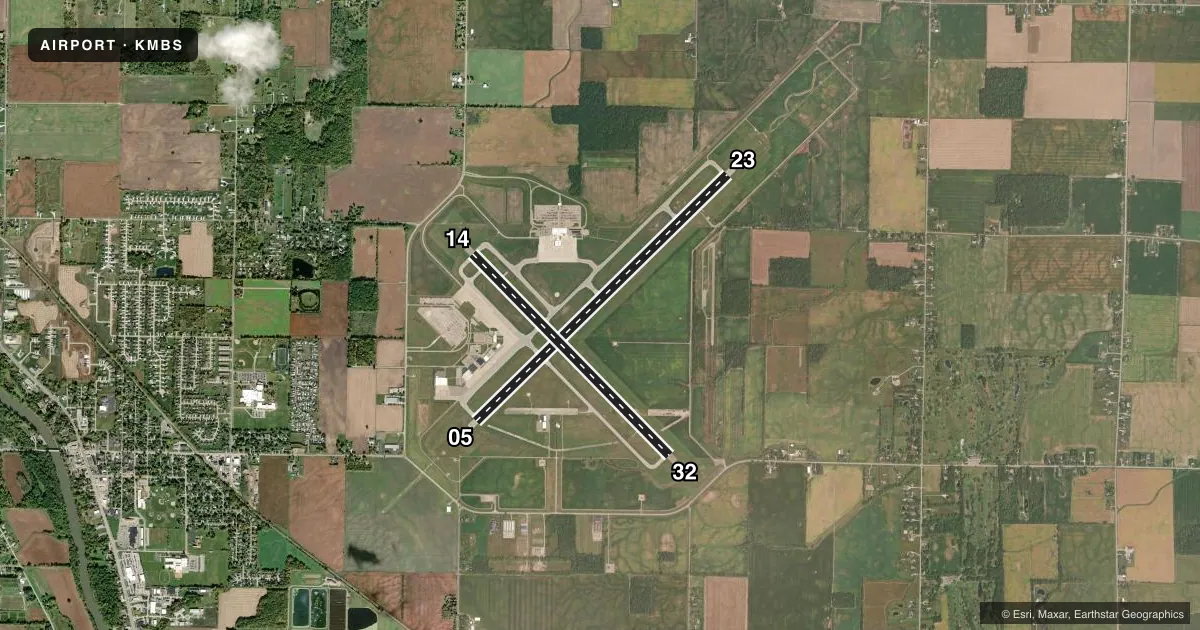
Runways & pattern
Full pagePattern entry · RWY 23
LEFT TRAFFIC| Runway | Heading (°M) | Length | Surface | Traffic |
|---|---|---|---|---|
| 05/23Favored | 39° / 219° | 8,002 ft | ASPH | Standard L |
| 14/32 | 129° / 309° | 6,400 ft | ASPH | Standard L |
Runway end performance
| End | TORA | TODA | ASDA | LDA | VGSI | Approach lights | Obstruction |
|---|---|---|---|---|---|---|---|
| 05 | 8,002' | 8,002' | 8,002' | 8,002' | — | MALSR | — |
| 23 | 8,002' | 8,002' | 8,002' | 8,002' | PAPI 4-box left(3°) | MALSR | — |
| 14 | 6,400' | 6,400' | 6,400' | 6,400' | PAPI 4-box left(3°) | — | 55', trees, 2300' from thr, 100' R of cntrln, slope 38 |
| 32 | 6,400' | 6,400' | 6,400' | 6,400' | PAPI 4-box left(3°) | — | 56', trees, 2500' from thr, 120' R of cntrln, slope 41 |
Declared distances in feet. TORA = takeoff run available, TODA = takeoff distance, ASDA = accelerate-stop, LDA = landing distance.
Airport sketch
Runways drawn to scale from FAA survey coordinates, rendered over satellite imagery. Not for navigation.
Approaches & charts
ILS · 2
Services on the field
Fuel grades, oxygen, maintenance, ramp storage and lighting — as declared to the FAA by the airport operator.
Fuel & services
- Fuel
- 100LLA
- Oxygen (bottled)
- High pressure
- Airframe repair
- Minor
- Power plant repair
- Minor
Ramp & ground
- Transient storage
- Tie-down
- Hangar
- Landing fee
- Yes
- Customs
- Not available
- Lighting schedule
- SEE RMK
- Beacon schedule
- SS-SR
- Beacon
- White / Green (civil land)(WG)
- Wind indicator
- Lighted
- Segmented circle
- Yes
Fuel & FBOs
Cheapest 100LL and Jet A on the field and nearby. Always confirm with the FBO before taxi.
Airport notes
Surface conditions, obstructions, local procedures, lighting outages and other notes published with each FAA cycle.
General notes
- BIRDS ON & INVOF ARPT.
- FOR CD WHEN ATCT CLSD CTC GREAT LAKES APCH AT 269-459-3345, WHEN APCH CLSD CTC CLEVELAND ARTCC AT 440-774-0224/0490.
Lighting notes
- WHEN ATCT CLSD ACTVT MALSR RWY 05 & 23; REIL RWY 14 & 32; HIRL RWY 05/23 & 14/32 - CTAF. PAPI RWY 14, 23, & 32 OPR CONSLY.
Runway surface & condition
- 05/23PCR VALUE: 545/F/B/X/T
- 14/32PCR VALUE: 545/F/B/X/T
Other notes
- INDEX C ARFF SVC AVBL UPON REQ.
- WAIVED WITH FUEL PURCHASE.
- 1FOR SVC AFT HRS CALL 800-227-7907.
- MANAGERAFT BUS HRS CALL 989-695-5558.
VFR map & nearby airports
VFR sectional. Tap any ICAO chip to open that airport.
Key facts · KMBS
Answer card- ICAO
- KMBS
- Name
- MBS INTL
- Location
- SAGINAW, MICHIGAN
- Elevation
- 668.3 ft MSL
- Traffic pattern altitude
- 1,668.3 ft MSL (1,000 AGL)
- Control tower
- Towered · 0600-2300
- Total runways
- 2
- Longest runway
- 05/23 · 8,002 ft
- Published ILS approaches
- 2
- Published frequencies
- 11
- Magnetic variation
- 7°
- Current flight rules
- VFR
- Current wind
- 230° at 14 kt
- Favored runway now
- RWY 23
MBS Intl sits in Saginaw, Michigan. The field elevation is 668.3 ft MSL. It has 2 asphalt runways. The longest is 8,002 ft on 05/23. The other runway is 14/32 at 6,400 ft. The tower is open 0600-2300. Two ILS approaches are published for runway ends 05 and 23.
Pattern altitude is not published in the facts, so use the standard 1,000 ft AGL for light piston traffic unless ATC or the current Chart Supplement says otherwise. Avflight Saginaw is on the field. It carries 100LL, Jet A and Jet A Prist. For after-hours service, the published remarks say to call 800-227-7907. Landing fees are waived with fuel purchase.
This is a towered field with Great Lakes Approach handling clearance delivery when the tower is closed. Birds are reported on and near the airport, so keep a sharp scan on departure and in the pattern. Runway lighting and approach lighting can be activated on CTAF when the tower is closed. The airport also notes that the PAPI for 14, 23 and 32 operates continuously. Check the current Chart Supplement for any updated procedures before you go.