METAR & TAF KHYX
Current METAR
Observed 19:35Z
KHYX 271935Z AUTO 24010KT 10SM CLR 28/18 A2973 RMK AO2 PRESFR
- Wind
- 240° @ 10 kt
- Visibility
- 10 SM
- Temp / Dew
- 28°C / 18°C
- Altimeter
- 29.73 inHg
- Clouds
- CLR
- Density alt
- 2,541 ft
- Ceiling
- Unlimited
- Rules
- VFR
Airport info & contacts
Manager on record, flight service, ARTCC, attendance schedule and pattern altitude — published by the FAA and refreshed every 28 days.
Location
- From city
- 4 NM E
- VFR sectional
- DETROIT
- ARTCC
- ZOB · CLEVELAND
- NOTAM facility
- HYX (NOTAM-D)
Airport manager
- Name
- ALAN KAUFMAN
- Phone
- 989-295-0675
- Address
- 4789 JANES RD, SAGINAW MI 48601
Flight service · Hours
- FSS LAN
- LANSING1-800-WX-BRIEF
- Attendance
- MON-FRI · 0730-1700
- SAT-SUN · 0800-1200
Frequencies
Tap any row to copy the frequency to your clipboard.
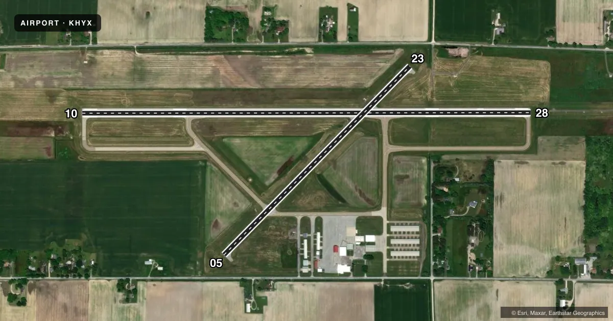
Runways & pattern
Full pagePattern entry · RWY 23
LEFT TRAFFIC| Runway | Heading (°M) | Length | Surface | Traffic |
|---|---|---|---|---|
| 10/28 | 83° / 263° | 5,002 ft | ASPH | Standard L |
| 05/23Favored | 38° / 218° | 2,952 ft | ASPH | Standard L |
Runway end performance
| End | TORA | TODA | ASDA | LDA | VGSI | Approach lights | Obstruction |
|---|---|---|---|---|---|---|---|
| 10 | — | — | — | — | PAPI 4-box left(3°) | — | 4', brush, 229' from thr, 313' R of cntrln, slope 7 |
| 28 | — | — | — | — | PAPI 4-box left(3°) | MALSF | 66', trees, 842' from thr, 620' R of cntrln, slope 9 |
| 05 | — | — | — | — | PAPI 2-box left(3°) | — | 6', fence, 200' from thr, 120' R of cntrln, slope 1 |
| 23 | — | — | — | — | PAPI 2-box right(3°) | — | 15', road, 210' from thr, 126' R of cntrln, slope 1 |
Declared distances in feet. TORA = takeoff run available, TODA = takeoff distance, ASDA = accelerate-stop, LDA = landing distance.
Airport sketch
Runways drawn to scale from FAA survey coordinates, rendered over satellite imagery. Not for navigation.
Approaches & charts
ILS · 1
Services on the field
Fuel grades, oxygen, maintenance, ramp storage and lighting — as declared to the FAA by the airport operator.
Fuel & services
- Fuel
- 100LLA+
- Airframe repair
- Major
- Power plant repair
- Major
- Other services
- INSTR,RNTL
Ramp & ground
- Transient storage
- Tie-down
- Landing fee
- No fee published
- Customs
- Not available
- Lighting schedule
- SEE RMK
- Beacon schedule
- SS-SR
- Beacon
- White / Green (civil land)(WG)
- Wind indicator
- Lighted
- Segmented circle
- No
Fuel & FBOs
Cheapest 100LL and Jet A on the field and nearby. Always confirm with the FBO before taxi.
Airport notes
Surface conditions, obstructions, local procedures, lighting outages and other notes published with each FAA cycle.
General notes
- DEER & LRG BIRDS ON & INVOF ARPT.
- FOR CD CTC GREAT LAKES APCH AT 269-459-3345, WHEN APCH CLSD CTC CLEVELAND ARTCC AT 440-774-0224/0490.
Lighting notes
- ACTVT MALSF RWY 28; REIL RWY 10; PAPI RWY 05, 23, 10, & 28; HIRL RWY 10/28; MIRL RWY 05/23 - CTAF. PAPI RWY 10 & 28 OPR CONSLY DURG DALGT HRS.
Fuel notes
- 100LL100LL & JET A+ AVBL H24 SELF SVC.
Approach & departure obstructions
- 232 FT CONC CULVERT, 100 FT DIST, 80 FT L; -15 FT DITCH, ACRS APCH END.
- 05APCH RATIO 20:1 TO DTHR.
- 23APCH RATIO 20:1 TO DTHR.
Other notes
- 1UNATNDD MAJOR HOLS.
VFR map & nearby airports
VFR sectional. Tap any ICAO chip to open that airport.
Key facts · KHYX
Answer card- ICAO
- KHYX
- Name
- SAGINAW COUNTY/H W BROWNE
- Location
- SAGINAW, MICHIGAN
- Elevation
- 601.5 ft MSL
- Traffic pattern altitude
- 1,601.5 ft MSL (1,000 AGL)
- Control tower
- Non-towered (use CTAF)
- Total runways
- 2
- Longest runway
- 10/28 · 5,002 ft
- Published ILS approaches
- 1
- Published frequencies
- 4
- Magnetic variation
- 7°
- Current flight rules
- VFR
- Current wind
- 240° at 10 kt
- Favored runway now
- RWY 23
Saginaw County/H W Browne sits in Saginaw, Michigan. Field elevation is 601.5 ft MSL. The airport has two asphalt runways. The longest is 10/28 at 5,002 ft. This is a non-towered field. Pattern altitude is not published, so use the standard 1,000 ft AGL for light piston traffic unless the current Chart Supplement says otherwise.
Runway 28 has the published ILS. Runway 28 also has MALSR lighting. Runway 10 has REIL. PAPI is published on both ends of 10/28 and on both ends of 05/23. HIRL is on 10/28. MIRL is on 05/23 and is controlled by CTAF. Great Lakes Approach handles clearance delivery. When approach is closed, Cleveland ARTCC is the backup contact listed in the remarks.
Harry W. Browne Airport is on the field. It carries 100LL and Jet A+. Self-serve fuel is available 24 hours a day. That helps for late arrivals. Watch runway 23 closely. The published remarks call out a culvert near the end of the runway and a ditch across the approach end. Deer and large birds are also reported on and near the airport. Major holidays can mean the airport is unattended, so plan ahead if you need local help.