METAR & TAF 51G
51G does not publish a METAR.
Showing the nearest reporting station: KFNT (BISHOP INTL) · 10.9 NM away. Conditions at 51G may differ.
METAR · KFNT
Observed 15:32Z
KFNT 271532Z 25011G21KT 10SM SCT026 29/22 A2979 RMK AO2 T02940217
- Wind
- 250° @ 11G21 kt
- Visibility
- 10 SM
- Temp / Dew
- 29°C / 22°C
- Altimeter
- 29.79 inHg
- Clouds
- SCT
- Density alt
- 2,727 ft
- Ceiling
- Unlimited
- Rules
- VFR
Airport info & contacts
Manager on record, flight service, ARTCC, attendance schedule and pattern altitude — published by the FAA and refreshed every 28 days.
Location
- From city
- 3 NM SW
- VFR sectional
- DETROIT
- ARTCC
- ZOB · CLEVELAND
- NOTAM facility
- LAN (NOTAM-D)
Airport manager
- Name
- DOUGLAS SMITH
- Phone
- 810-444-7196
- Address
- 9419 N WEBSTER RD, CLIO MI 48420-8546
Flight service · Hours
- FSS LAN
- LANSING1-800-WX-BRIEF
- Attendance
- IREG
Frequencies
Tap any row to copy the frequency to your clipboard.
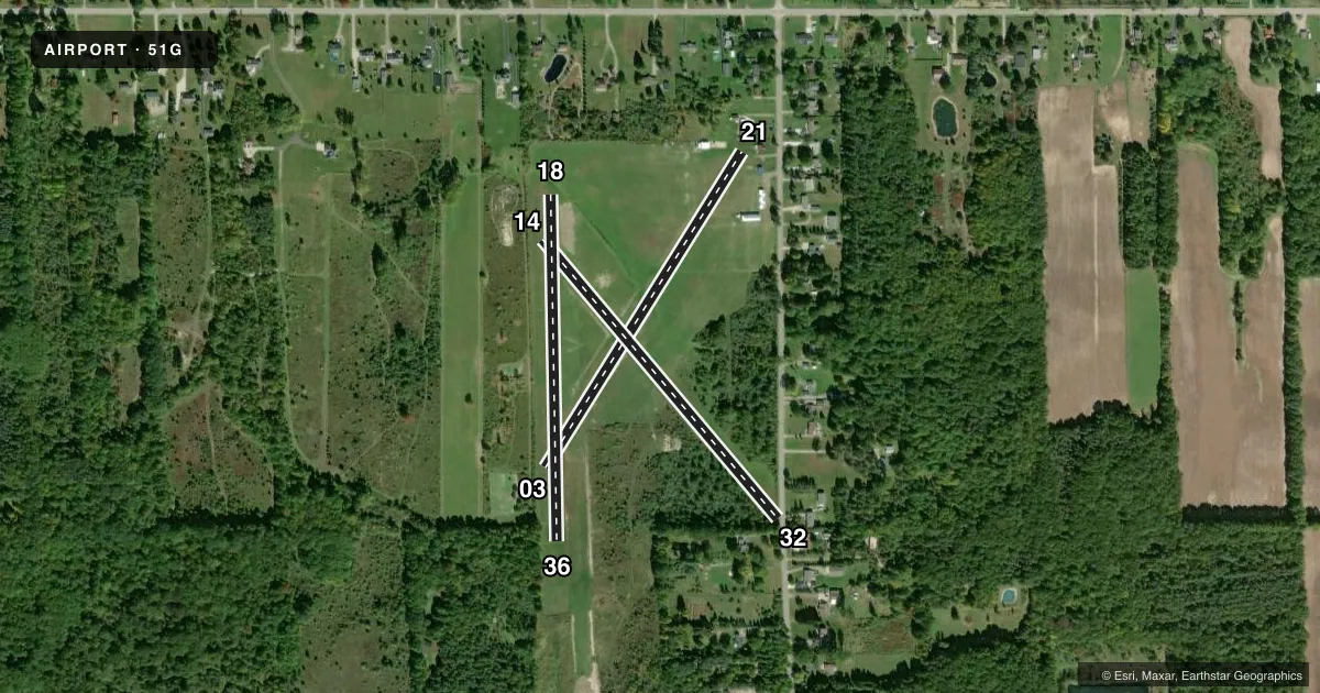
Runways & pattern
Full pagePattern entry · RWY 21
LEFT TRAFFIC| Runway | Heading (°M) | Length | Surface | Traffic |
|---|---|---|---|---|
| 03/21Favored | 26° / 206° | 1,933 ft | TURF | Standard L |
| 14/32 | 134° / 314° | 1,895 ft | TURF | Standard L |
| 18/36 | 173° / 353° | 1,800 ft | TURF | Standard L |
Runway end performance
| End | TORA | TODA | ASDA | LDA | VGSI | Approach lights | Obstruction |
|---|---|---|---|---|---|---|---|
| 03 | — | — | — | — | — | — | 70', tree, 600' from thr, 0' R of cntrln, slope 8 |
| 21 | — | — | — | — | — | — | 20', bldg, 70' from thr, 50' R of cntrln, slope 0 |
| 14 | — | — | — | — | — | — | 85', trees, 609' from thr, 93' R of cntrln, slope 7 |
| 32 | — | — | — | — | — | — | 76', trees, 0' from thr, 53' R of cntrln, slope 0 |
| 18 | — | — | — | — | — | — | 47', trees, 306' from thr, 100' R of cntrln, slope 6 |
| 36 | — | — | — | — | — | — | 68', trees, 0' from thr, 100' R of cntrln, slope 0 |
Declared distances in feet. TORA = takeoff run available, TODA = takeoff distance, ASDA = accelerate-stop, LDA = landing distance.
Airport sketch
Runways drawn to scale from FAA survey coordinates, rendered over satellite imagery. Not for navigation.
Approaches & charts
Services on the field
Fuel grades, oxygen, maintenance, ramp storage and lighting — as declared to the FAA by the airport operator.
Fuel & services
- Fuel
- Not available
- Oxygen (bottled)
- Not available
- Oxygen (bulk)
- Not available
- Airframe repair
- Not available
- Power plant repair
- Not available
Ramp & ground
- Transient storage
- Tie-down
- Landing fee
- No fee published
- Customs
- Not available
- Wind indicator
- Yes
- Segmented circle
- No
Fuel & FBOs
Cheapest 100LL and Jet A on the field and nearby. Always confirm with the FBO before taxi.
Airport notes
Surface conditions, obstructions, local procedures, lighting outages and other notes published with each FAA cycle.
General notes
- DEER, WILDLIFE, & LRG BIRDS ON & INVOF ARPT.
- FOR CD CTC GREAT LAKES APCH AT 269-459-3345, WHEN APCH CLSD CTC CLEVELAND ARTCC AT 440-774-0224/0490.
- CK NOTAMS FOR FICONS DURG WINTER MONTHS. RWYS CLSD DURG SNOW/WINTER OPS - NO SNOW REMOVAL.
Approach & departure obstructions
- 183 FT YELLOW CONES.
- 363 FT YELLOW CONES.
- 03+70 FT TREES, 600 FT DIST, 0 FT B.
- 14CTLG OBSTN EXCEEDS A 45 DEG SLP.
- 18+47 FT TREE, 306 FT DIST, 100 FT R.
- 36CTLG OBSTN EXCEEDS A 45 DEG SLP. +68 FT TREE, 0 FT DIST, 100 FT L.
Other notes
- ESTABD BFR 1959.
- 14/32ROUGH; AER 32 WET IN SPRING AFT RAIN.
VFR map & nearby airports
VFR sectional. Tap any ICAO chip to open that airport.
Key facts · 51G
Answer card- ICAO
- 51G
- Name
- ALKAY
- Location
- CLIO, MICHIGAN
- Elevation
- 714 ft MSL
- Traffic pattern altitude
- 1,714 ft MSL (1,000 AGL)
- Control tower
- Non-towered (use CTAF)
- Total runways
- 3
- Longest runway
- 03/21 · 1,933 ft
- Published ILS approaches
- 0
- Published frequencies
- 1
- Magnetic variation
- 6°
- Current flight rules
- VFR
- Current wind
- 250° at 11 kt
- Favored runway now
- RWY 21
ALKAY (51G) is in Clio, Michigan. The field elevation is 714 ft MSL. It has three turf runways. The longest is runway 03/21 at 1,933 ft. There is no control tower, so use CTAF 122.9 and keep your scan tight in the pattern.
No ILS approaches are published here. The pattern altitude is not published, so use the standard 1,000 ft AGL for light piston operations unless the current Chart Supplement says otherwise. Runways 03/21 and 14/32 are for local use only. They are not state licensed. Runway 03/21 is irregular and defined by mowing. It is also reported as rough. Runway 18 end and runway 36 end are marked with 3 foot yellow cones.
There are no on-field FBOs listed. Check with the airport operator or the FBO directly by phone before arrival if you need current services. Published remarks also note deer and large birds in the area. Winter operations need extra care because there is no snow removal. If you need clearance delivery, contact Great Lakes Approach. If approach is closed, contact Cleveland ARTCC.