METAR & TAF KRNP
Current METAR
Observed 21:35Z
KRNP 132135Z AUTO 21016G21KT 10SM CLR 28/08 A2982 RMK AO2 T02820081
- Wind
- 210° @ 16G21 kt
- Visibility
- 10 SM
- Temp / Dew
- 28°C / 8°C
- Altimeter
- 29.82 inHg
- Clouds
- CLR
- Density alt
- 2,598 ft
- Ceiling
- Unlimited
- Rules
- VFR
Airport info & contacts
Manager on record, flight service, ARTCC, attendance schedule and pattern altitude — published by the FAA and refreshed every 28 days.
Location
- From city
- 2 NM E
- VFR sectional
- DETROIT
- ARTCC
- ZOB · CLEVELAND
- NOTAM facility
- RNP (NOTAM-D)
Airport manager
- Name
- GARRY CSAPOS
- Phone
- 989-725-1969
- Address
- 205 AIRPORT DR, OWOSSO MI 48867-9153
Flight service · Hours
- FSS LAN
- LANSING1-800-WX-BRIEF
- Attendance
- MON-FRI · 0900-1700
- SAT-SUN · PRIOR ARNGMT
Frequencies
Tap any row to copy the frequency to your clipboard.
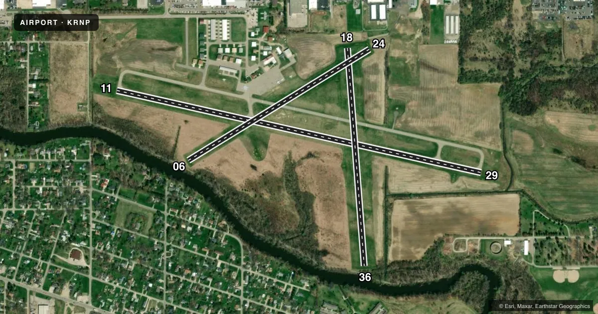
Runways & pattern
Full pagePattern entry · RWY 24
LEFT TRAFFIC| Runway | Heading (°M) | Length | Surface | Traffic |
|---|---|---|---|---|
| 11/29 | 97° / 277° | 4,300 ft | ASPH | Standard L |
| 18/36 | 170° / 350° | 2,509 ft | TURF | Standard L |
| 06/24Favored | 53° / 233° | 2,446 ft | TURF | Standard L |
Runway end performance
| End | TORA | TODA | ASDA | LDA | VGSI | Approach lights | Obstruction |
|---|---|---|---|---|---|---|---|
| 11 | — | — | — | — | PAPI 4-box left(3°) | — | 13', road, 272' from thr, 463' R of cntrln, slope 5 |
| 29 | — | — | — | — | PAPI 4-box right(3°) | — | 4', brush, 200' from thr, 155' R of cntrln, slope 0 |
| 18 | — | — | — | — | — | — | 34', tree, 154' from thr, 155' R of cntrln, slope 4 |
| 36 | — | — | — | — | — | — | 51', tree, 17' from thr, 0' R of cntrln, slope 0 |
| 06 | — | — | — | — | — | — | 35', tree, 0' from thr, 125' R of cntrln, slope 0 |
| 24 | — | — | — | — | — | — | 11', fence, 154' from thr, 145' R of cntrln, slope 14 |
Declared distances in feet. TORA = takeoff run available, TODA = takeoff distance, ASDA = accelerate-stop, LDA = landing distance.
Airport sketch
Runways drawn to scale from FAA survey coordinates, rendered over satellite imagery. Not for navigation.
Approaches & charts
Services on the field
Fuel grades, oxygen, maintenance, ramp storage and lighting — as declared to the FAA by the airport operator.
Fuel & services
- Fuel
- 100LL
- Oxygen (bottled)
- Not available
- Oxygen (bulk)
- Not available
- Airframe repair
- Major
- Power plant repair
- Major
- Other services
- INSTR,RNTL,SALES
Ramp & ground
- Transient storage
- Tie-down
- Hangar
- Landing fee
- No fee published
- Customs
- Not available
- Lighting schedule
- SEE RMK
- Beacon schedule
- SS-SR
- Beacon
- White / Green (civil land)(WG)
- Wind indicator
- Lighted
- Segmented circle
- Yes
Fuel & FBOs
Cheapest 100LL and Jet A on the field and nearby. Always confirm with the FBO before taxi.
Airport notes
Surface conditions, obstructions, local procedures, lighting outages and other notes published with each FAA cycle.
General notes
- DEER & LRG BIRDS ON & INVOF ARPT.
- FOR CD CTC GREAT LAKES APCH AT 269-459-3345, WHEN APCH CLSD CTC CLEVELAND ARTCC AT 440-774-0224/0490.
Lighting notes
- ACTVT REIL RWY 11 & 29; PAPI RWY 11 & 29; MIRL RWY 11/29 - CTAF. PAPI RWY 11 & 29 OPR CONSLY SR-SS.
Runway surface & condition
- 06/24CLSD DEC 1 THRU MAR 31 & WHEN SNOW COVD.
- 18/36CLSD DEC 1 THRU MAR 31 & WHEN SNOW COVD.
Approach & departure obstructions
- 06RWY & DTHR MKD WITH 3 FT YELLOW CONES.
- 18RWY & DTHR MKD WITH 3 FT YELLOW CONES.
- 243 FT YELLOW CONES.
- 36RWY & DTHR MKD WITH 3 FT YELLOW CONES.
- 11PAPI UNUSBL BYD 4 DEGS LEFT OF CNTRLN.
- 06CTLG OBSTN EXCEEDS A 45 DEG SLP. APCH RATIO 20:1 TO DTHR.
- 11CTLG OBSTN EXCEEDS A 45 DEG SLP.
- 18APCH RATIO 19:1 TO DTHR OVR +37 FT TREE, 724 FT DIST, 20 FT L.
- 36CTLG OBSTN EXCEEDS A 45 DEG SLP. APCH RATIO 19:1 TO DTHR OVR +75 FT TREES, 1467 FT DIST, 0 FT B.
Other notes
- FOR SVC CALL 989-413-7824.
- 18/36ROLLING TRRN; OPPOSITE APCH END NOT VSB.
VFR map & nearby airports
VFR sectional. Tap any ICAO chip to open that airport.
Key facts · KRNP
Answer card- ICAO
- KRNP
- Name
- OWOSSO COMMUNITY
- Location
- OWOSSO, MICHIGAN
- Elevation
- 736.7 ft MSL
- Traffic pattern altitude
- 1,736.7 ft MSL (1,000 AGL)
- Control tower
- Non-towered (use CTAF)
- Total runways
- 3
- Longest runway
- 11/29 · 4,300 ft
- Published ILS approaches
- 0
- Published frequencies
- 4
- Magnetic variation
- 6°
- Current flight rules
- VFR
- Current wind
- 210° at 16 kt
- Favored runway now
- RWY 24
Owosso Community Airport sits in Owosso, Michigan. Field elevation is 736.7 ft MSL. The airport has three runways. The longest is runway 11/29 at 4,300 ft asphalt. There is no control tower. No ILS approaches are published. Pattern altitude is not published, so use the standard 1,000 ft AGL for light piston traffic unless the current FAA Chart Supplement says otherwise.
The on-field FBO is Owosso Community Airport. It carries 100LL. For service, the published number is (989) 725-1969. The airport also lists a service number of 989-413-7824 in the remarks. Runway 11/29 has medium intensity lights. The lights are controlled by CTAF. REILs are installed on 11 and 29. PAPI is installed on 11 and 29. The PAPI works continuously from sunrise to sunset. That makes 11/29 the runway to study if you are arriving after dark or in marginal VFR.
A few runway notes matter here. Runway 06/24 is closed December 1 through March 31 and when snow covered. Runway 06 has cones marking the runway and displaced threshold. Runway 36 also has cones at the runway and displaced threshold. Runway 18/36 has rolling terrain. The opposite end is not visible from 18. Deer and large birds are present on and near the field. This is a non-towered airport with Great Lakes approach and departure frequencies available, so have the current radio plan ready before you call inbound.