METAR & TAF C57
C57 does not publish a METAR.
Showing the nearest reporting station: KRNP (OWOSSO COMMUNITY) · 11.1 NM away. Conditions at C57 may differ.
METAR · KRNP
Observed 13:35Z
KRNP 271335Z AUTO 23007KT 8SM BKN010 27/23 A2980 RMK AO2
- Wind
- 230° @ 7 kt
- Visibility
- 8 SM
- Temp / Dew
- 27°C / 23°C
- Altimeter
- 29.80 inHg
- Clouds
- BKN
- Density alt
- 2,527 ft
- Ceiling
- 1,000 ft AGL
- Rules
- MVFR
Airport info & contacts
Manager on record, flight service, ARTCC, attendance schedule and pattern altitude — published by the FAA and refreshed every 28 days.
Location
- From city
- 2 NM E
- VFR sectional
- DETROIT
- ARTCC
- ZOB · CLEVELAND
- NOTAM facility
- LAN (NOTAM-D)
Airport manager
- Name
- SCOTT MILLER
- Phone
- 517-204-2894
- Address
- 6757 N WARREN RD, ELSIE MI 48831-9404
Flight service · Hours
- FSS LAN
- LANSING1-800-WX-BRIEF
- Attendance
- Unattended
Frequencies
Tap any row to copy the frequency to your clipboard.
Runways & pattern
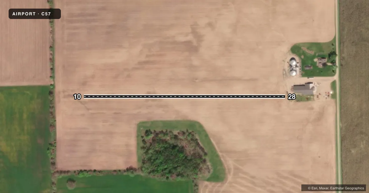
Full pagePattern entry · RWY 28
LEFT TRAFFICAirport sketch
Runways drawn to scale from FAA survey coordinates, rendered over satellite imagery. Not for navigation.
Approaches & charts
Services on the field
Fuel grades, oxygen, maintenance, ramp storage and lighting — as declared to the FAA by the airport operator.
Fuel & services
- Fuel
- Not available
Ramp & ground
- Transient storage
- Not published
Fuel & FBOs
Cheapest 100LL and Jet A on the field and nearby. Always confirm with the FBO before taxi.
Airport notes
Surface conditions, obstructions, local procedures, lighting outages and other notes published with each FAA cycle.
General notes
- FOR CD CTC GREAT LAKES APCH AT 269-459-3345, WHEN APCH CLSD CTC CLEVELAND ARTCC AT 440-774-0224/0490.
VFR map & nearby airports
VFR sectional. Tap any ICAO chip to open that airport.
Key facts · C57
Answer card- ICAO
- C57
- Name
- MILLERS LANDING
- Location
- ELSIE, MICHIGAN
- Elevation
- 757 ft MSL
- Traffic pattern altitude
- 1,757 ft MSL (1,000 AGL)
- Control tower
- Non-towered (use CTAF)
- Total runways
- 1
- Longest runway
- 10/28 · 1,875 ft
- Published ILS approaches
- 0
- Published frequencies
- 1
- Magnetic variation
- –
- Current flight rules
- MVFR
- Current wind
- 230° at 7 kt
- Favored runway now
- RWY 28
Millers Landing is in Elsie, Michigan. The field elevation is 757 ft MSL. It has one runway. Runway 10/28 is 1,875 ft of turf, so plan for soft-field technique and keep performance margins honest. No tower is published here. CTAF is 122.9. No ILS approaches are published.
The pattern altitude is not published. Use 1,000 ft AGL as the standard light-piston reference unless the current Chart Supplement says otherwise. For this field, that works out to about 1,757 ft MSL. There are no on-field FBOs listed. Check ahead for fuel or other services before you go. Published remarks say clearance delivery goes through Great Lakes Approach at 269-459-3345. If Approach is closed, contact Cleveland ARTCC at 440-774-0224 or 440-774-0490.
This is a small turf strip with no published ILS support. Weather and runway condition matter more than they would at a paved airport. Verify current runway condition, pattern notes and any local procedures in the current Chart Supplement before departure.