METAR & TAF 50G
50G does not publish a METAR.
Showing the nearest reporting station: KRNP (OWOSSO COMMUNITY) · 11.3 NM away. Conditions at 50G may differ.
METAR · KRNP
Observed 04:35Z
KRNP 140435Z AUTO 18004KT 10SM BKN065 22/15 A2979 RMK AO2 T02210145
- Wind
- 180° @ 4 kt
- Visibility
- 10 SM
- Temp / Dew
- 22°C / 15°C
- Altimeter
- 29.79 inHg
- Clouds
- BKN
- Density alt
- 1,796 ft
- Ceiling
- 6,500 ft AGL
- Rules
- VFR
Airport info & contacts
Manager on record, flight service, ARTCC, attendance schedule and pattern altitude — published by the FAA and refreshed every 28 days.
Location
- From city
- 1 NM W
- VFR sectional
- DETROIT
- ARTCC
- ZOB · CLEVELAND
- NOTAM facility
- LAN (NOTAM-D)
Airport manager
- Name
- RADFORD CHING
- Phone
- 517-974-8039
- Address
- 218 N FRONT ST, CHESANING MI 48616-1098
Flight service · Hours
- FSS LAN
- LANSING1-800-WX-BRIEF
- Attendance
- IREG
Frequencies
Tap any row to copy the frequency to your clipboard.
Runways & pattern
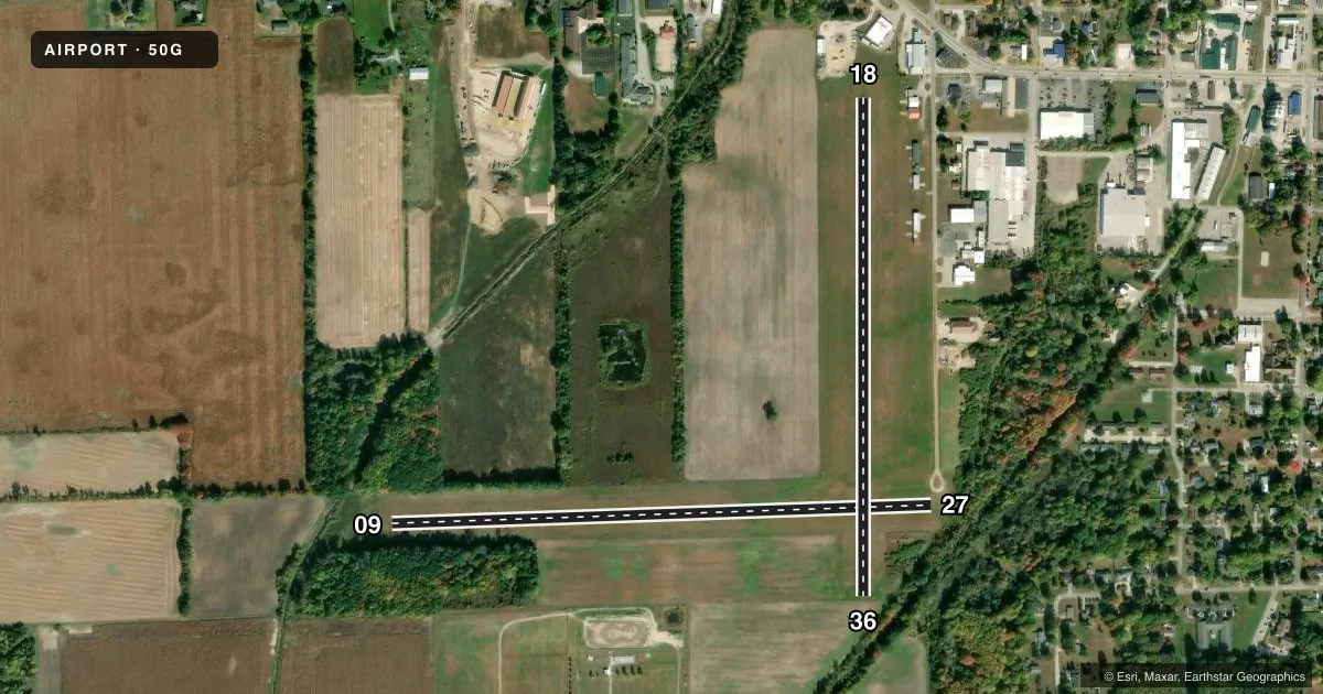
Full pagePattern entry · RWY 18
LEFT TRAFFIC| Runway | Heading (°M) | Length | Surface | Traffic |
|---|---|---|---|---|
| 09/27 | 83° / 263° | 2,800 ft | TURF | Standard L |
| 18/36Favored | 175° / 355° | 2,582 ft | TURF | Standard L |
Runway end performance
| End | TORA | TODA | ASDA | LDA | VGSI | Approach lights | Obstruction |
|---|---|---|---|---|---|---|---|
| 09 | — | — | — | — | — | — | 34', tree, 397' from thr, 40' R of cntrln, slope 11 |
| 27 | — | — | — | — | — | — | 15', road, 0' from thr, 90' R of cntrln, slope 0 |
| 18 | — | — | — | — | — | — | 75', tree, 411' from thr, 134' R of cntrln, slope 5 |
| 36 | — | — | — | — | — | — | 33', tree, 154' from thr, 132' R of cntrln, slope 4 |
Declared distances in feet. TORA = takeoff run available, TODA = takeoff distance, ASDA = accelerate-stop, LDA = landing distance.
Airport sketch
Runways drawn to scale from FAA survey coordinates, rendered over satellite imagery. Not for navigation.
Approaches & charts
Services on the field
Fuel grades, oxygen, maintenance, ramp storage and lighting — as declared to the FAA by the airport operator.
Fuel & services
- Fuel
- Not available
Ramp & ground
- Transient storage
- Tie-down
- Landing fee
- No fee published
- Customs
- Not available
- Lighting schedule
- SEE RMK
- Wind indicator
- Lighted
- Segmented circle
- No
Fuel & FBOs
Cheapest 100LL and Jet A on the field and nearby. Always confirm with the FBO before taxi.
Airport notes
Surface conditions, obstructions, local procedures, lighting outages and other notes published with each FAA cycle.
General notes
- NO WINTER SNOW REMOVAL.
- FOR CD CTC GREAT LAKES APCH AT 269-459-3345, WHEN APCH CLSD CTC CLEVELAND ARTCC AT 440-774-0224/0490.
- DEER & LRG BIRDS ON & INVOF ARPT.
Lighting notes
- ACTVT NSTD REIL RWY 09, 27, 18, & 36; NSTD LIRL RWY 09/27 & 18/36 - 5 CLICKS CTAF.
Runway surface & condition
- 09/27NSTD LIRL DUE TO COLOR.
- 18/36NSTD LIRL DUE TO COLOR.
Approach & departure obstructions
- 09NSTD REIL DUE TO LCTN.
- 18NSTD REIL DUE TO LCTN.
- 27NSTD REIL DUE TO LCTN.
- 36NSTD REIL DUE TO LCTN.
- 093 FT YELLOW CONES.
- 18RWY & DTHR MKD WITH 3 FT YELLOW CONES.
- 27RWY & DTHR MKD WITH 3 FT YELLOW CONES.
- 36RWY & DTHR MKD WITH 3 FT YELLOW CONES.
- 18APCH RATIO 20:1 TO DTHR.
- 27APCH RATIO 17:1 TO DTHR OVR +59 FT TREE, 1040 FT DIST, 90 FT R.
- 36APCH RATIO 18:1 TO DTHR OVR +63 FT TREE, 1166 FT DIST, 75 FT R.
- 180-8 FT SEASONAL CROPS, 22 FT DIST.
Other notes
- OWNERTROY FELTMAN, VILLAGE ADMINISTRATOR.
VFR map & nearby airports
VFR sectional. Tap any ICAO chip to open that airport.
Key facts · 50G
Answer card- ICAO
- 50G
- Name
- HOWARD NIXON MEML
- Location
- CHESANING, MICHIGAN
- Elevation
- 641 ft MSL
- Traffic pattern altitude
- 1,641 ft MSL (1,000 AGL)
- Control tower
- Non-towered (use CTAF)
- Total runways
- 2
- Longest runway
- 09/27 · 2,800 ft
- Published ILS approaches
- 0
- Published frequencies
- 1
- Magnetic variation
- 5°
- Current flight rules
- VFR
- Current wind
- 180° at 4 kt
- Favored runway now
- RWY 18
Howard Nixon Meml is in Chesaning, Michigan. Field elevation is 641 ft MSL. The airport has two turf runways. The longest is Runway 09/27 at 2,800 ft. There is no control tower. CTAF is 122.9. No ILS approaches are published. Pattern altitude is not published. Use 1,000 ft AGL for light piston operations unless the current Chart Supplement says otherwise.
This is a turf field with some operational notes that matter on arrival. Runway 18/36 has nonstandard low intensity runway lights due to color. Runway 09/27 also has nonstandard low intensity runway lights due to color. Runway 18 and Runway 27 have displaced threshold markings with 3 ft yellow cones. The published remarks also call out no winter snow removal. Deer and large birds are reported on and near the airport. Keep a sharp scan on the approach and rollout.
If you need clearance delivery, contact Great Lakes Approach at 269-459-3345. When approach is closed, contact Cleveland ARTCC at 440-774-0224 or 440-774-0490. There are no on-field FBOs listed. Verify services with the airport operator or call the field directly before you go. For a first visit, plan for turf performance, runway condition and the displaced threshold setup on 18 and 27. Check the current Chart Supplement for any additional local procedures before flying in.