METAR & TAF 3CM
3CM does not publish a METAR.
Showing the nearest reporting station: KHYX (SAGINAW COUNTY/H W BROWNE) · 7.0 NM away. Conditions at 3CM may differ.
METAR · KHYX
Observed 17:15Z
KHYX 121715Z AUTO 24012G18KT 10SM FEW036 23/14 A2984 RMK AO2
- Wind
- 240° @ 12G18 kt
- Visibility
- 10 SM
- Temp / Dew
- 23°C / 14°C
- Altimeter
- 29.84 inHg
- Clouds
- FEW
- Density alt
- 1,784 ft
- Ceiling
- Unlimited
- Rules
- VFR
Airport info & contacts
Manager on record, flight service, ARTCC, attendance schedule and pattern altitude — published by the FAA and refreshed every 28 days.
Location
- From city
- 3 NM S
- VFR sectional
- DETROIT
- ARTCC
- ZOB · CLEVELAND
- NOTAM facility
- LAN (NOTAM-D)
Airport manager
- Name
- BRYAN KING
- Phone
- 989-895-8991
- Address
- 614 S RIVER RD, BAY CITY MI 48708-9669
Flight service · Hours
- FSS LAN
- LANSING1-800-WX-BRIEF
- Attendance
- 0800-DUSK
Frequencies
Tap any row to copy the frequency to your clipboard.
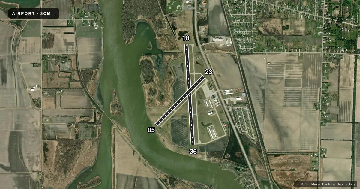
Runways & pattern
Full pagePattern entry · RWY 23
LEFT TRAFFIC| Runway | Heading (°M) | Length | Surface | Traffic |
|---|---|---|---|---|
| 18/36 | 169° / 349° | 3,798 ft | ASPH | Standard L |
| 05/23Favored | 38° / 218° | 2,599 ft | ASPH | Standard L |
Runway end performance
| End | TORA | TODA | ASDA | LDA | VGSI | Approach lights | Obstruction |
|---|---|---|---|---|---|---|---|
| 18 | — | — | — | — | PAPI 4-box left(4°) | — | 2', brush, 200' from thr, 192' R of cntrln, slope 0 |
| 36 | — | — | — | — | PAPI 4-box left(4°) | — | 8', gnd, 200' from thr, 250' R of cntrln, slope 0 |
| 23 | — | — | — | — | — | — | 19', road, 231' from thr, 125' R of cntrln, slope 1 |
Declared distances in feet. TORA = takeoff run available, TODA = takeoff distance, ASDA = accelerate-stop, LDA = landing distance.
Airport sketch
Runways drawn to scale from FAA survey coordinates, rendered over satellite imagery. Not for navigation.
Approaches & charts
Services on the field
Fuel grades, oxygen, maintenance, ramp storage and lighting — as declared to the FAA by the airport operator.
Fuel & services
- Fuel
- 100LL
- Oxygen (bottled)
- Not available
- Oxygen (bulk)
- Not available
- Airframe repair
- Not available
- Power plant repair
- Not available
Ramp & ground
- Transient storage
- Tie-down
- Hangar
- Landing fee
- No fee published
- Customs
- Not available
- Lighting schedule
- SEE RMK
- Beacon schedule
- SS-SR
- Beacon
- White / Green (civil land)(WG)
- Wind indicator
- Lighted
- Segmented circle
- Yes
Fuel & FBOs
Cheapest 100LL and Jet A on the field and nearby. Always confirm with the FBO before taxi.
Airport notes
Surface conditions, obstructions, local procedures, lighting outages and other notes published with each FAA cycle.
General notes
- OCNL SEAPLANE, AGRICULTURAL, AEROBATIC, & ULTRALIGHT ACT ON & INVOF ARPT.
- SHIP BUOYS IN RIVER CHANNEL.
- DEER, LRG BIRDS, & BALD EAGLE ACT ON & INVOF ARPT.
- RWY 05 & 36 OCNL +100 FT SHIPS XNG APCH SFCS DURG NAV SEASONS 600-800 FT FM THR.
- FOR CD CTC GREAT LAKES APCH AT 269-459-3345, WHEN APCH CLSD CTC CLEVELAND ARTCC AT 440-774-0224/0490.
Lighting notes
- ACTVT PAPI RWY 18 & 36; MIRL RWY 18/36 & 05/23 - CTAF.
Approach & departure obstructions
- 05+4 FT DIKE, 85 FT DIST.
- 36+15 FT BRUSH, 0 FT DIST, 250 FT L.
- 05APCH RATIO 20:1 AT DTHR.
- 18CTLNG OBSTN EXCEEDS 45 DEG SLP.
- 23APCH RATIO 20:1 AT DTHR.
- 36CTLNG OBSTN EXCEEDS 45 DEG SLP.
Other notes
- NOT IN COMPLIANCE WITH FAR 157; SPB ESTABD BFR 1959.
VFR map & nearby airports
VFR sectional. Tap any ICAO chip to open that airport.
Key facts · 3CM
Answer card- ICAO
- 3CM
- Name
- JAMES CLEMENTS MUNI
- Location
- BAY CITY, MICHIGAN
- Elevation
- 584.6 ft MSL
- Traffic pattern altitude
- 1,584.6 ft MSL (1,000 AGL)
- Control tower
- Non-towered (use CTAF)
- Total runways
- 2
- Longest runway
- 18/36 · 3,798 ft
- Published ILS approaches
- 0
- Published frequencies
- 4
- Magnetic variation
- 7°
- Current flight rules
- VFR
- Current wind
- 240° at 12 kt
- Favored runway now
- RWY 23
James Clements Muni sits in Bay City, Michigan. The field elevation is 584.6 ft MSL. It has two asphalt runways. The longest is 18/36 at 3,798 ft. There is no control tower, so use CTAF 122.725 for local traffic and monitor the field closely in the pattern.
No ILS approaches are published here. The pattern altitude is not published, so use the standard 1,000 ft AGL for light piston operations unless the current FAA Chart Supplement says otherwise. On the field, James Clements Municipal Airport carries AVGAS 100LL. Call (989) 895-8991 to confirm current services before you go.
The published remarks matter here. Runway 05 has a dike near the departure end. Runway 18 and runway 36 have obstacle notes that deserve attention on approach. Medium intensity runway lights are installed on both runways. The PAPI is active on 18 and 36. Great Lakes Approach handles clearance delivery. When Great Lakes is closed, Cleveland ARTCC is the backup contact. Expect mixed traffic too. The airport notes seaplanes, ag aircraft, aerobatic flights and ultralights in the area. Deer, large birds and bald eagles are also active around the field. That makes a good scan on final and during taxi.