METAR & TAF 77G
77G does not publish a METAR.
Showing the nearest reporting station: KCFS (TUSCOLA AREA) · 17.8 NM away. Conditions at 77G may differ.
METAR · KCFS
Observed 01:05Z
KCFS 280105Z AUTO 24002KT 10SM CLR 22/19 A2968 RMK AO2
- Wind
- 240° @ 2 kt
- Visibility
- 10 SM
- Temp / Dew
- 22°C / 19°C
- Altimeter
- 29.68 inHg
- Clouds
- CLR
- Density alt
- 2,247 ft
- Ceiling
- Unlimited
- Rules
- VFR
Airport info & contacts
Manager on record, flight service, ARTCC, attendance schedule and pattern altitude — published by the FAA and refreshed every 28 days.
Location
- From city
- 1 NM SW
- VFR sectional
- DETROIT
- ARTCC
- ZOB · CLEVELAND
- NOTAM facility
- LAN (NOTAM-D)
Airport manager
- Name
- PHIL ROACH
- Phone
- 810-459-4674
- Address
- 6725 AIRPORT RD, MARLETTE MI 48453-8210
Flight service · Hours
- FSS LAN
- LANSING1-800-WX-BRIEF
- Attendance
- Unattended
Frequencies
Tap any row to copy the frequency to your clipboard.
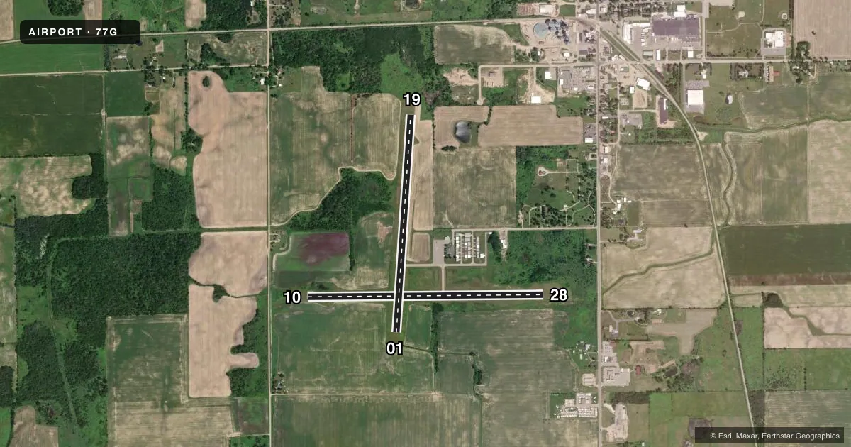
Runways & pattern
Full pagePattern entry · RWY 28
LEFT TRAFFIC| Runway | Heading (°M) | Length | Surface | Traffic |
|---|---|---|---|---|
| 10/28Favored | 81° / 261° | 3,795 ft | ASPH | Standard L |
| 01/19 | 356° / 176° | 3,500 ft | ASPH | Standard L |
Runway end performance
| End | TORA | TODA | ASDA | LDA | VGSI | Approach lights | Obstruction |
|---|---|---|---|---|---|---|---|
| 10 | — | — | — | — | PAPI 2-box right(3°) | — | 35', tree, 782' from thr, 324' R of cntrln, slope 16 |
| 28 | — | — | — | — | PAPI 2-box left(3°) | — | 17', tree, 200' from thr, 250' R of cntrln, slope 0 |
| 01 | — | — | — | — | PAPI 2-box left(3°) | — | — |
| 19 | — | — | — | — | PAPI 2-box left(3°) | — | 10', tree, 287' from thr, 250' R of cntrln, slope 8 |
Declared distances in feet. TORA = takeoff run available, TODA = takeoff distance, ASDA = accelerate-stop, LDA = landing distance.
Airport sketch
Runways drawn to scale from FAA survey coordinates, rendered over satellite imagery. Not for navigation.
Approaches & charts
Services on the field
Fuel grades, oxygen, maintenance, ramp storage and lighting — as declared to the FAA by the airport operator.
Fuel & services
- Fuel
- 100LL
Ramp & ground
- Transient storage
- Tie-down
- Hangar
- Landing fee
- No fee published
- Customs
- Not available
- Lighting schedule
- SEE RMK
- Beacon schedule
- SS-SR
- Beacon
- White / Green (civil land)(WG)
- Wind indicator
- Lighted
- Segmented circle
- Yes
Fuel & FBOs
Cheapest 100LL and Jet A on the field and nearby. Always confirm with the FBO before taxi.
Airport notes
Surface conditions, obstructions, local procedures, lighting outages and other notes published with each FAA cycle.
General notes
- FOR CD CTC CLEVELAND ARTCC AT 440-774-0224/0490.
- DEER & LRG BIRDS ON & INVOF ARPT.
- TRML BLDG ACES: 5-3-2-1*.
Lighting notes
- ACTVT PAPI RWY 01, 19, 10, & 28; MIRL RWY 01/19 & 10/28 - CTAF.
Fuel notes
- 100LLAVBL H24 SELF SVC VIA CREDIT CARD.
Approach & departure obstructions
- 10CTLG OBSTN EXCEEDS A 45 DEG SLP.
- 010-8 FT SEASONAL CROPS, 230 FT DIST, 120 FT R.
- 100-8 FT SEASONAL CROPS, 200 FT DIST, 96 FT R.
Other notes
- FOR TSNT STORAGE CALL AMGR.
VFR map & nearby airports
VFR sectional. Tap any ICAO chip to open that airport.
Key facts · 77G
Answer card- ICAO
- 77G
- Name
- MARLETTE TOWNSHIP
- Location
- MARLETTE, MICHIGAN
- Elevation
- 894.9 ft MSL
- Traffic pattern altitude
- 1,894.9 ft MSL (1,000 AGL)
- Control tower
- Non-towered (use CTAF)
- Total runways
- 2
- Longest runway
- 10/28 · 3,795 ft
- Published ILS approaches
- 0
- Published frequencies
- 2
- Magnetic variation
- 8°
- Current flight rules
- VFR
- Current wind
- 240° at 2 kt
- Favored runway now
- RWY 28
Marlette Township Airport (77G) sits in Marlette, Michigan. Field elevation is 894.9 ft MSL. The airport has two asphalt runways. The longest is 3,795 ft on runway 10/28. There is no control tower. CTAF and UNICOM are both 122.8. No ILS approaches are published here.
Pattern altitude is not published. Use the standard 1,000 ft AGL for light piston traffic unless the current FAA Chart Supplement says otherwise. That puts the pattern at about 1,895 ft MSL based on the field elevation, but verify before you fly. The on-field FBO is Marlette Township Airport. It carries 100LL. Self-serve 100LL is available 24 hours a day by credit card.
A few published remarks matter on arrival. Seasonal crops can sit close to the runway ends on 01 and 10. Obstacles near runway 10 also exceed a 45 degree slope. Deer and large birds are present on and near the airport. PAPI is active on all four runway ends. Medium intensity runway lights on 01/19 and 10/28 are controlled by CTAF. For clearance delivery, contact Cleveland ARTCC. If you need transient storage, call the airport manager. Terminal building access codes are published in the Chart Supplement. Check the current FAA Chart Supplement before departure for any updated field notes or local procedures.