METAR & TAF 4Y8
4Y8 does not publish a METAR.
Showing the nearest reporting station: KPHN (ST CLAIR COUNTY INTL) · 20.1 NM away. Conditions at 4Y8 may differ.
METAR · KPHN
Observed 16:35Z
KPHN 271635Z AUTO 21010G15KT 10SM SCT031 SCT037 30/22 A2977 RMK AO2
- Wind
- 210° @ 10G15 kt
- Visibility
- 10 SM
- Temp / Dew
- 30°C / 22°C
- Altimeter
- 29.77 inHg
- Clouds
- SCT
- Density alt
- 2,978 ft
- Ceiling
- Unlimited
- Rules
- VFR
Airport info & contacts
Manager on record, flight service, ARTCC, attendance schedule and pattern altitude — published by the FAA and refreshed every 28 days.
Location
- From city
- 5 NM NNE
- VFR sectional
- DETROIT
- ARTCC
- ZOB · CLEVELAND
- NOTAM facility
- LAN (NOTAM-D)
Airport manager
- Name
- JEFFERY P KOHLITZ
- Phone
- 313-320-2503
- Address
- 39748 CANNON DR, HARRISON TOWNSHIP MI 48045-1550
Flight service · Hours
- FSS LAN
- LANSING1-800-WX-BRIEF
- Attendance
- Unattended
Frequencies
Tap any row to copy the frequency to your clipboard.
Runways & pattern
Full pagePattern entry · RWY 24
LEFT TRAFFICRunway end performance
| End | TORA | TODA | ASDA | LDA | VGSI | Approach lights | Obstruction |
|---|---|---|---|---|---|---|---|
| 06 | — | — | — | — | — | — | 29', trees, 0' from thr, 54' R of cntrln, slope 0 |
| 24 | — | — | — | — | — | — | 45', trees, 0' from thr, 60' R of cntrln, slope 0 |
Declared distances in feet. TORA = takeoff run available, TODA = takeoff distance, ASDA = accelerate-stop, LDA = landing distance.
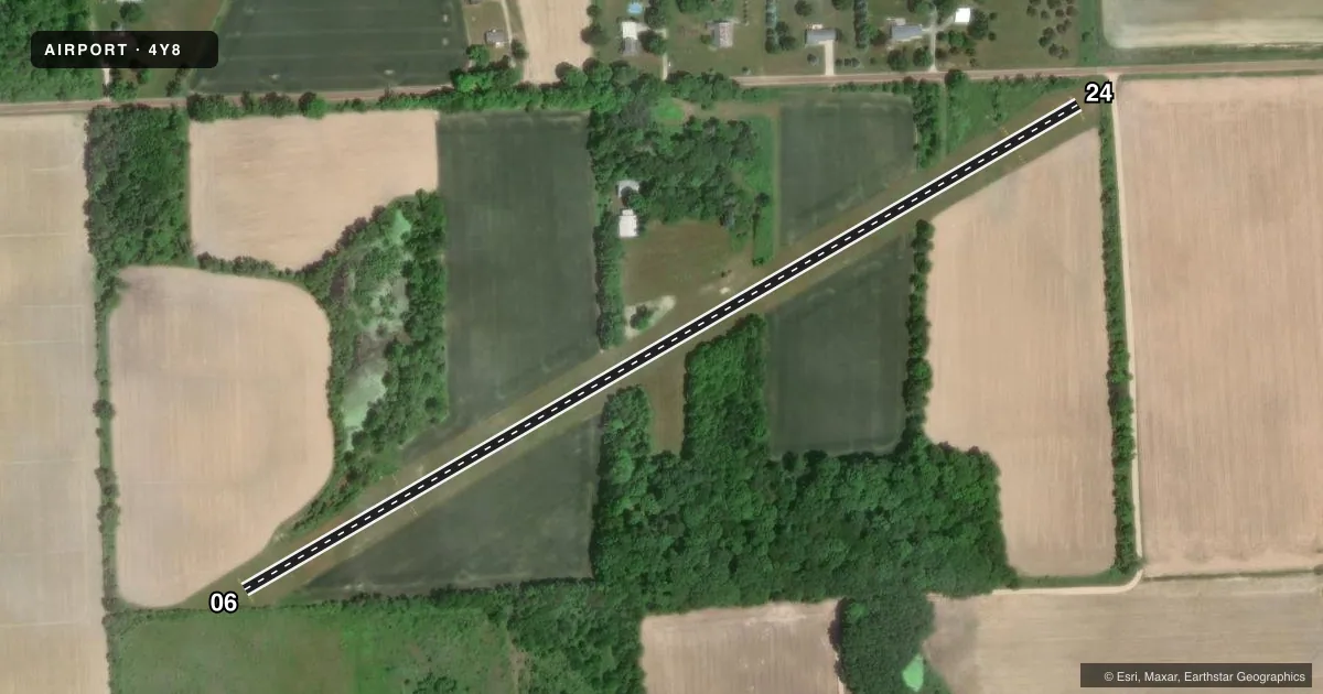
Airport sketch
Runways drawn to scale from FAA survey coordinates, rendered over satellite imagery. Not for navigation.
Approaches & charts
Services on the field
Fuel grades, oxygen, maintenance, ramp storage and lighting — as declared to the FAA by the airport operator.
Fuel & services
- Fuel
- Not available
Ramp & ground
- Transient storage
- Not published
- Landing fee
- No fee published
- Wind indicator
- Yes
- Segmented circle
- No
Fuel & FBOs
Cheapest 100LL and Jet A on the field and nearby. Always confirm with the FBO before taxi.
Airport notes
Surface conditions, obstructions, local procedures, lighting outages and other notes published with each FAA cycle.
General notes
- OPPOSITE RWY END NOT VSB FM THR DUE TO ROLLING TRRN, RWY UPSLP AT BOTH ENDS.
- FOR CD CTC CLEVELAND ARTCC AT 440-774-0224/0490.
- DEER & LRG BIRDS ON & INVOF ARPT.
Runway surface & condition
- 06/24CLSD OCT-MAR & WHEN SNOW COVD.
Approach & departure obstructions
- 06RWY & DTHR MKD WITH CONES.
- 24RWY & DTHR MKD WITH CONES.
- 06CTLG OBSTN EXCEEDS A 45 DEG SLP. APCH RATIO 0:1 TO DTHR OVR +29 FT TREE, 2 FT DIST, 68 FT L.
- 24CTLG OBSTN EXCEEDS A 45 DEG SLP. APCH RATIO 4:1 TO DTHR OVR +45 FT TREE, 185 FT DIST, 60 FT R.
Other notes
- MAN-MADE OR NATURAL OBJECTS EXIST WI THE ASP NEEDED TO ENSURE SAFETY IN THE TKOF/LDG OF ACFT.
- 1ARPT CLSD OCT-MAR & WHEN SNOW COVD - CTC AMGR FOR FICONS.
VFR map & nearby airports
VFR sectional. Tap any ICAO chip to open that airport.
Key facts · 4Y8
Answer card- ICAO
- 4Y8
- Name
- PARA FLD
- Location
- YALE, MICHIGAN
- Elevation
- 800 ft MSL
- Traffic pattern altitude
- 1,800 ft MSL (1,000 AGL)
- Control tower
- Non-towered (use CTAF)
- Total runways
- 1
- Longest runway
- 06/24 · 2,500 ft
- Published ILS approaches
- 0
- Published frequencies
- 1
- Magnetic variation
- 6°
- Current flight rules
- VFR
- Current wind
- 210° at 10 kt
- Favored runway now
- RWY 24
PARA FLD (4Y8) sits near Yale, Michigan. Field elevation is 800 ft MSL. The airport has one runway. Runway 06/24 is 2,500 ft of turf. No control tower is published, so CTAF is the main traffic advisory frequency at 122.9. No ILS approaches are published here.
Pattern altitude is not published. Use the standard 1,000 ft AGL for light piston operations unless the current Chart Supplement says otherwise. That puts the pattern about 1,800 ft MSL based on the field elevation. Verify before you fly. The published remarks matter here. Deer and large birds are reported on and near the airport. The runway is also closed from October through March and when snow covered. The airport is closed in that same seasonal window when conditions warrant. Contact the airport manager for field conditions.
The runway environment needs a careful look. The opposite end is not visible from the threshold because of rolling terrain. The runway also slopes up at both ends. Runway and displaced threshold markings are shown with cones. There are published obstructions near both ends of the runway. This is a field where a first-time pilot should plan a conservative approach, verify current conditions and be ready to go around if the surface or terrain does not look right.