METAR & TAF 2E2
2E2 does not publish a METAR.
Showing the nearest reporting station: KPHN (ST CLAIR COUNTY INTL) · 11.1 NM away. Conditions at 2E2 may differ.
METAR · KPHN
Observed 23:35Z
KPHN 272335Z AUTO 00000KT 10SM CLR 27/18 A2969 RMK AO2
- Wind
- 000° @ 0 kt
- Visibility
- 10 SM
- Temp / Dew
- 27°C / 18°C
- Altimeter
- 29.69 inHg
- Clouds
- CLR
- Density alt
- 2,694 ft
- Ceiling
- Unlimited
- Rules
- VFR
Airport info & contacts
Manager on record, flight service, ARTCC, attendance schedule and pattern altitude — published by the FAA and refreshed every 28 days.
Location
- From city
- 2 NM S
- VFR sectional
- DETROIT
- ARTCC
- ZOB · CLEVELAND
- NOTAM facility
- LAN (NOTAM-D)
Airport manager
- Name
- VICTOR ADAMKO
- Phone
- 810-300-2586
- Address
- 11371 HILL RD, RILEY MI 48041-2005
Flight service · Hours
- FSS LAN
- LANSING1-800-WX-BRIEF
- Attendance
- IREG
Frequencies
Tap any row to copy the frequency to your clipboard.
Runways & pattern
Full pagePattern entry · RWY 18
LEFT TRAFFICRunway end performance
| End | TORA | TODA | ASDA | LDA | VGSI | Approach lights | Obstruction |
|---|---|---|---|---|---|---|---|
| 18 | — | — | — | — | — | — | 26', pline, 74' from thr, 125' R of cntrln, slope 3 |
| 36 | — | — | — | — | — | — | 20', trees, 0' from thr, 68' R of cntrln, slope 1 |
Declared distances in feet. TORA = takeoff run available, TODA = takeoff distance, ASDA = accelerate-stop, LDA = landing distance.
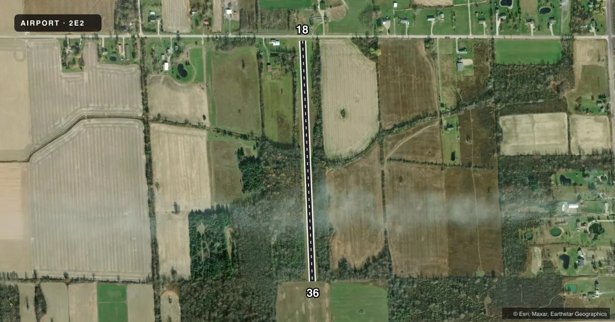
Airport sketch
Runways drawn to scale from FAA survey coordinates, rendered over satellite imagery. Not for navigation.
Approaches & charts
Services on the field
Fuel grades, oxygen, maintenance, ramp storage and lighting — as declared to the FAA by the airport operator.
Fuel & services
- Fuel
- Not available
Ramp & ground
- Transient storage
- Not published
- Wind indicator
- Yes
Fuel & FBOs
Cheapest 100LL and Jet A on the field and nearby. Always confirm with the FBO before taxi.
Airport notes
Surface conditions, obstructions, local procedures, lighting outages and other notes published with each FAA cycle.
General notes
- DEER & TURKEYS INVOF ARPT.
- FOR CD CTC CLEVELAND ARTCC ON FREQ 126.52/285.52 OR CALL 440-774-0224/0490.
- FOR RWY CONDS WHEN SNOW COVD CALL AMGR.
Approach & departure obstructions
- 18RWY & DTHR MKD WITH YELLOW CONES.
- 36YELLOW CONES.
- 18APCH RATIO 1:1 TO DTHR OVR +55 FT TREES, 0 FT DIST, 92 FT R.
Other notes
- PRVDD CLEAR 20:1 APCHS & CLEAR OFZ.
VFR map & nearby airports
VFR sectional. Tap any ICAO chip to open that airport.
Key facts · 2E2
Answer card- ICAO
- 2E2
- Name
- SHARPE'S STRIP
- Location
- EMMETT, MICHIGAN
- Elevation
- 781 ft MSL
- Traffic pattern altitude
- 1,781 ft MSL (1,000 AGL)
- Control tower
- Non-towered (use CTAF)
- Total runways
- 1
- Longest runway
- 18/36 · 2,700 ft
- Published ILS approaches
- 0
- Published frequencies
- 1
- Magnetic variation
- –
- Current flight rules
- VFR
- Current wind
- 000° at 0 kt
- Favored runway now
- –
Sharpe's Strip sits near Emmett, Michigan. Field elevation is 781 ft MSL. The airport has one runway. Runway 18/36 is 2,700 ft of turf, which is the longest runway on the field. There is no control tower. CTAF is 122.9.
No ILS approaches are published here. Pattern altitude is not published, so use 1,000 ft AGL for light piston operations unless the current Chart Supplement says otherwise. The runway and the displaced threshold on 18 are marked with yellow cones. Runway end 36 is also marked with yellow cones. Published remarks also note deer and turkeys in the area. Keep a sharp scan on taxi, takeoff and landing.
For clearance delivery, the published remarks point pilots to Cleveland ARTCC. Snow-covered runway conditions should be checked with the airport manager before you go. There are no on-field FBOs listed in the facts, so verify services directly with the airport operator before arrival. This is a simple turf strip with no published ILS and no tower. Plan for self-announce traffic and current field condition checks before you launch.