METAR & TAF 57D
57D does not publish a METAR.
Showing the nearest reporting station: KVLL (OAKLAND/TROY) · 17.3 NM away. Conditions at 57D may differ.
METAR · KVLL
Observed 16:15Z
KVLL 271615Z AUTO 25014KT 10SM BKN029 BKN035 BKN043 30/22 A2980 RMK AO2
- Wind
- 250° @ 14 kt
- Visibility
- 10 SM
- Temp / Dew
- 30°C / 22°C
- Altimeter
- 29.80 inHg
- Clouds
- BKN
- Density alt
- 2,732 ft
- Ceiling
- 2,900 ft AGL
- Rules
- MVFR
Airport info & contacts
Manager on record, flight service, ARTCC, attendance schedule and pattern altitude — published by the FAA and refreshed every 28 days.
Location
- From city
- 2 NM SE
- VFR sectional
- DETROIT
- ARTCC
- ZOB · CLEVELAND
- NOTAM facility
- LAN (NOTAM-D)
Airport manager
- Name
- JOSEPH KOZAR
- Phone
- 586-999-8665
- Address
- 59819 INDIAN TRL, RAY MI 48096-3809
Flight service · Hours
- FSS LAN
- LANSING1-800-WX-BRIEF
- Attendance
- 1000-1600
Frequencies
Tap any row to copy the frequency to your clipboard.
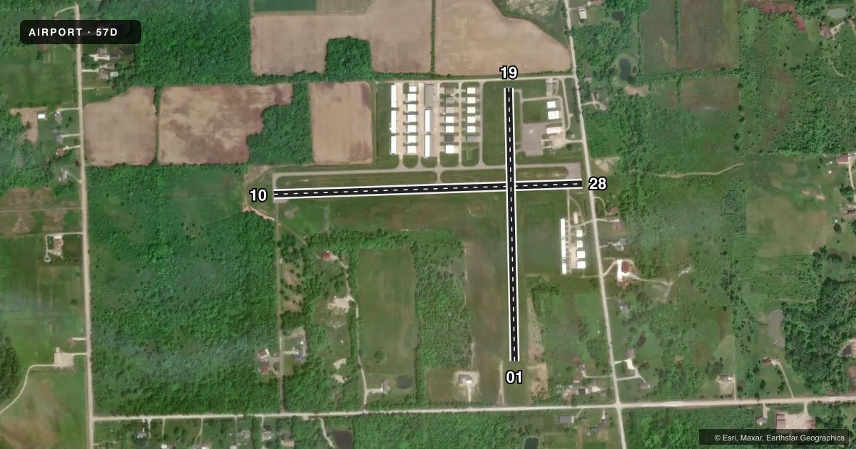
Runways & pattern
Full pagePattern entry · RWY 28
LEFT TRAFFIC| Runway | Heading (°M) | Length | Surface | Traffic |
|---|---|---|---|---|
| 10/28Favored | 82° / 262° | 2,495 ft | ASPH | Standard L |
| 01/19 | 353° / 173° | 2,202 ft | ASPH-TURF | Standard L |
Runway end performance
| End | TORA | TODA | ASDA | LDA | VGSI | Approach lights | Obstruction |
|---|---|---|---|---|---|---|---|
| 10 | — | — | — | — | PAPI 2-box left(3°) | — | — |
| 28 | — | — | — | — | PAPI 2-box left | — | 43', tree, 757' from thr, 100' R of cntrln, slope 12 |
| 01 | — | — | — | — | — | — | 27', tree, 439' from thr, 125' R of cntrln, slope 16 |
Declared distances in feet. TORA = takeoff run available, TODA = takeoff distance, ASDA = accelerate-stop, LDA = landing distance.
Airport sketch
Runways drawn to scale from FAA survey coordinates, rendered over satellite imagery. Not for navigation.
Approaches & charts
Services on the field
Fuel grades, oxygen, maintenance, ramp storage and lighting — as declared to the FAA by the airport operator.
Fuel & services
- Fuel
- 100LL
- Oxygen (bottled)
- Not available
- Oxygen (bulk)
- Not available
- Airframe repair
- Major
- Power plant repair
- Major
Ramp & ground
- Transient storage
- Tie-down
- Landing fee
- No fee published
- Customs
- Not available
- Lighting schedule
- SEE RMK
- Beacon schedule
- SEE RMK
- Beacon
- White / Green (civil land)(WG)
- Wind indicator
- Lighted
- Segmented circle
- Yes
Fuel & FBOs
Cheapest 100LL and Jet A on the field and nearby. Always confirm with the FBO before taxi.
Airport notes
Surface conditions, obstructions, local procedures, lighting outages and other notes published with each FAA cycle.
General notes
- DEER & LRG BIRDS ON & INVOF ARPT.
- ULTRALIGHT OPS.
- FOR CD CTC SELFRIDGE APCH AT 586-239-5706, WHEN APCH CLSD CTC DETROIT APCH AT 734-955-1404.
Lighting notes
- ACTVT ABN - CTAF.
- ACTVT PAPI RWY 10 & 28; MIRL RWY 10/28 - CTAF.
Fuel notes
- 100LLAVBL H24 SELF SVC VIA CREDIT CARD MACHINE IN TRML BLDG.
Approach & departure obstructions
- 28ROAD, 65 FT DIST.
- 013 FT YELLOW CONES.
- 193 FT YELLOW CONES.
- 10+8 FT SEASONAL CROPS, 226 FT DIST.
- 19APCH RATIO 20:1 TO DTHR.
- 28APCH RATIO 20:1 TO DTHR.
Other notes
- ESTABD BFR 1959.
- MANAGERADMIN BLDG 586-749-9558.
VFR map & nearby airports
VFR sectional. Tap any ICAO chip to open that airport.
Key facts · 57D
Answer card- ICAO
- 57D
- Name
- RAY COMMUNITY
- Location
- RAY, MICHIGAN
- Elevation
- 632 ft MSL
- Traffic pattern altitude
- 1,632 ft MSL (1,000 AGL)
- Control tower
- Non-towered (use CTAF)
- Total runways
- 2
- Longest runway
- 10/28 · 2,495 ft
- Published ILS approaches
- 0
- Published frequencies
- 4
- Magnetic variation
- 6°
- Current flight rules
- MVFR
- Current wind
- 250° at 14 kt
- Favored runway now
- RWY 28
Ray Community Airport sits in Ray, Michigan at 632 ft MSL. It has two runways. The longest is 2,495 ft on runway 10/28. There is no control tower. No ILS approaches are published. The pattern altitude is not published, so plan on the standard 1,000 ft AGL for light piston traffic unless the current Chart Supplement says otherwise.
The field has one on-field FBO. Ray Community Airport carries 100LL. Self-serve 100LL is available 24 hours a day by credit card machine in the terminal building. The airport manager can be reached at the administration building if you need local coordination before arrival.
A few operational items matter here. The airport beacon is activated on CTAF. Runways 10 and 28 have PAPI lighting. Runways 10 and 28 also have medium intensity runway lights that are activated on CTAF. Runway 28 has a road close to the departure end. Seasonal crops sit near the departure end of runway 10. Deer and large birds are reported on and near the airport. Ultralight operations also occur here. If you are coming in from the Detroit area, clearance delivery is handled through Selfridge Approach when it is open. Check the current Chart Supplement for any local procedures before you go.