METAR & TAF 39G
39G does not publish a METAR.
Showing the nearest reporting station: KPHN (ST CLAIR COUNTY INTL) · 9.5 NM away. Conditions at 39G may differ.
METAR · KPHN
Observed 20:35Z
KPHN 272035Z AUTO 03009KT 10SM BKN050 28/21 A2975 RMK AO2
- Wind
- 030° @ 9 kt
- Visibility
- 10 SM
- Temp / Dew
- 28°C / 21°C
- Altimeter
- 29.75 inHg
- Clouds
- BKN
- Density alt
- 2,671 ft
- Ceiling
- 5,000 ft AGL
- Rules
- VFR
Airport info & contacts
Manager on record, flight service, ARTCC, attendance schedule and pattern altitude — published by the FAA and refreshed every 28 days.
Location
- From city
- 2 NM SE
- VFR sectional
- DETROIT
- ARTCC
- ZOB · CLEVELAND
- NOTAM facility
- LAN (NOTAM-D)
Airport manager
- Name
- DOUGLAS PULVER
- Phone
- 810-434-4426
- Address
- 8411 IMLAY CITY RD, AVOCA MI 48006-3610
Flight service · Hours
- FSS LAN
- LANSING1-800-WX-BRIEF
- Attendance
- IREG
Frequencies
Tap any row to copy the frequency to your clipboard.
Runways & pattern
Full pagePattern entry · RWY 09
LEFT TRAFFICRunway end performance
| End | TORA | TODA | ASDA | LDA | VGSI | Approach lights | Obstruction |
|---|---|---|---|---|---|---|---|
| 09 | — | — | — | — | — | — | 50', trees, 76' from thr, 125' R of cntrln, slope 1 |
| 27 | — | — | — | — | — | — | 86', trees, 0' from thr, 77' R of cntrln, slope 0 |
Declared distances in feet. TORA = takeoff run available, TODA = takeoff distance, ASDA = accelerate-stop, LDA = landing distance.
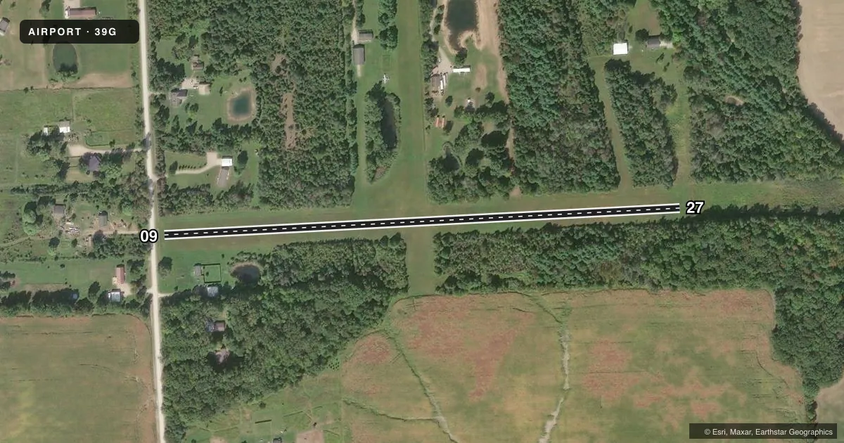
Airport sketch
Runways drawn to scale from FAA survey coordinates, rendered over satellite imagery. Not for navigation.
Approaches & charts
Services on the field
Fuel grades, oxygen, maintenance, ramp storage and lighting — as declared to the FAA by the airport operator.
Fuel & services
- Fuel
- Not available
- Oxygen (bottled)
- Not available
- Oxygen (bulk)
- Not available
- Airframe repair
- Not available
- Power plant repair
- Not available
Ramp & ground
- Transient storage
- Tie-down
- Buoy
- Landing fee
- No fee published
- Wind indicator
- Yes
- Segmented circle
- No
Fuel & FBOs
Cheapest 100LL and Jet A on the field and nearby. Always confirm with the FBO before taxi.
Airport notes
Surface conditions, obstructions, local procedures, lighting outages and other notes published with each FAA cycle.
General notes
- ULTRALIGHT OPS AT ARPT.
- FOR CD CTC SELFRIDGE APCH AT 586-239-5706, WHEN APCH CLSD CTC CLEVELAND ARTCC AT 440-774-0224/0490.
- DEER & LRG BIRDS ON & INVOF ARPT.
Approach & departure obstructions
- 09RWY & DTHR MKD WITH 3 FT YELLOW CONES.
- 27RWY & DTHR MKD WITH 3 FT YELLOW CONES.
- 09APCH RATIO 0:1 TO DTHR OVR +73 FT TREE, 0 FT DIST, 98 FT L.
- 27CTLG OBSTN EXCEEDS A 45 DEG SLP. APCH RATIO 0:1 TO DTHR OVR +45 FT TREE, 0 FT DIST, 64 FT L.
Other notes
- PRVDD AREA 125 FT EITHER SIDE OF RWY CNTRLN & 200 FT OFF EACH END IS CLEAR; PARKED ACFT ARE TO RMN OUTSIDE THIS AREA; ANY OBSTN BE REMOVED/LWRD OR THR DSPLCD TO PRVD A CLEAR 20:1; LOA DATED 11/28/93 RMNS IN EFCT.
- 09/27SOFT IN SPRING & AFT HVY RAIN.
VFR map & nearby airports
VFR sectional. Tap any ICAO chip to open that airport.
Key facts · 39G
Answer card- ICAO
- 39G
- Name
- AVOCA
- Location
- AVOCA, MICHIGAN
- Elevation
- 726 ft MSL
- Traffic pattern altitude
- 1,726 ft MSL (1,000 AGL)
- Control tower
- Non-towered (use CTAF)
- Total runways
- 1
- Longest runway
- 09/27 · 2,105 ft
- Published ILS approaches
- 0
- Published frequencies
- 1
- Magnetic variation
- –
- Current flight rules
- VFR
- Current wind
- 030° at 9 kt
- Favored runway now
- RWY 09
Avoca Airport (39G) sits in Avoca, Michigan at 726 ft MSL. It has one runway, 09/27, with a longest length of 2,105 ft on turf. There is no control tower. CTAF is 122.9. No ILS approaches are published here. The pattern altitude is not published, so use the standard 1,000 ft AGL for light piston operations unless the current Chart Supplement says otherwise.
This is a small turf field, so surface condition matters. The runway is reported soft in spring and after heavy rain. Runway and displaced threshold areas are marked with 3-foot yellow cones on both ends. There are also published obstructions near both ends. Runway 09 has a tree near the approach path. Runway 27 has a tree close to the approach path as well. Deer and large birds are reported on and near the airport. Ultralight operations also occur here.
No on-field FBOs are listed, so verify fuel and services with the airport operator or the FBO directly by phone before you go. For clearance delivery, the published remarks direct pilots to Selfridge Approach. If that is closed, contact Cleveland ARTCC. First-time visitors should plan for a short turf strip, soft-field conditions and a close look at the current runway environment before committing to landing.