METAR & TAF D99
D99 does not publish a METAR.
Showing the nearest reporting station: KPHN (ST CLAIR COUNTY INTL) · 8.8 NM away. Conditions at D99 may differ.
METAR · KPHN
Observed 19:35Z
KPHN 271935Z AUTO 29003KT 10SM CLR 29/21 A2976 RMK AO2
- Wind
- 290° @ 3 kt
- Visibility
- 10 SM
- Temp / Dew
- 29°C / 21°C
- Altimeter
- 29.76 inHg
- Clouds
- CLR
- Density alt
- 2,684 ft
- Ceiling
- Unlimited
- Rules
- VFR
Airport info & contacts
Manager on record, flight service, ARTCC, attendance schedule and pattern altitude — published by the FAA and refreshed every 28 days.
Location
- From city
- 4 NM E
- VFR sectional
- DETROIT
- ARTCC
- ZOB · CLEVELAND
- NOTAM facility
- LAN (NOTAM-D)
Airport manager
- Name
- PAUL ROBERTSON
- Phone
- 810-543-2984
- Address
- 3390 HESSEN RD, CASCO MI 48064-1412
Flight service · Hours
- FSS LAN
- LANSING1-800-WX-BRIEF
- Attendance
- Unattended
Frequencies
Tap any row to copy the frequency to your clipboard.
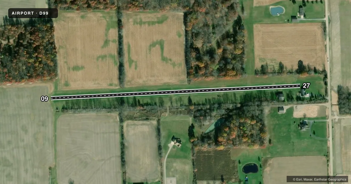
Runways & pattern
Full pagePattern entry · RWY 27
LEFT TRAFFICRunway end performance
| End | TORA | TODA | ASDA | LDA | VGSI | Approach lights | Obstruction |
|---|---|---|---|---|---|---|---|
| 09 | — | — | — | — | — | — | 94', trees, 721' from thr, 0' R of cntrln, slope 7 |
| 27 | — | — | — | — | — | — | 58', tree, 253' from thr, 10' R of cntrln, slope 4 |
Declared distances in feet. TORA = takeoff run available, TODA = takeoff distance, ASDA = accelerate-stop, LDA = landing distance.
Airport sketch
Runways drawn to scale from FAA survey coordinates, rendered over satellite imagery. Not for navigation.
Approaches & charts
Services on the field
Fuel grades, oxygen, maintenance, ramp storage and lighting — as declared to the FAA by the airport operator.
Fuel & services
- Fuel
- Not available
Ramp & ground
- Transient storage
- Not published
- Wind indicator
- Yes
- Segmented circle
- No
Fuel & FBOs
Cheapest 100LL and Jet A on the field and nearby. Always confirm with the FBO before taxi.
Airport notes
Surface conditions, obstructions, local procedures, lighting outages and other notes published with each FAA cycle.
General notes
- DEER & LRG BIRDS ON & INVOF ARPT.
- FOR CD CTC SELFRIDGE APCH AT 586-239-5706, WHEN APCH CLSD CTC CLEVELAND ARTCC AT 440-774-0224/0490.
Approach & departure obstructions
- 09APCH RATIO 20:1 TO DTHR.
- 27APCH RATIO 20:1 TO DTHR.
VFR map & nearby airports
VFR sectional. Tap any ICAO chip to open that airport.
Key facts · D99
Answer card- ICAO
- D99
- Name
- ROBERTSON FLD
- Location
- RICHMOND, MICHIGAN
- Elevation
- 649.8 ft MSL
- Traffic pattern altitude
- 1,649.8 ft MSL (1,000 AGL)
- Control tower
- Non-towered (use CTAF)
- Total runways
- 1
- Longest runway
- 09/27 · 2,455 ft
- Published ILS approaches
- 0
- Published frequencies
- 1
- Magnetic variation
- 6°
- Current flight rules
- VFR
- Current wind
- 290° at 3 kt
- Favored runway now
- RWY 27
Robertson Fld sits in Richmond, Michigan. Field elevation is 649.8 ft MSL. The airport has one runway. Runway 09/27 is 2,455 ft of turf, which is the longest runway on the field. There is no control tower. CTAF is 122.9.
No ILS approaches are published here. The pattern altitude is not published in the facts, so use the standard 1,000 ft AGL unless the current Chart Supplement says otherwise. That puts the traffic pattern at about 1,649.8 ft MSL based on the field elevation. Verify the current published pattern before you fly. The published remarks also call out displaced threshold approach ratios on both runway ends. That means you should pay close attention to obstacle clearance on final.
There are no on-field FBOs listed in the facts. Contact the airport operator directly before arrival, or call the field on CTAF for current fuel and service availability. The published remarks also note deer and large birds on and near the airport. That matters here. Plan for wildlife on taxi, takeoff and landing. If you need clearance delivery, contact Selfridge Approach at 586-239-5706. When approach is closed, contact Cleveland ARTCC at 440-774-0224 or 440-774-0490.