METAR & TAF D98
D98 does not publish a METAR.
Showing the nearest reporting station: KVLL (OAKLAND/TROY) · 17.7 NM away. Conditions at D98 may differ.
METAR · KVLL
Observed 21:35Z
KVLL 272135Z AUTO 23018G28KT 10SM FEW080 SCT110 27/18 A2969 RMK AO2 PK WND 23028/28 PRESFR
- Wind
- 230° @ 18G28 kt
- Visibility
- 10 SM
- Temp / Dew
- 27°C / 18°C
- Altimeter
- 29.69 inHg
- Clouds
- SCT
- Density alt
- 2,641 ft
- Ceiling
- Unlimited
- Rules
- VFR
Airport info & contacts
Manager on record, flight service, ARTCC, attendance schedule and pattern altitude — published by the FAA and refreshed every 28 days.
Location
- From city
- 2 NM E
- VFR sectional
- DETROIT
- ARTCC
- ZOB · CLEVELAND
- NOTAM facility
- LAN (NOTAM-D)
Airport manager
- Name
- DONALD SCHORSCH
- Phone
- 586-336-9116
- Address
- 15340 32 MILE RD, RAY MI 48096-1017
Flight service · Hours
- FSS LAN
- LANSING1-800-WX-BRIEF
- Attendance
- MON-FRI · 0800-1600
Frequencies
Tap any row to copy the frequency to your clipboard.
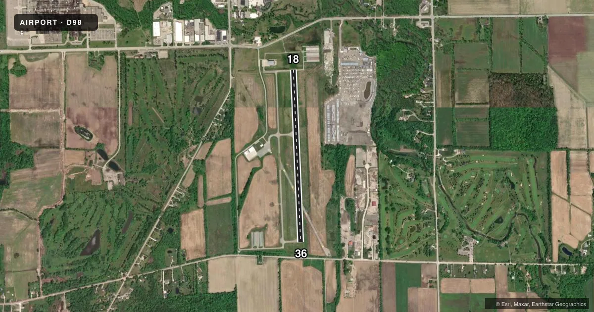
Runways & pattern
Full pagePattern entry · RWY 18
LEFT TRAFFICRunway end performance
| End | TORA | TODA | ASDA | LDA | VGSI | Approach lights | Obstruction |
|---|---|---|---|---|---|---|---|
| 18 | — | — | — | — | PAPI 4-box left(3°) | — | 36', tree, 536' from thr, 223' R of cntrln, slope 9 |
| 36 | — | — | — | — | PAPI 4-box left(3°) | — | 27', tree, 332' from thr, 232' R of cntrln, slope 4 |
Declared distances in feet. TORA = takeoff run available, TODA = takeoff distance, ASDA = accelerate-stop, LDA = landing distance.
Airport sketch
Runways drawn to scale from FAA survey coordinates, rendered over satellite imagery. Not for navigation.
Approaches & charts
Services on the field
Fuel grades, oxygen, maintenance, ramp storage and lighting — as declared to the FAA by the airport operator.
Fuel & services
- Fuel
- 100LLA
- Oxygen (bottled)
- Not available
- Oxygen (bulk)
- Not available
- Airframe repair
- Major
- Power plant repair
- Major
Ramp & ground
- Transient storage
- Tie-down
- Hangar
- Landing fee
- No fee published
- Customs
- Not available
- Lighting schedule
- SEE RMK
- Beacon schedule
- SS-SR
- Beacon
- White / Green (civil land)(WG)
- Wind indicator
- Lighted
- Segmented circle
- No
Fuel & FBOs
Cheapest 100LL and Jet A on the field and nearby. Always confirm with the FBO before taxi.
Airport notes
Surface conditions, obstructions, local procedures, lighting outages and other notes published with each FAA cycle.
General notes
- DEER & LRG BIRDS ON & INVOF ARPT.
- FICONS UNMON DURG UNATNDD HRS EXC WINTER OPS.
- FOR CD CTC SELFRIDGE APCH AT 586-239-5706, WHEN APCH CLSD CTC DETROIT APCH AT 734-955-1404.
- RWY 18 +44 FT PLINE, 750-950 FT NORTH OF THR.
Lighting notes
- ACTVT REIL RWY 18 & 36; PAPI RWY 18 & 36; MIRL RWY 18/36 - CTAF.
Approach & departure obstructions
- 18APCH RATIO 20:1 TO DTHR.
Other notes
- MANAGERCELL 248-730-0561.
VFR map & nearby airports
VFR sectional. Tap any ICAO chip to open that airport.
Key facts · D98
Answer card- ICAO
- D98
- Name
- ROMEO STATE
- Location
- ROMEO, MICHIGAN
- Elevation
- 738.2 ft MSL
- Traffic pattern altitude
- 1,738.2 ft MSL (1,000 AGL)
- Control tower
- Non-towered (use CTAF)
- Total runways
- 1
- Longest runway
- 18/36 · 4,003 ft
- Published ILS approaches
- 0
- Published frequencies
- 4
- Magnetic variation
- 6°
- Current flight rules
- VFR
- Current wind
- 230° at 18 kt
- Favored runway now
- RWY 18
Romeo State Airport sits in Romeo, Michigan. Field elevation is 738.2 ft MSL. The airport has one runway. Runway 18/36 is 4,003 ft long and asphalt. This is an untowered field, so plan to self-announce on CTAF 122.8. The published pattern altitude is not listed. Use the standard 1,000 ft AGL for light piston operations unless the current Chart Supplement says otherwise.
No ILS approaches are published here. The field does have runway end identifier lights, precision approach path indicators and medium intensity runway lights on 18/36. That helps for night work. The remarks also call out deer and large birds in the area. Runway 18 has a 44-foot power line 750 to 950 feet north of the threshold. Give that end a careful look on arrival.
Romeo Airport Management is on the field. It carries 100LL and Jet A. If you need clearance delivery, the published contact is Selfridge Approach when it is open. When that facility is closed, use Detroit Approach. For a first-time arrival, keep the local traffic picture simple. Use 122.8. Make clear position reports. Verify current procedures in the FAA Chart Supplement before you go.