METAR & TAF KVLL
Current METAR
Observed 19:15Z
KVLL 271915Z AUTO 28006G14KT 250V310 10SM CLR 30/19 A2978 RMK AO2 PRESRR
- Wind
- 280° @ 6G14 kt
- Visibility
- 10 SM
- Temp / Dew
- 30°C / 19°C
- Altimeter
- 29.78 inHg
- Clouds
- CLR
- Density alt
- 2,875 ft
- Ceiling
- Unlimited
- Rules
- VFR
Airport info & contacts
Manager on record, flight service, ARTCC, attendance schedule and pattern altitude — published by the FAA and refreshed every 28 days.
Location
- From city
- 2 NM E
- VFR sectional
- DETROIT
- Pattern altitude
- 1,000 ft AGL · 1,727 ft MSL
- ARTCC
- ZOB · CLEVELAND
- NOTAM facility
- VLL (NOTAM-D)
Airport manager
- Name
- CHERYL BUSH
- Phone
- 248-666-3900
- Address
- 6500 PATTERSON PKWY, WATERFORD MI 48327-1683
Flight service · Hours
- FSS LAN
- LANSING1-800-WX-BRIEF
- Attendance
- 0800-1800
Frequencies
Tap any row to copy the frequency to your clipboard.
Runways & pattern
Full pagePattern entry · RWY 28
LEFT TRAFFICRunway end performance
| End | TORA | TODA | ASDA | LDA | VGSI | Approach lights | Obstruction |
|---|---|---|---|---|---|---|---|
| 10 | — | — | — | — | PAPI 2-box right(3.75°) | — | 23', tree, 200' from thr, 160' R of cntrln, slope 0 |
| 28 | — | — | — | — | PAPI 2-box left(3.75°) | — | 18', tree, 200' from thr, 175' R of cntrln, slope 0 |
Declared distances in feet. TORA = takeoff run available, TODA = takeoff distance, ASDA = accelerate-stop, LDA = landing distance.
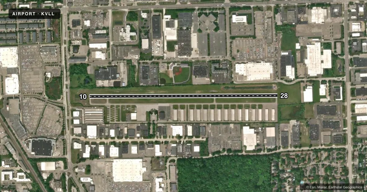
Airport sketch
Runways drawn to scale from FAA survey coordinates, rendered over satellite imagery. Not for navigation.
Approaches & charts
Services on the field
Fuel grades, oxygen, maintenance, ramp storage and lighting — as declared to the FAA by the airport operator.
Fuel & services
- Fuel
- 100LLA+
- Airframe repair
- Not available
- Power plant repair
- Not available
- Other services
- INSTR,RNTL
Ramp & ground
- Transient storage
- Tie-down
- Hangar
- Landing fee
- Yes
- Customs
- Not available
- Lighting schedule
- SEE RMK
- Beacon schedule
- SS-SR
- Beacon
- White / Green (civil land)(WG)
- Wind indicator
- Lighted
- Segmented circle
- No
Fuel & FBOs
Cheapest 100LL and Jet A on the field and nearby. Always confirm with the FBO before taxi.
Airport notes
Surface conditions, obstructions, local procedures, lighting outages and other notes published with each FAA cycle.
General notes
- DEER & LRG BIRDS ON & INVOF ARPT.
- NO TGL OR PRACTICE TFC PATTERNS.
- FOR CD CTC DETROIT APCH AT 734-955-1404.
Lighting notes
- ACTVT PAPI RWY 10 & 28; MIRL RWY 10/28 - CTAF.
Approach & departure obstructions
- 10CTLG OBSTN EXCEEDS A 45 DEG SLP.
- 28CTLG OBSTN EXCEEDS A 45 DEG SLP.
Other notes
- FOR TSNT HNGR STORAGE CTC AMGR.
- MANAGERARPT PHYS ADS: 2672 INDUSTRIAL ROW DR, TROY, MI 48084.
VFR map & nearby airports
VFR sectional. Tap any ICAO chip to open that airport.
Key facts · KVLL
Answer card- ICAO
- KVLL
- Name
- OAKLAND/TROY
- Location
- TROY, MICHIGAN
- Elevation
- 727.2 ft MSL
- Traffic pattern altitude
- 1,727.2 ft MSL (1,000 AGL)
- Control tower
- Non-towered (use CTAF)
- Total runways
- 1
- Longest runway
- 10/28 · 3,549 ft
- Published ILS approaches
- 0
- Published frequencies
- 4
- Magnetic variation
- 6°
- Current flight rules
- VFR
- Current wind
- 280° at 6 kt
- Favored runway now
- RWY 28
Oakland/Troy (KVLL) is in Troy, Michigan. The field elevation is 727.2 ft MSL. It has one runway, 10/28, which is 3,549 ft long. There is no control tower. Traffic uses CTAF 123.05. The pattern altitude is 1,000 ft AGL, which is 1,727.2 ft MSL.
No ILS approaches are published here. The runway lighting setup includes medium intensity runway lights on 10/28. The precision approach path indicators are also active on both ends. Published remarks note obstacles near both runway ends. The chart supplement says cataloged obstacles exceed a 45 degree slope at runway 10. It says the same for runway 28. Deer and large birds are also reported on and near the airport.
24HRFUEL is on the field. It carries AVGAS 100LL and Jet A Prist. For clearance delivery, Detroit Approach can be reached at 734-955-1404. No touch-and-go or practice traffic patterns are permitted, so plan a full stop or other approved operation. If you need transient hangar storage, contact the airport manager. The airport physical address is 2672 Industrial Row Drive, Troy, Michigan 48084.