METAR & TAF Y47
Y47 does not publish a METAR.
Showing the nearest reporting station: KPTK (OAKLAND COUNTY INTL) · 13.3 NM away. Conditions at Y47 may differ.
METAR · KPTK
Observed 16:53Z
KPTK 271653Z 26012KT 10SM FEW034 FEW045 OVC180 29/19 A2979 RMK SLPNO T02910193
- Wind
- 260° @ 12 kt
- Visibility
- 10 SM
- Temp / Dew
- 29°C / 19°C
- Altimeter
- 29.79 inHg
- Clouds
- OVC
- Density alt
- 2,990 ft
- Ceiling
- 18,000 ft AGL
- Rules
- VFR
Airport info & contacts
Manager on record, flight service, ARTCC, attendance schedule and pattern altitude — published by the FAA and refreshed every 28 days.
Location
- From city
- 1 NM SW
- VFR sectional
- DETROIT
- ARTCC
- ZOB · CLEVELAND
- NOTAM facility
- LAN (NOTAM-D)
Airport manager
- Name
- CHERYL BUSH
- Phone
- 248-666-3900
- Address
- 6500 PATTERSON PKWY, WATERFORD MI 48327-1683
Flight service · Hours
- FSS LAN
- LANSING1-800-WX-BRIEF
- Attendance
- MON-FRI · 0830-1700
- SAT-SUN · ON CALL
Frequencies
Tap any row to copy the frequency to your clipboard.
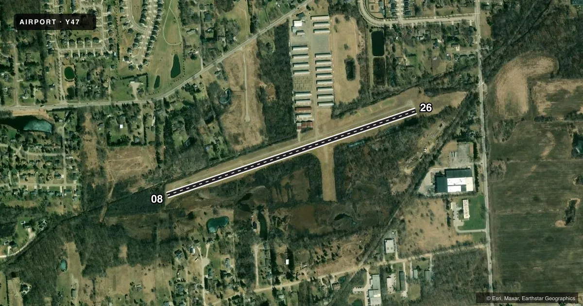
Runways & pattern
Full pagePattern entry · RWY 26
LEFT TRAFFICRunway end performance
| End | TORA | TODA | ASDA | LDA | VGSI | Approach lights | Obstruction |
|---|---|---|---|---|---|---|---|
| 08 | — | — | — | — | VASI 2-box right(4°) | — | 20', brush, 200' from thr, 98' R of cntrln, slope 0 |
| 26 | — | — | — | — | VASI 2-box left(4°) | — | 79', trees, 200' from thr, 125' R of cntrln, slope 0 |
Declared distances in feet. TORA = takeoff run available, TODA = takeoff distance, ASDA = accelerate-stop, LDA = landing distance.
Airport sketch
Runways drawn to scale from FAA survey coordinates, rendered over satellite imagery. Not for navigation.
Approaches & charts
Services on the field
Fuel grades, oxygen, maintenance, ramp storage and lighting — as declared to the FAA by the airport operator.
Fuel & services
- Fuel
- 100LL
- Oxygen (bottled)
- Not available
- Oxygen (bulk)
- Not available
Ramp & ground
- Transient storage
- Tie-down
- Hangar
- Landing fee
- No fee published
- Customs
- Not available
- Lighting schedule
- SEE RMK
- Beacon schedule
- SS-SR
- Beacon
- White / Green (civil land)(WG)
- Wind indicator
- Lighted
- Segmented circle
- Yes
Fuel & FBOs
Cheapest 100LL and Jet A on the field and nearby. Always confirm with the FBO before taxi.
Airport notes
Surface conditions, obstructions, local procedures, lighting outages and other notes published with each FAA cycle.
General notes
- TREES & BRUSH IN PRIMARY SFC 70-120 FT L & R.
- FOR CD CTC DETROIT APCH AT 734-955-1404.
- DEER & LRG BIRDS ON & INVOF ARPT.
Lighting notes
- ACTVT LIRL RWY 08/26 - CTAF. VASI RWY 08 & 26 OTS INDEFLY.
Approach & departure obstructions
- 08-4 FT DITCH, 40 FT DIST; SCATTERED 5-30 FT TREES & BRUSH, 0-199 FT DIST, 125 FT L & R.
- 2615-40 FT TREES & BRUSH, 0-90 FT DIST, 110 FT L.
- 08CTLG OBSTN EXCEEDS A 45 DEG SLP. APCH RATIO 2:1 TO DTHR OVR +22 FT TREE, 62 FT DIST, 125 FT R.
- 26CTLG OBSTN EXCEEDS A 45 DEG SLP. APCH RATIO 0:1 TO DTHR OVR +12 FT TREE, 0 FT DIST, 115 FT L. +30 FT PLINE, 697 FT DIST; +20 FT TREES, 110 FT L; +15-50 FT TREES, MOST QUADS.
Other notes
- ESTABD BFR 1959.
- HNGR AVBL BY PRIOR ARNGMT CTC AMGR.
VFR map & nearby airports
VFR sectional. Tap any ICAO chip to open that airport.
Key facts · Y47
Answer card- ICAO
- Y47
- Name
- OAKLAND SOUTHWEST
- Location
- NEW HUDSON, MICHIGAN
- Elevation
- 926.1 ft MSL
- Traffic pattern altitude
- 1,926.1 ft MSL (1,000 AGL)
- Control tower
- Non-towered (use CTAF)
- Total runways
- 1
- Longest runway
- 08/26 · 3,128 ft
- Published ILS approaches
- 0
- Published frequencies
- 4
- Magnetic variation
- 7°
- Current flight rules
- VFR
- Current wind
- 260° at 12 kt
- Favored runway now
- RWY 26
Oakland Southwest Airport is in New Hudson, Michigan. The field elevation is 926.1 ft MSL. It has one runway. Runway 08/26 is 3,128 ft of asphalt, which is the longest runway on the field. There is no control tower. CTAF and UNICOM are both 122.7. Detroit Approach handles clearance delivery. The published frequencies are 132.35 and 284.0.
No ILS approaches are published here. The pattern altitude is not published, so use the standard 1,000 ft AGL for light piston operations unless the current Chart Supplement says otherwise. Oakland Southwest Airport is an on-field FBO. It carries 100LL. Call (248) 437-2333 for current services.
This is a field where the published remarks matter. Runway lights on 08/26 are activated by CTAF at low intensity. The VASI on both ends is out of service indefinitely. The remarks also call out trees, brush, a ditch near runway 08 and several obstructions near both ends. Runway 26 has a tree right at the displaced threshold area. Power lines and more trees are left of centerline. Deer and large birds are also reported on and near the airport. If you are planning a first visit, brief the departure and arrival carefully. Check the current Chart Supplement for any updated operational notes.