METAR & TAF KOZW
Current METAR
Observed 16:35Z
KOZW 271635Z AUTO 27012G16KT 10SM CLR 29/19 A2980 RMK AO2
- Wind
- 270° @ 12G16 kt
- Visibility
- 10 SM
- Temp / Dew
- 29°C / 19°C
- Altimeter
- 29.80 inHg
- Clouds
- CLR
- Density alt
- 3,022 ft
- Ceiling
- Unlimited
- Rules
- VFR
Airport info & contacts
Manager on record, flight service, ARTCC, attendance schedule and pattern altitude — published by the FAA and refreshed every 28 days.
Location
- From city
- 3 NM NW
- VFR sectional
- DETROIT
- Pattern altitude
- 1,039 ft AGL · 2,001 ft MSL
- ARTCC
- ZOB · CLEVELAND
- NOTAM facility
- OZW (NOTAM-D)
Airport manager
- Name
- MARK D JOHNSON
- Phone
- 517-546-6675
- Address
- 3399 COUNTY AIRPORT DR, HOWELL MI 48855
Flight service · Hours
- FSS LAN
- LANSING1-800-WX-BRIEF
- Attendance
- MON-FRI · 0700-1700
- SAT-SUN · 0800-1200
Frequencies
Tap any row to copy the frequency to your clipboard.
Runways & pattern
Full pagePattern entry · RWY 31
LEFT TRAFFICRunway end performance
| End | TORA | TODA | ASDA | LDA | VGSI | Approach lights | Obstruction |
|---|---|---|---|---|---|---|---|
| 13 | — | — | — | — | PAPI 4-box left(3°) | MALSR | 58', tree, 1313' from thr, 650' R of cntrln, slope 19 |
| 31 | — | — | — | — | PAPI 4-box left(3°) | — | 40', tree, 471' from thr, 550' R of cntrln, slope 6 |
Declared distances in feet. TORA = takeoff run available, TODA = takeoff distance, ASDA = accelerate-stop, LDA = landing distance.
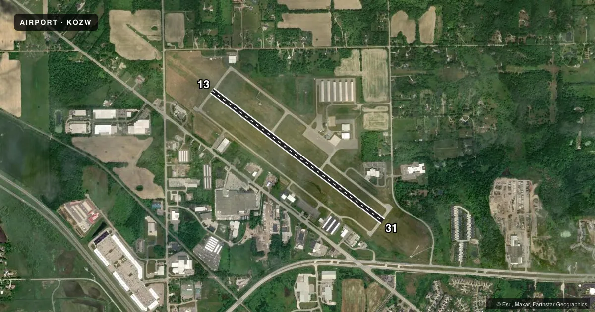
Airport sketch
Runways drawn to scale from FAA survey coordinates, rendered over satellite imagery. Not for navigation.
Approaches & charts
ILS · 1
Services on the field
Fuel grades, oxygen, maintenance, ramp storage and lighting — as declared to the FAA by the airport operator.
Fuel & services
- Fuel
- 100LLAA+
- Airframe repair
- Major
- Power plant repair
- Major
- Other services
- AMB,CHTR,INSTR,RNTL
Ramp & ground
- Transient storage
- Tie-down
- Hangar
- Landing fee
- No fee published
- Customs
- Not available
- Lighting schedule
- SEE RMK
- Beacon schedule
- SS-SR
- Beacon
- White / Green (civil land)(WG)
- Wind indicator
- Lighted
- Segmented circle
- Yes
Fuel & FBOs
Cheapest 100LL and Jet A on the field and nearby. Always confirm with the FBO before taxi.
Airport notes
Surface conditions, obstructions, local procedures, lighting outages and other notes published with each FAA cycle.
General notes
- DEER & LRG BIRDS ON & INVOF ARPT.
- GCO AVBL ON FREQ 121.725 THRU DTW CLNC DEL & FLT SVCS.
- FOR CD CTC DETROIT APCH AT 734-955-1404.
Lighting notes
- ACTVT OR INCR INTST MALSR RWY 13; REIL RWY 31; HIRL RWY 13/31 - CTAF. PAPI RWY 13 & 31 OPR CONSLY DAWN-DUSK; HIRL RWY 13/31 PRESET LOW INTST DUSK-2200.
VFR map & nearby airports
VFR sectional. Tap any ICAO chip to open that airport.
Key facts · KOZW
Answer card- ICAO
- KOZW
- Name
- LIVINGSTON COUNTY/SPENCER J HARDY
- Location
- HOWELL, MICHIGAN
- Elevation
- 962 ft MSL
- Traffic pattern altitude
- 2,001 ft MSL (1,039 AGL)
- Control tower
- Non-towered (use CTAF)
- Total runways
- 1
- Longest runway
- 13/31 · 5,002 ft
- Published ILS approaches
- 1
- Published frequencies
- 5
- Magnetic variation
- 5°
- Current flight rules
- VFR
- Current wind
- 270° at 12 kt
- Favored runway now
- RWY 31
Livingston County/Spencer J Hardy Airport sits in Howell, Michigan. The field elevation is 962 ft MSL. It has one runway. Runway 13/31 is 5,002 ft long with concrete pavement. The airport is not towered. Pattern altitude is 1,039 ft AGL, which is 2,001 ft MSL. The published ILS is for runway 13.
The on-field FBO is Livingston County Airport. It carries 100LL, Jet A and Jet A Prist. Call them at (517) 546-6675 for current service details. Published remarks also note ground communications on 121.725 through Detroit clearance delivery and flight services. For clearance delivery, contact Detroit Approach at 734-955-1404.
A first-time pilot should plan for a non-towered environment with CTAF and UNICOM on 123.0. The airport also has deer and large birds on and near the field, so keep a sharp scan on taxi, takeoff and landing. Runway lighting is more than basic. The approach lighting system, runway alignment indicator lights for runway 13, runway end identifier lights for runway 31 and high intensity runway lights are all published. The high intensity lights are preset to low intensity from dusk to 2200. Check the current FAA Chart Supplement for any updated operational notes before flying in.